Backcountry Forum
Backpacking & Hiking Gear

Backcountry Forum
Our long-time Sponsor - the leading source for ultralite/lightweight outdoor gear


Amazon.com
Backpacking Forums
---- Our Gear Store ----
The Lightweight Gear Store
 
 WINTER CAMPING 

Shelters
Bivy Bags
Sleeping Bags
Sleeping Pads
Snow Sports
Winter Kitchen

 SNOWSPORTS 

Snowshoes
Avalanche Gear
Skins
Hats, Gloves, & Gaiters
Accessories

 ULTRA-LIGHT 

Ultralight Backpacks
Ultralight Bivy Sacks
Ultralight Shelters
Ultralight Tarps
Ultralight Tents
Ultralight Raingear
Ultralight Stoves & Cookware
Ultralight Down Sleeping Bags
Ultralight Synthetic Sleep Bags
Ultralight Apparel


the Titanium Page
WM Extremelite Sleeping Bags

 CAMPING & HIKING 

Backpacks
Tents
Sleeping Bags
Hydration
Kitchen
Accessories

 CLIMBING 

Ropes & Cordage
Protection & Hardware
Carabiners & Quickdraws
Climbing Packs & Bags
Big Wall
Rescue & Industrial

 MEN'S APPAREL 

Jackets
Shirts
Baselayer
Headwear
Gloves
Accessories

 WOMEN'S APPAREL 

Jackets
Shirts
Baselayer
Headwear
Gloves
Accessories

 FOOTWEAR 

Men's Footwear
Women's Footwear

 CLEARANCE 

Backpacks
Mens Apparel
Womens Apparel
Climbing
Footwear
Accessories

 BRANDS 

Black Diamond
Granite Gear
La Sportiva
Osprey
Smartwool

 WAYS TO SHOP 

Sale
Clearance
Top Brands
All Brands

 Backpacking Equipment 

Shelters
BackPacks
Sleeping Bags
Water Treatment
Kitchen
Hydration
Climbing


 Backcountry Gear Clearance

Topic Options
Rate This Topic
#165358 - 04/26/12 01:22 PM TR- Panorama Trail, Yosemite
wandering_daisy Offline
member

Registered: 01/11/06
Posts: 2865
Loc: California
Hard way to Climb Sentinel Dome

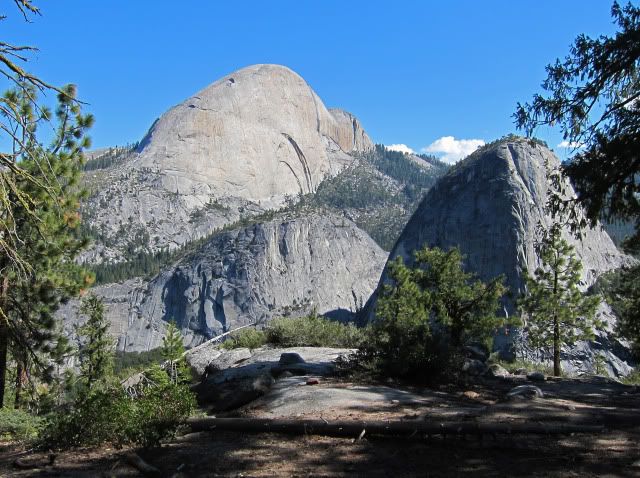
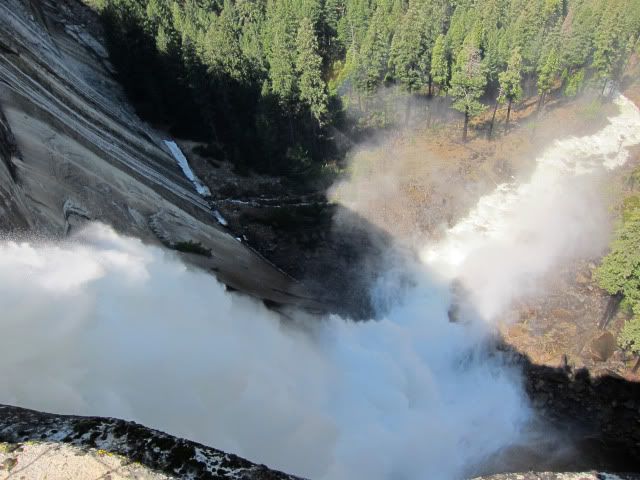
This trip started out with numerous logistical problems. First, I had hoped that Glacier Point Road would be closed; camping logistics get difficult once the road opens. Second I got bad information when I got a permit. I was assured by the ranger that JMT was open and it was legal to park my car at ElCap Meadows. After eating dinner at Camp 4 I pulled out the brochures I was given upon entering, and the maps definitely indicated that overnight parking at ElCap Meadow was not legal. After specifically choosing the more crowded Camp 4 because of the ease of getting to ElCap bridge, I now realized that the plan would not work. I went into the tent and worried. Just as I was about to sleep two guys showed up and set up right next to me and sat there until midnight with bright headlamps and a stinky campfire not 10 feet from my tent. Next morning I awoke at 5:45 AM and slammed the bear boxes loudly as possible as I packed up and left. I felt terrible, almost sick. I decided to reverse the route, parked at Curry Village and got some coffee. By the time I fiddle-farted around and just missed the bus, I finally got started up the trail from Happy Isles at 8:15. As I walked up the trail, I felt better each step. Coffee and walking do miracles! I headed up the JMT and came to the next junction to find the gate closed! Damned if I was going to drop down and go up the Mist Trail. I scooted by the gate and continued. At the crux, there was a thin trench between the ice and rock wall that I easily got through. I met a couple going down. Finally I reached the Panorama Trail junction a bit after 10AM. The Panorama Trail was snow free and easy going so I reached Illouette Creek at 11:30. It was now hot and the slog up 1,300 feet to Glacier Point was tedious but with great views. Lots of snow-melt creeks were running so I could soak my bandana and hat in cold water. Several day-hikers were heading down. I took one short rest stop and continued across the road. Immediately, the snow became solid and deep. Footprints went off in many directions. I worked my way to the top, meeting a couple coming down. Thankfully they had broken trail! The view was fantastic and I had left my camera in my pack. Back to my pack, I continued to the Taft Point trailhead. Looking down towards the rim the snow was discouragingly covering nearly everything. Logistics failed me again. I think had it been early AM the snow would not have been so bad.

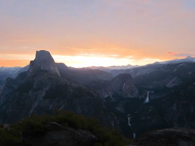
For a goal oriented person, I can at least say I made it to the top of Sentinel Dome . Yes, Glacier Point Road was open making actually climbing Sentinel Dome trivial. But my intent was to do the entire Panorama-Pohono –Yosemite Valley loop – this was just the consolation prize. At 4PM in the afternoon, sitting at the Taft Point parking lot, I realized that getting to Bridalveil Creek was not going to happen. Choices; hitch a ride back to the Valley, slog on to Taft Point and illegally camp there (I have camped there before when the Glacier Point Road was closed), or walk back down the Glacier Point Road and then on the snow-free trail back to legal camping on upper Illouette Creek. I did try to hitch but all I got was “we are too full”, even when the vehicles were obviously not. The thought of getting disoriented and stuck in snow late in the day nixed the second choice. So it was walk back down the shoulder of the road. The two miles went quickly and soon I was heading back down the same trail I came up hours before. My knees were screaming. Going another 3.5 miles was not going to happen. I filled two platypus containers with water and headed to a hidden spot quarter mile off the trail and well hidden for a bit if stealth camping. This was the first time in nine hours that I sat down for more than a few minutes. The evening was sublime. Hot tea, soup, dark chocolate and an amazing sunset- I could not have asked for more, barring the sore knees.

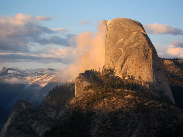
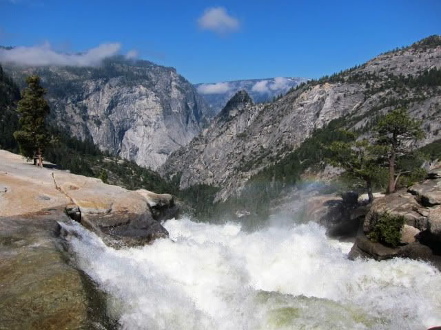
It had been a 9 hour, 13.5 mile, +5450-feet gain day! After a good night’s sleep I was up at 6AM getting some sunrise shots. I packed up and returned to the trail and this time, I took the Mist Trail back to Happy Isles. Surprisingly it took me longer to go downhill than I had gone uphill! I reached my car at 2:30, walking back to Curry Village rather than waiting for the bus. The second day was only 9 miles with 1,500 gain and 4,050 descent. Old knees slowed me down. When I left it was overcast. I guess I really was quite pleased (for myself at least) that when I looked at the Sentinel Web Cam this morning it was raining. Maybe the defeat was really a good call. A few photos below.


Top
#165361 - 04/26/12 04:01 PM Re: TR- Panorama Trail, Yosemite [Re: wandering_daisy]
Heather-ak Offline
member

Registered: 07/11/10
Posts: 597
Loc: Fairbanks, AK
Looks beautiful! How is your long trip planning going?

Top
#165364 - 04/26/12 07:48 PM Re: TR- Panorama Trail, Yosemite [Re: Heather-ak]
wandering_daisy Offline
member

Registered: 01/11/06
Posts: 2865
Loc: California
As for the long trip, I am watching the snowmelt reports, not committing to any plan until later. The Wind Rivers actually can get a lot of snow in May. Right now they are a bit below average. Early melt and I will go north-to-south; average or late melt and I will go south-to-north. Right now I am at one outfitter resupply and one (or two) walk out resupplies. When I start depends on mosquitoes and high water. Snow is not a huge factor in itself, but when it melts, it becomes a factor because I have two critical creek crossings that could stop me cold! Mosquito season is intense, but fairly short and I have no intention of starting out until the worst is over. And of course, mosquito season depends on snow melt.

Has your snow up there melted yet? I see you got LOTS this year.

Top
#165390 - 04/27/12 12:33 PM Re: TR- Panorama Trail, Yosemite [Re: wandering_daisy]
skcreidc Offline
member

Registered: 08/16/10
Posts: 1590
Loc: San Diego CA
I love all the water!! Great time to go visit Yosemite; (I'm guessing) no bugs and no crowds. Thanks for posting...helps to motivate me to get out before June this year.

And good luck on the Winds trip.

Top
#165396 - 04/27/12 03:39 PM Re: TR- Panorama Trail, Yosemite [Re: wandering_daisy]
Heather-ak Offline
member

Registered: 07/11/10
Posts: 597
Loc: Fairbanks, AK
The interior of Alaska got about the normal snow pack this year. The early spring season, which is aptly named "break-up", was fairly painless. We had a dry April with two weeks of temperatures on the high end of normal, so this years break-up was pretty painless. Only snow left is at higher elevations. I've been watching the snow line on the mountains to the south slowly move up grin

Keep us updated on your trip! I'm very jealous and I'm excited for updates too.

Top

Shout Box

Highest Quality Lightweight Down Sleeping Bags
 
Western Mountaineering Sleeping Bags
 
Lite Gear Talk - Featured Topics
Backcountry Discussion - Featured Topics
Yosemite Winter Rangers
by balzaccom
12/21/23 09:35 AM
Make Your Own Gear - Featured Topics
Featured Photos
Spiderco Chaparral Pocketknife
David & Goliath
Also Testing
Trip Report with Photos
Seven Devils, Idaho
Oat Hill Mine Trail 2012
Dark Canyon - Utah
Who's Online
0 registered (), 371 Guests and 0 Spiders online.
Key: Admin, Global Mod, Mod
Newest Members
StarryOwl, Noodles, McCrary, DanyBacky, Rashy Willia
13241 Registered Users
Forum Links
Disclaimer
Policies
Site Links
Backpacking.net
Lightweight Gear Store
Backpacking Book Store
Lightweight Zone
Hiking Essentials

Our long-time Sponsor, BackcountryGear.com - The leading source for ultralite/lightweight outdoor gear:

Backcountry Forum
 

Affiliate Disclaimer: This forum is an affiliate of BackcountryGear.com, Amazon.com, R.E.I. and others. The product links herein are linked to their sites. If you follow these links to make a purchase, we may get a small commission. This is our only source of support for these forums. Thanks.!


Since 1996 - the Original Backcountry Forum
Copyright © The Lightweight Backpacker & BackcountryForum