This has been a long time coming, but it has taken me this long to figure out how to put this together. So, this is the log of a 30 mile backpack loop in the John Muir Wilderness, where the southwest corner is more or less marked by the Muir Trail Ranch. With the five miles to get in and out to the ranch, this makes it 40+ miles total. So lets get to it. Sorry, but I have to come back and fix photos still. Here is what I have so far.
Day 1, August 28, 2010
For my two human companions, this day began at 3:22 am. I know I was still asleep. Although very organized, Mike and Tess have never been on a trip like this before. My wife, Patty, was not thrilled with me doing this alone (even with my SPOT) and had suggested Mike and Tess as possible partners (translation suckers) to do the trip with me. Mike and Tess are avid workout people, doing triathlons as well as other things like running up hills with the largest rock they can carry. Most important, they are good people and I get along with them. We discussed the trip in detail and they wanted to do it. Those two get on it immediately; doing numerous 10 mile + day hikes carrying weight, going up to 10,000 ft twice, and going on one weekend backpack to shake out their gear. I was quite impressed; I told them what to do to prepare and they did it. By 5:00 am, we are loaded up and rolling North towards Fresno.
After a quick stop to pick up our wilderness permits around 11 am, we are off again to Shaver Lake and then on to Florence Lake (el 7330 ft). We finally arrive at Florence a little after 2 pm. Tess goes over to get ferry tickets for all four of us while Mike and I prep the packs and give Tica a little time to wander. The ferry gets us to the other side after 3 pm ; we have about 5.5 miles to get to where we want to camp near Muir Trail Ranch.

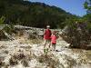
Mike and I checking out the packs while we wait for the ferry.
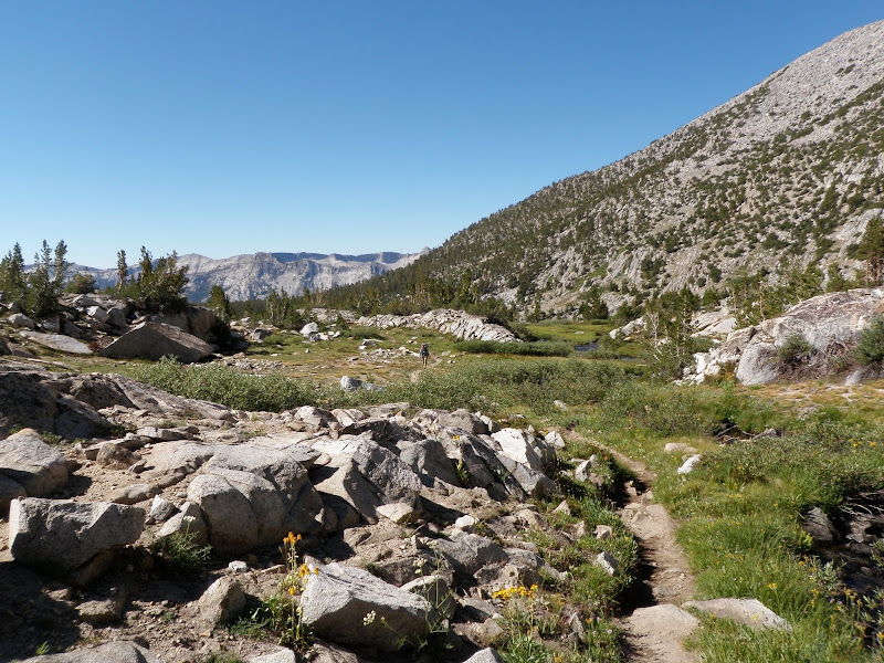
It is a bit cold and nice hiking weather once we get moving; there is obviously some front moving thru the area. The trail is empty for us, and although I have been here many times before, I enjoy every moment of the hike in.

Heading in and wondering what the white ribbons are for.

When we get there, we don't bother with the hot springs across the river. Rather we focus on trying to get the Steri-pen to work. Since Mike and Tess were hot to bring it, I didn't bother to bring my filter. And the thing worked fine at home but now ... we are boiling water. Other highlights include; Mike got to start his first "backpacking" fire, Mike learned that you don't put your food on the ground and leave when there is a dog around, and we learned that they apparently rent out the Muir Trail Ranch for wedding receptions, hence the white ribbons on the way in. That was the loudest night I have ever spent in the "back country".
Day 2, August 29
We woke up (at el 7750 ft) to frozen water bottles and light snow flurries. The snow flurries quickly pass and we immediately jump into a series of switchbacks that takes us up to 10,000 ft.

Panorama view looking south from the switchbacks. Florence Lake is to the right.

Another shot from the switchbacks looking east.
After about 5 miles we hit the Sallie Keys Lakes (about 10,200 ft)and break for lunch. Tica is doing fine with her 7.5 lb pack. In fact, she recognized this place and got excited as soon as we hit the first lake!

[/img]
First real view of Sallie Keyes Lakes

Sallie Keyes Lakes
After we enjoy our lunch, it becomes apparent that Mike and Tess are getting minor altitude headaches. We make a decision to stay where we are for now and monitor the situation. So, with nothing else to do, we set up camp and enjoy the view. My primary goal was to get to Marie Lake; Sallie Keys was the backup spot to spend the night. Fishing here is good if you like small pan size. The fish seem to be mostly golden trout with a little brook trout thrown in. Everything I catch here is on barbless and is released. Don't feel like making a mess with Mike and Tess still up in the air.
The last half of the day gets progressively colder as the clouds build again. Snow flurries hit us again and again. On the plus side, my two partners are feeling better again, and we read the directions to the Steri-pen and figure out how to use it properly. We have dinner and settle into my rented two man for some cards and scotch to cap off the evening.
Day 3, August 30
I wake to frozen water bottles again. It is cold enough to put on the down jacket this time so I can wander while the other half of our party snoozes. The sky looks really clear now.

The plan today is to get to Marie Lake so that Mike can get some fishing in. Everyone feels fine ad we hit trail around 7:30 am and head off towards the pass heading by heart lake in the process. This is a pretty easy day; just about 3.5 miles. We find a great spot to set up camp and set about exploring the area. Mike has never trout fished before, but after an hour of struggling he gets the hang of it and gets hooked.

Heart Lake looking south before we get to Seldon Pass.

Looking north to Marie Lake from Seldon Pass.
The minor headaches still are showing up with Mike and Tess. So as to not feel left out, I develop my own issue; a very swollen and raw section of lower left leg (just above my ankle). I am beginning to wonder if I will ever get back to the area I visited some 30+ years before. Going barefoot feels really good now. We enjoy a great dinner of trout and pasta while setting down to enjoy the view listening to lone coyote howls in the distance.

Day 4, August 31
Wake up to a coyote howling about 30 ft from the tent. Tica is growling. Apparently she is feeling fine after yesterdays screweyness. Being a finely honed hunting dog has its downsides; being relegated to the sidelines while we fished made her little head explode. I don't know how many miles she swam and ran while we fished but it was a lot. We're a great bunch; headaches, swollen leg, and now raw paws. Sounds like a great day to hang out at Marie Lake and lick our wounds. It is a beautiful day for just being a bum.


Day 5, September 1
The headaches are gone, I have patched up my ankle, and the dog put up with the booties yesterday. Sounds like a go to me. Our goal to day is to follow the jmt till we get to the east fork of Bear Creek. Then we want to go east up towards Seven Gables Basin. Much of this will be off trial so I want us to leave by 7 am to give us time for getting my group over the rough stuff. The primary goal is the largest of the Seven Gables Lakes.

Getting the leather booties on.

Heading down the jmt from Marie Lake.
Starting up the east fork of Bear Creek.
We make easy work of this last section of jmt. So far we have met lots of people along the way with all sorts of cool stories to tell us as to why they are there. But now we are finally getting to the area I have been look forward to. The beginning of this trial is actually well marked at the beginning, with a lovely sign pointing the way. Soon, however, you have to pay attention to keep on the trail. Some scrambling and moving across talus slopes is required to make it into the basin. In my opinion, we spent more time finding our way than we needed. But, to make everyone comfortable with where we were going, this needed to happen.

Almost up and in to the Seven Gables Basin.

Looking up at Seven Gables Peaks.
[img]
http://lh5.ggpht.com/_IekpaCE5aik/TSXQWp...%20campsite.jpg[/img] Making our turn towards the south into the basin and heading to the pyramid shaped peak in the distance.
So far, we had headed in following the canyon East on an increasingly sporadic trail until the basin finally opens up to you at the first lake. From here we headed southeast along the basin axis following a footpath that fades out completely after crossing the creek draining from Vee Lake. After a section of flat rock, its all boulder hopping till we get to our campsite in the middle of the Seven Gables Lakes cluster. We are at 10,950 ft elevation and everything is great. Even Tica's feet are not too bad. I wrap her up in her towel on the tundra to keep her quiet while we set up camp. No footprints anywhere and the area looks beautifully pristine.
[img]
http://lh3.ggpht.com/_IekpaCE5aik/TSXSjsR3a7I/AAAAAAAAETs/r_bPBtrevxQ/s800/Day%205_%20-6.jpg[/img]
[img]
http://lh6.ggpht.com/_IekpaCE5aik/TSUzX1uRhoI/AAAAAAAADj8/wEl4iWW38AE/s800/P9010209.JPG[/img]
[img]
http://lh5.ggpht.com/_IekpaCE5aik/TSUzd9do0zI/AAAAAAAADks/hyJaA1zrFk0/s800/P9010215.JPG[/img]


 Previous Topic
 Index
Index


