I am much too challeged by my inability to post photos here to take up the baton...besides, I just realized that the Temple of Cheops is actually found in the Grand Canyon, not Kings Canyon, right?
OregonMouse
member
Registered: 02/03/06
Posts: 6800
Loc: Gateway to Columbia Gorge
No idea for either (although the seond is obviously in the southwest). However, I'm really impressed by the size of that dike intrusion (I hope I used the correct geological term!) in the first photo!
_________________________
May your trails be crooked, winding, lonesome, dangerous, leading to the most amazing view--E. Abbey
skcreidc
member
Registered: 08/16/10
Posts: 1590
Loc: San Diego CA
This has been up long enough that I will guess. But be forewarned, like bobito9, it's been years since I could post photos to this site. One of the reasons I disappeared for a while.
So , my guess for the top pic is of the roof pendant complex that extends up past the Convict Lake area. The folds in this metamorphic unit are really wonderful and I think this picture is from the mountains south of the lake.
The second I'm just going to leave at the "Windgate Formation". If not, it's a dead ringer for it.
#196742 - 10/09/1609:18 PMRe: Name this spot!
[Re: OregonMouse]
skcreidc
member
Registered: 08/16/10
Posts: 1590
Loc: San Diego CA
Hi OM. I'm not 100% sure it is this spot, but I know I have seen this area before sometime in the 1980's. Convict Lake is located just South of Mammoth and is right along the East side. It is the immediate access to Laurel Mountain.
The other spot I think is Arches. The rock in the pic looks just like Indian Creek, just less fractured.
#196745 - 10/11/1611:46 AMRe: Name this spot!
[Re: OregonMouse]
skcreidc
member
Registered: 08/16/10
Posts: 1590
Loc: San Diego CA
This is a test to see if I can actually post some of my photos up, and it shows the rock formations of the Indian Creek area that I was talking about...I hope
Registered: 01/16/11
Posts: 180
Loc: Tacoma, Washington
typical of forums... pictures take up too much bandwidth. the work around is to post your pictures to a hosting site and then post the link to that pic, to the forum. there's lots of hosting sites...some require a fee and some are free
Sorry, I have been out of town. Yes, you are correct! I came into this area from McGee Lakes, that is how I am looking down on that formation. That entire area is absolutely amazing with colorful rocks, where you would not expect them.
The second photo is Colorado National Monument. I simply camped here because it was convenient. Never would have planned a trip here but was pleasantly surprised.
#196754 - 10/12/1611:26 AMRe: Name this spot!
[Re: balzaccom]
skcreidc
member
Registered: 08/16/10
Posts: 1590
Loc: San Diego CA
Balzaccom. I get an error when I try to look at your photos. You all can see the single photo I have on my link, right? Just trying to get this photo thing figured out.
And, my second guess should have been Canyonlands, not Arches. Still wrong, but WD thanks for making me aware of the Colorado National Monument. Patty and I have even spent the night in Grand Junction too after coming up from Durango.
I didn't choose Google photos. I used to have all of our photos on Picasa, and that worked great, and linked directly with the Google Sites software that I used for our website, which is why I chose that combination.
Then Google transferred everything over to Google photos automatically, and really gave me no option. And they make it very hard to share photos publicly. And none of the hundreds of the photo links on our websites work now...
Did I mention that I hate Google photos? I hate Google photos.
I do have individual photo files for each shot. Is there a way to post those directly onto these boards, instead of a link?
#196759 - 10/12/1602:28 PMRe: Name this spot!
[Re: balzaccom]
skcreidc
member
Registered: 08/16/10
Posts: 1590
Loc: San Diego CA
Wow. Sounds just like my situation.
Well, in the spirit of this thread I will do what I can to continue on
So, there is a via ferrata on the East side of the U shaped valley with this town nestled in it. The first time I had ever been to this town was to get on this "iron way" or via ferrata as they are known in Italy. I figure that is a large enough hint for now. Here is the link to some photos; [img]https://goo.gl/photos/WZDTWzswNm2p4Tnk6[/img]
#196766 - 10/13/1609:35 AMRe: Name this spot!
[Re: balzaccom]
skcreidc
member
Registered: 08/16/10
Posts: 1590
Loc: San Diego CA
I think it's tough to get much past this crowd here. You are exactly right Balzaccom, Telluride it is! It's a big traverse along the wall. I guess you are "up" again
I tell you, those mountains east of Ouray (I know that's not Telluride but close enough).....they look very inviting to go visit!
#196768 - 10/13/1607:39 PMRe: Name this spot!
[Re: balzaccom]
skcreidc
member
Registered: 08/16/10
Posts: 1590
Loc: San Diego CA
Hoo boy.....I'm pretty sure I've never seen that outcrop before. I'll have to do some research to figure this out. Your going to have to give me a couple days balzaccom
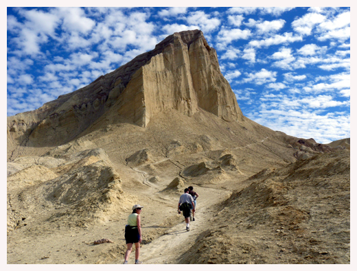
OK. Looks like nobody is going to guess this one. The mountain is Manly Beacon in Death Valley. Not the highest peak by a long shot, but one with an amazing story--told here with help from Wikipedia.
In 1849, at age 29, William Manly joined the thousands of American Forty-niners traveling to California to participate in the Gold Rush. He began traveling overland from Wisconsin.
Upon reaching the Green River, just west of South Pass, Manly and a half dozen other men tried to float to California by floating on an abandoned ferry they found down the Green to the Colorado River, then on to California. To fix the planking on the boat, they had to chop down trees and form the boards with their hand tools.
As had William Ashley done almost 25 years previously, they put in the river in Wyoming, and floated through the canyon of the Gates of Lodore. But, unlike Ashley, who disembarked at the mouth of the Duchesne River after experiencing the treacherous canyon, Manly may have traveled further down, to present day Green River, Utah where the Old Spanish Trail crossed the river.
Wherever they did disembark, they were met by Chief Walkara, who helped them to travel overland to the Wasatch Front. And this kindness was not forgotten by Manly. It was twenty years later, 1869, that John Wesley Powell's party was successful in floating further down the Green to the Colorado, then on to the California/Arizona border.
South of present-day Provo, Utah, Manly joined other Forty-niners traveling to southern California, including two families with small children. In December, these pioneers became lost in the Great Basin Desert, and entered Death Valley having followed an inaccurate map for three weeks. Remembering Chief Walkara's help, Manly argued strongly against raiding the Indian food caches that these 49ers found along the route, although his arguments were largely ignored.
Their food supplies were almost exhausted, and the oxen pulling their wagons were dying of starvation. The families stopped at Furnace Creek in Death Valley. They could go no further.
Manly, with his associate John Haney Rogers, trekked 250 miles on foot across the Mojave Desert to Rancho San Fernando near Los Angeles, California, to scout an evacuation route for the families trapped in Death Valley, and procure food and horses if a settlement could be located.
They arrived, nearly dead. But once in San Fernando, Manly took only two days to use the funds to buy supplies, and then hiked back the 250 miles to Furnace Creek to rescue the remaining members of his party. Once he got to Furnace Creek, he gave the group only a few days to prepared, then led them BACK over that same 250 mile route to safety.
Manly himself had hiked 750 miles over the most torturous terrain in North America on a mission of mercy to rescue the families at Furnace Creek. While a couple of the older men in the party died, Manly managed to rescue all of the women and children.
Manly Beacon is a tall white mountain that projects out above Furnace Creek near Zabrisky Point, and so it served as his guidepost to find the families he had left there.
In the compilation of his memories, Manly contacted all the relevant persons possible, then with the aid of a publishing assistant wrote the greater part of his autobiography, "The Death Valley in '49," published as a book in 1894. The title was changed to "Death Valley in '49," ostensibly to encourage sales, although Death Valley is only spoken of in the tenth chapter.
The book is an excellent read. In it, Manly recounts how, as the Bennett and Arcane families began their climb out of the valley through the Panamint mountains south of Telescope Peak, someone in the group, probably Sarah Ann Bennett (née Dilley), or Mrs. J.B. Arcane, turned to take a last look eastward and said "Goodbye, Death Valley!"
Mrs. Bennett, upon her death bed many years later, sent word to William Manly that she would like to see him once again before she died. He immediately left Southern California to race northward and was able to visit with her just a day before her death in San Jose. She always called him the Guardian Angel of her children.
Our long-time Sponsor, BackcountryGear.com - The leading source for ultralite/lightweight outdoor gear:
Affiliate Disclaimer: This forum is an affiliate of BackcountryGear.com, Amazon.com, R.E.I. and others. The product links herein are linked to their sites. If you follow these links to make a purchase, we may get a small commission. This is our only source of support for these forums. Thanks.!


 Previous Topic
 Index
Index


