#195732 - 06/10/1604:52 PMRe: Name this spot!
[Re: OregonMouse]
ndsol
member
Registered: 04/16/02
Posts: 678
Loc: Houston, Texas
Originally Posted By OregonMouse
Very wild guess on ndsol's picture--the Chinese Wall? If so, Montana, Bob Marshall Wilderness. I've only seen this from way, way back--haven't backpacked tere. So, as I said, a very wild guess!
Need to go further north. The photo is looking south and that is the Continental Divide in the photo. Similar to the Grand Tetons, the photos of the Chinese Wall would be taken from the east side. This photo was taken on the west side.
Granite Park Chalet along the Highline Trail in Glacier? Looks like Glacier Nat'l Park, and I remember a couple backcountry chalets there. I got an excellent peanut butter sandwich (with a pickle on the side!!!) at the Sperry Chalet, but I'm going with Granite Park for this pic.
#195737 - 06/10/1608:29 PMRe: Name this spot!
[Re: bobito9]
ndsol
member
Registered: 04/16/02
Posts: 678
Loc: Houston, Texas
Originally Posted By bobito9
Granite Park Chalet along the Highline Trail in Glacier? Looks like Glacier Nat'l Park, and I remember a couple backcountry chalets there. I got an excellent peanut butter sandwich (with a pickle on the side!!!) at the Sperry Chalet, but I'm going with Granite Park for this pic.
That's it! One of the two backcountry chalets in Glacier NP.
Had been on the trail for a week at this point and the next morning, just had to go over Swiftcurrent Pass (which is to the left) and then back down to get back to our starting point at Many Glacier. As this trip was late in the season, Granite Park Chalet was closed.
Ok, let's see if THIS photo turns out ok This is a classic Sierra peak above a classic Sierra lake on a classic Sierra loop...or if you prefer, along a classic Sierra through-hike!
Dang! I tried downloading the photo directly from my computer but the file was too big and I don't understand how to compress it. Meanwhile my copy of the photo that I put in my G oogle Photos seems to only share as a file link, not an actual photo. Sorry to make it hard to view.
Ok, let's see if THIS photo turns out ok This is a classic Sierra peak above a classic Sierra lake on a classic Sierra loop...or if you prefer, along a classic Sierra through-hike!
ok, I'll try again. Again, this is a classic Sierra peak above a classic Sierra lake on a classic Sierra loop...or if you prefer, along a classic Sierra through-hike. [img]https://goo.gl/photos/qsXDaQwkAECTu6KW7[/img]
...by the way, this is suppose to be a link to one single photo. Please let me know if anything is amiss, or if all my photos show up somehow!
Please forgive me, I'm trying to teach myself how to do this. I really want a photo here, not a link, and it's hard to experiment without cluttering this thread up https://goo.gl/photos/qsXDaQwkAECTu6KW7
#195760 - 06/11/1606:14 PMRe: Name this spot!
[Re: bobito9]
ndsol
member
Registered: 04/16/02
Posts: 678
Loc: Houston, Texas
Originally Posted By bobito9
ok, I'll try again. Again, this is a classic Sierra peak above a classic Sierra lake on a classic Sierra loop...or if you prefer, along a classic Sierra through-hike. [img]https://goo.gl/photos/qsXDaQwkAECTu6KW7[/img]
...by the way, this is suppose to be a link to one single photo. Please let me know if anything is amiss, or if all my photos show up somehow!
I think that is Painted Lady above Upper Rae Lake, which can be seen on the Rae Lakes Loop. A route I have always wanted to do and have looked at a number of times, but have never been able to pull it off.
#195763 - 06/11/1607:45 PMRe: Name this spot!
[Re: ndsol]
wgiles
member
Registered: 05/19/14
Posts: 182
Loc: Central Illinois near Springfi...
If it is the highest point east of the Mississippi River, that would be Mt. Mitchell in North Carolina, the peak of which has an observation deck. It's been a while since I was there, but the gnarled trees are familiar.
If it is the highest point east of the Mississippi River, that would be Mt. Mitchell in North Carolina, the peak of which has an observation deck. It's been a while since I was there, but the gnarled trees are familiar.
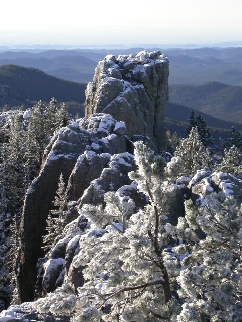
That was my first thought , but the trees on Mitchell are hemlocks It's Mt. Harney, South Dakota. Looks like a cool area. Have to do more research.
#195775 - 06/12/1607:25 PMRe: Name this spot!
[Re: bluefish]
ndsol
member
Registered: 04/16/02
Posts: 678
Loc: Houston, Texas
Originally Posted By bluefish
Originally Posted By wgiles
If it is the highest point east of the Mississippi River, that would be Mt. Mitchell in North Carolina, the peak of which has an observation deck. It's been a while since I was there, but the gnarled trees are familiar.
That was my first thought , but the trees on Mitchell are hemlocks It's Mt. Harney, South Dakota. Looks like a cool area. Have to do more research.
Mt. Harney it is! Highest point east of the Rockies. This was an early morning hike after it had snowed overnight in September.
#195778 - 06/12/1610:01 PMRe: Name this spot!
[Re: bluefish]
ndsol
member
Registered: 04/16/02
Posts: 678
Loc: Houston, Texas
Originally Posted By bluefish
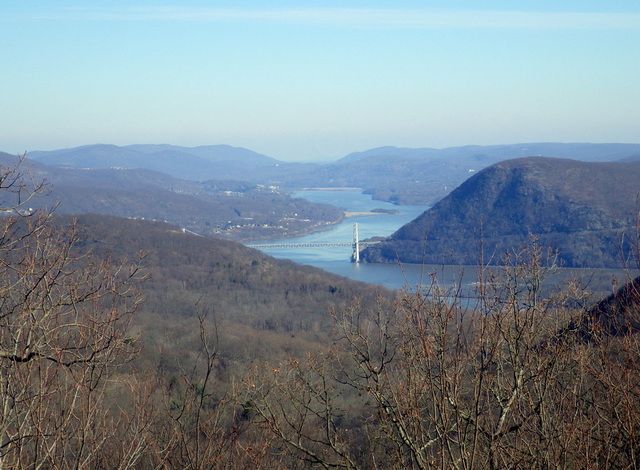
This bridge is well known in long distance backpacking. For extra points, name the park I took the picture from.
nd, that is a beautiful shot of Mt. Harney, really makes me want to visit. Thanks.
Thanks.
I first thought that this was Bridge of the Gods where the PCT crosses the Columbia River between Oregon and Washington, but now I don't think that is the case.
Bear mountain bridge over the Hudson River. I think that's Anthony's Nose on the other side, so I'm going to say seen from the Bear Mountain State Park. Maybe from Bald Mountain? Or from West Mountain? One of the two I think...
Scratch hits it out of the park, or in the park as the case may be. I took the picture from the Timp, Scratch. We had gone over Bear Mt. , through Doodletown and stayed at the West Mt. shelter. Next morning I took it after going down off of West and up the Timp. So in Harriman, rather than Bear Mt. We did about 200 miles in Harriman/Bear Mt. last winter. We had a great time doing it. 2 and 3 day trips. We spent New Years at one of the shelters. All yours, Scratch, glad to see someone who knows the same areas. Bear Mt. does include Dunderberg, Bald and part of the Timp, we were within a quarter mile from the line. You get the extra points, too.
Re Bluefish, sounds like a nice new years! I always get confused about where exactly the boundary between the parks is and just refer to them both as Harriman/Bear Mt State Park. I just did a day hike from that same area a couple of months ago so the view looked familiar.
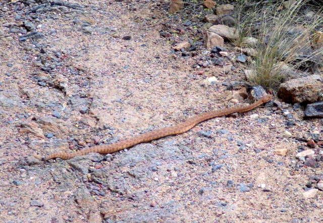
Unfortunately, I haven't done many of the easily identifiable hikes in this part of the country, so I'll go further afield. This might be too easy, but name this trail, probably the first or second most famous in the area:
It is the Grand Canyon, but on the Tonto Trail about 5 miles off the Bright Angle Trail. We were camped at Indian Gardens and I hiked the Tonto trail to the west.
Our long-time Sponsor, BackcountryGear.com - The leading source for ultralite/lightweight outdoor gear:
Affiliate Disclaimer: This forum is an affiliate of BackcountryGear.com, Amazon.com, R.E.I. and others. The product links herein are linked to their sites. If you follow these links to make a purchase, we may get a small commission. This is our only source of support for these forums. Thanks.!


 Previous Topic
 Index
Index


