Yep, the dwelling is Betatakin. There's another one in better condition that's requires a 17 mile RT backpack, called Keet Seel.It's a pretty cool canyon hike with a desert waterfall. We had planned to do it this Spring, but my wife was a little under the weather, so we saved it for next year. They also have a nice campground that's free. Worth a visit. All yours, Scratch.
#195889 - 06/21/1607:18 PMRe: Name this spot!
[Re: Rick_D]
OregonMouse
member
Registered: 02/03/06
Posts: 6800
Loc: Gateway to Columbia Gorge
OK, here's the photo I was previously unable to retrieve off my old closed flickr account:
For a hint, it's in my home state, but a long way from the Portland area. As you can tell from the vegetation, it's not on the wet west side of the state.
aimless was there at the same time I was, although we never crossed paths. I hope he'll hold off a little to see if someone else recognizes it.
Sorry to have two running at the same time; please specify if you're answering mine or scratch's!
Edited by OregonMouse (06/21/1607:41 PM)
_________________________
May your trails be crooked, winding, lonesome, dangerous, leading to the most amazing view--E. Abbey
Is that Rainier with the Winthrop Glacier in front? I think that's where I've seen the "subway tunnel" with the river emerging from it. I haven't seen it frozen up though. Nice pic regardless.
#195891 - 06/21/1607:51 PMRe: Name this spot!
[Re: bobito9]
OregonMouse
member
Registered: 02/03/06
Posts: 6800
Loc: Gateway to Columbia Gorge
Looks too peaky to be the North side of Mt. Rainier. The only ice caves I've heard of on Rainier are the long-defunct Paradise ice caves. They also don't look like photos I've seen of the Sandy Glacier ice caves on Mt. Hood (which also have collapsed as the glacier has shrunk). Not being a mountaineer, I don't get that close to glaciers. Lots of other ice caves in the NW, but none that I know about in glaciers.
I even tried googling.... I'm curious!
Edited by OregonMouse (06/21/1607:53 PM)
_________________________
May your trails be crooked, winding, lonesome, dangerous, leading to the most amazing view--E. Abbey
It actually is the Sandy Glacier Caves on Mt. Hood. This was taken around Thanksgiving last year (2015). My brother, who lives in Portland, had gone in 2014 and when we went in 2015 he said the caves were unrecognizable. I'm sad to hear they are completely collapsed now, although I suppose it was inevitably going to happen pretty quickly.
Anyway, since you guessed it OM and already have a photo up, I suppose we are back to one at a time. At least it will make things less confusing!
#195894 - 06/22/1612:18 PMRe: Name this spot!
[Re: scratchtp]
OregonMouse
member
Registered: 02/03/06
Posts: 6800
Loc: Gateway to Columbia Gorge
Reposting my entry, in case of confusion:
Quote:
For a hint, it's in my home state, but a long way from the Portland area. As you can tell from the vegetation, it's not on the wet west side of the state.
aimless was there at the same time I was, although we never crossed paths. I hope he'll hold off a little to see if someone else recognizes it.
I'll post another hint tonight (giving the original 24 hours for someone to guess).
Edited by OregonMouse (06/22/1612:22 PM)
_________________________
May your trails be crooked, winding, lonesome, dangerous, leading to the most amazing view--E. Abbey
#195903 - 06/22/1611:50 PMRe: Name this spot!
[Re: OregonMouse]
OregonMouse
member
Registered: 02/03/06
Posts: 6800
Loc: Gateway to Columbia Gorge
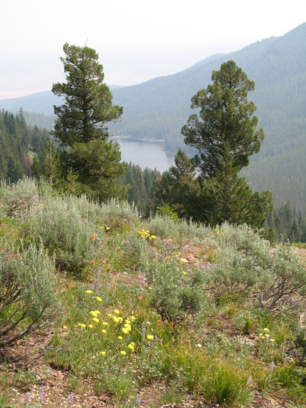
Hint #2: The lake is more or less north of where I took the picture; this is an easterly view from a little farther up the same trail:
Hint #3--to reach this place from Portland, you drive east about 6 hours on a US highway that starts near Seaside, OR, goes through Portland, follows the Snake River to Jackson Hole and ends up following the Oregon Trail route to the highway's end in Ogalalla, NB. The mountains and lake in the photo are south of this highway.
Surely somebody on this board has been there!
Edited by OregonMouse (06/22/1611:53 PM)
_________________________
May your trails be crooked, winding, lonesome, dangerous, leading to the most amazing view--E. Abbey
#195912 - 06/23/1610:51 PMRe: Name this spot!
[Re: OregonMouse]
OregonMouse
member
Registered: 02/03/06
Posts: 6800
Loc: Gateway to Columbia Gorge
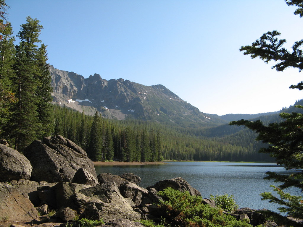
The lake shown in the first photo, taken from the north end of the lake looking southish to where photos #1 and 2 were taken.
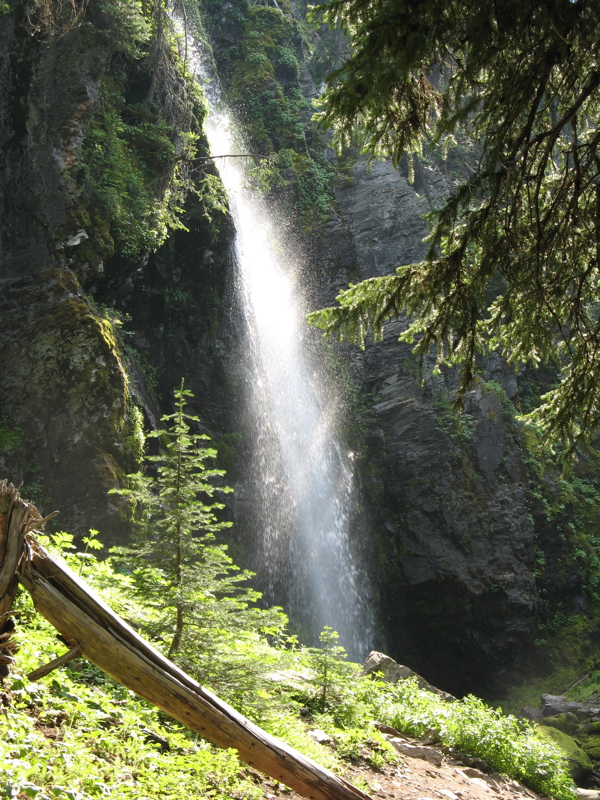
The ridge at the very far right, next to the right margin of this photo, is where photos #1 and 2 were taken. That trail climbs to the top of the highest peak in this mountain range (not in the photo). Before the trail starts climbing that mountain (same name as the lake), it passes this lovely waterfall. And, you guessed it, the waterfall has the same name as the lake and the mountain. No, I have no photos of the mountain.
Should be very well known to Oregonians and many Washingtonians, and I know we have several on this forum. Aimless, if you're here, feel free!
_________________________
May your trails be crooked, winding, lonesome, dangerous, leading to the most amazing view--E. Abbey
#195916 - 06/24/1612:39 AMRe: Name this spot!
[Re: JustWalking]
OregonMouse
member
Registered: 02/03/06
Posts: 6800
Loc: Gateway to Columbia Gorge
You got it! The Strawberry Mountain Wilderness, containing Strawberry Lake, Strawberry Mountain, Strawberry Falls and several other lakes (not named Strawberry), is just south of Prairie City, a few miles east of John Day, OR on US highway 26. Quite a bit of it burned last summer--in fact, Prairie City had to be evacuated--but fortunately not this section. It's great for early July hikes as it melts out sooner than the Wallowa Mountains farther east, or the high Cascades. The long drive from Portland keeps it from being overpopulated.
JustWalking, it's now your turn to post a photo!
Edited by OregonMouse (06/24/1611:31 AM)
_________________________
May your trails be crooked, winding, lonesome, dangerous, leading to the most amazing view--E. Abbey
#195926 - 06/25/1604:28 PMRe: Name this spot!
[Re: JustWalking]
OregonMouse
member
Registered: 02/03/06
Posts: 6800
Loc: Gateway to Columbia Gorge
OK, so we are evidently open to anyone who wants to post a "Name this Spot" photo! Unless there's a way I don't know about to post a photo here directly from one's computer, so JustWalking can post one.
Edited by OregonMouse (06/25/1604:34 PM)
_________________________
May your trails be crooked, winding, lonesome, dangerous, leading to the most amazing view--E. Abbey
I'll go ahead and post one, but if someone else wants to, they're welcome to take over.
Moving to the East Coast for this one, this photo is from a relatively popular waterfall in its area, which also serves as a spot for ice climbers in the winter.
#195945 - 06/26/1605:45 PMRe: Name this spot!
[Re: scratchtp]
billstephenson Moderator
Registered: 02/07/07
Posts: 3917
Loc: Ozark Mountains in SW Missouri
Makes me chilly just lookin at it
I think this is going to be pretty tough on the western crowd here. I've never backpacked at all out East so I'm clueless as to what the popular spots might be, but that spot is certainly beautiful and I'd love to roam around there for as long as I could.
I'll give a hint then, and another picture. (As a side note, I'm curious what the ratio of members from the West Coast to everywhere else is on this forum).
This picture is taken within a few miles of the other one, from an AMC hut towards a mountain that also is known for climbing, in the winter and the summer.
You have the right area (right mountains, right state), but not quite the right falls. This area is closer to the interstate to the west. The first picture is on one side of the interstate, while the picture of the hut is on the other. I'll accept the identification of the AMC hut as well.
Here's another picture taken from the AMC hut looking to the East.
#195981 - 06/29/1605:54 PMRe: Name this spot!
[Re: scratchtp]
billstephenson Moderator
Registered: 02/07/07
Posts: 3917
Loc: Ozark Mountains in SW Missouri
I haven't had time to look into it more. It's been my intention to try but I was hoping a few others would take a crack since you said I was close. I think we should try a bit more to nail it down first
Galehead hut? I've done a winter summit of Washington and fooled around on some slabs off the Kancamagus, but have spent little time in the Whites. I plan to do a backpack on Moosilauke this summer.
At this point I can't modify my post, but if it's offensive in some way, consider it ineligible and removed. Scratch, just give it to Bill so we can move on (I'm out from now on, but still have interest in seeing others picks)
Our long-time Sponsor, BackcountryGear.com - The leading source for ultralite/lightweight outdoor gear:
Affiliate Disclaimer: This forum is an affiliate of BackcountryGear.com, Amazon.com, R.E.I. and others. The product links herein are linked to their sites. If you follow these links to make a purchase, we may get a small commission. This is our only source of support for these forums. Thanks.!


 Previous Topic
 Index
Index


