#195566 - 05/30/1609:33 AMRe: Name this spot!
[Re: bobito9]
ndsol
member
Registered: 04/16/02
Posts: 678
Loc: Houston, Texas
I think Pyramid Peak has to be it as it is close to 10,000' (the reference to being 16' short) and in the Desolation Wilderness, which is near Lake Tahoe, but it looks somewhat different.
I'd like to know where the egret was. A wetland area? I think Bobito has it. Never been, but certainly worth it, after doing some research. I'm enjoying this post; learning new areas and great places. It's not a contest, it's a sharing, learning thing. Cool.
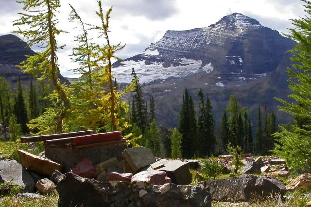
Ding-ding-ding, Pyramid it is. View is from the northwest in the cirque comprising the Lyons Creek headwaters, so a different angle than typical.
The egret (typed ibis earlier--duh) was taken on the valley floor, near Walnut Grove and the Cosumnes River, almost a hundred miles away. Most days the murk cloaks Crystal Range viewing from the valley.
And with that I relinquish the helm (spot the mixed metaphor).
cool! I'm just lucky: Rick picked a pyramid. Thankfully it wasn't a decahedron or dodecahedron. I really suck at advanced geometry. I'll post a new contest photo soon.
[img]file:///home/chronos/u-db1fdf0c41daba6c7d3b7840dba72534791d2603/Downloads/world's%20most%20scenic%20toilet[/img] Does this link work? Anyhow, a hint: we've left the Sierra Nevada, and I'm looking for the place, not a name of a mountain. And I'm sure that, if you've ever spent some time in contemplation here, you will remember it
well, that's utterly screwed up! Didn't even get the photo posted and it gave it away. Nice photo, too. I have my own of it that I took but I don't have an easy way to post it. Sahale Glacier outhouse. I'm going to take a sabbatical from this game.
#195579 - 05/30/1608:25 PMRe: Name this spot!
[Re: bobito9]
ndsol
member
Registered: 04/16/02
Posts: 678
Loc: Houston, Texas
Originally Posted By bobito9
well, that's utterly screwed up! Didn't even get the photo posted and it gave it away. Nice photo, too. I have my own of it that I took but I don't have an easy way to post it. Sahale Glacier outhouse. I'm going to take a sabbatical from this game.
Well I hope to use it this summer if our Scout group is able to secure the permits. Dayhiked up the arm in 2014, so haven't seen the facilities there yet.
ndsol
member
Registered: 04/16/02
Posts: 678
Loc: Houston, Texas
Originally Posted By wandering_daisy
For the sake of a bit more fairness, since this forum includes areas throughout the country, if you identify the photo then try to put up a photo of a different area/mountain range/state. Otherwise, I can see this devolving into an ever narrowing puzzle only solvable for those who happen to backpack in a single range.
Let's move away from the West Coast. Not wanting Wandering Daisy to continue to feel that she is being left out, she will get this one without hesitation:
#195594 - 05/31/1608:03 PMRe: Name this spot!
[Re: ndsol]
OregonMouse
member
Registered: 02/03/06
Posts: 6800
Loc: Gateway to Columbia Gorge
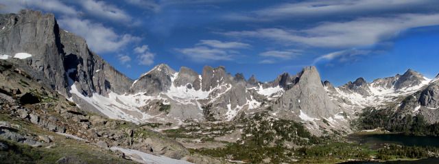
This one is pretty obvious My only experience of this place was from the "back side" but I've seen tons of photos of this side! The funny looking cone shaped peak in the middle is Pingora and, of course, this is the Cirque of the Towers at the south end of Wyoming's Wind River Range.
Here's a shot in the same general area: Hopefully W_D can identify the peaks!
_________________________
May your trails be crooked, winding, lonesome, dangerous, leading to the most amazing view--E. Abbey
What is referred to as the "back side" of the Cirque of the Towers. I sort of consider this also a part of the Cirque of the Towers, at least the Towers part! New York Pass on left, Bollinger Peak, and the other towers Block, Sharksnose. The lake is Shadow Lake.
#195708 - 06/08/1605:22 PMRe: Name this spot!
[Re: OregonMouse]
ndsol
member
Registered: 04/16/02
Posts: 678
Loc: Houston, Texas
Originally Posted By OregonMouse
I already posted one above, along with hints! Hint #2 is that it's not in the Cirque.
It may not be "in the Cirque", but it is the backside of it from Shadow Lake. That is Wolf's Head on the left and Shark's Nose on the right. We were supposed to do that route via Texas Pass out of the Cirque, but the snowpack was still way too high, so we retreated the way we came in.
ndsol- go ahead and your turn. My computer is getting serviced (against my wishes I was upgraded to Windows 10, then Photoshop would not work, etc. The photo I wanted to use is on that computer. I should get it back in a few days. I will do my turn then.
ndsol
member
Registered: 04/16/02
Posts: 678
Loc: Houston, Texas
Originally Posted By wandering_daisy
ndsol- go ahead and your turn. My computer is getting serviced (against my wishes I was upgraded to Windows 10, then Photoshop would not work, etc. The photo I wanted to use is on that computer. I should get it back in a few days. I will do my turn then.
Staying in the Rockies, but north of Wind River, name the structure in this photo:
I'll take a gander at it. I'll go with grand canyon and the angel trail. I haven't actually been on many of the trails there since I was only there for a day and a half, but it doesn't look quite how I remember the south Kaibab trail looking.
Pic One is the Horn Creek Drainage, probably 1/2 mile NE of the campsite. I can't quite place pic 2. Scratch, if you went to Plateau Point from the Bright Angel you could look west towards this area. It's a few miles west from Indian Garden on my favorite trail, the one and only Tonto. I just love traversing that canyon on that platform. It's the next drainage west where you really need to watch your feet in places. The Inferno made me sweat, worrying how my wife would handle the slanted exposed trail, She went through it just fine. Trekking poles. Godsends. WD could walk backwards, blindfolded through it; we're mere old mortals.
#195731 - 06/10/1604:42 PMRe: Name this spot!
[Re: ndsol]
OregonMouse
member
Registered: 02/03/06
Posts: 6800
Loc: Gateway to Columbia Gorge
Very wild guess on ndsol's picture--the Chinese Wall? If so, Montana, Bob Marshall Wilderness. I've only seen this from way, way back--haven't backpacked tere. So, as I said, a very wild guess!
Edited by OregonMouse (06/10/1604:44 PM)
_________________________
May your trails be crooked, winding, lonesome, dangerous, leading to the most amazing view--E. Abbey
Our long-time Sponsor, BackcountryGear.com - The leading source for ultralite/lightweight outdoor gear:
Affiliate Disclaimer: This forum is an affiliate of BackcountryGear.com, Amazon.com, R.E.I. and others. The product links herein are linked to their sites. If you follow these links to make a purchase, we may get a small commission. This is our only source of support for these forums. Thanks.!


 Previous Topic
 Index
Index


