Lori mentioned there are methods to account for not taking a direct route to a destination. This brainteaser will help a person learn these methods. The first time it can be done on a piece of paper. Then in a big open area using vectors of your choice. A protractor would be real handy so you don't have to orient the map each time.
Your destination is 1,000 feet straight north of your current position.
Due to simulated obstacles, you have to walk the following distances and headings:
ringtail
member
Registered: 08/22/02
Posts: 2296
Loc: Colorado Rockies
Originally Posted By Gershon
If I were to teach navigation, I'd start with dead reckoning in an area where bushwacking is easy. I'd lay out a series of points and ask the person to navigate from one to the next using just a compass and pacing. They wouldn't have a map, so topographical features would be useless.
The next step would be to start from a known point and map a trail using dead reckoning.
By this time they will be ready for a Topo map.
If you are talking air or sea navigation then maybe using the compass is a good starting point. Teaching map reading with a topo is the first skill I teach for LAND navigation.
_________________________
"In theory, theory and practice are the same. In practice, they are not." Yogi Berra
If I were teaching someone new to backpacking, I'd have to agree. Many won't go any further than that. Nor is it really necessary for a person who is going to stay on popular trails.
If the final goal advanced navigation, I'd still start with dead reckoning. One reason is it can be practiced simply in any big area. In the military, we started with dead reckoning and in survival school, we only used dead reckoning. We weren't given a map. Just a bearing and distance to the next checkpoint.
You have discovered a new trail that is not on the map. You know the exact starting point.
You and a friend decide to map it accurately using a piece of 550 line and amd two compasses. So you get 105'7 in of 550 line which is 0.02 miles.
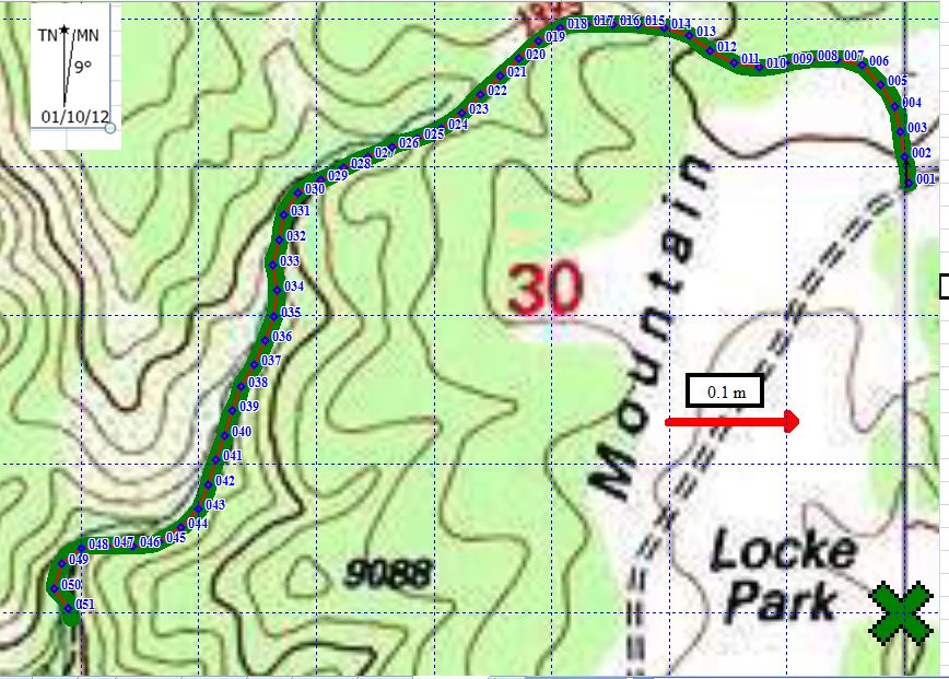
Since you are likely to do this on a marked trail, just have the learners plot the trail on a part of the map nearby where the trail isn't visible and compare shapes.(Like starting at the 'X' in the lower right corner.) With skillful use of Excel, it could be plotted very accurately.
Collect required data on the trail and plot the trail at home after.
Expect 4 errors. Failing to correct for variation. Correcting for variation the wrong way and the recipricol of those.
ringtail
member
Registered: 08/22/02
Posts: 2296
Loc: Colorado Rockies
Been there, done that. I remember a night compass course at Fort Carson in the late 60's. The military did not do a good job of teaching LAND navigation then. I have no reason to believe they do a better job now.
I have taught orienteering to elementary school students and they can learn to read maps before they learn geometry. You are better able to get the participation of the adult leaders if you emphasize map reading and NOT compass.
At orienteering competitions we are encouraged to set up a string course. Kids without reading or math skills can still read a map.
The next step is a course that can be completed without using a compass, but using a compass will shorten several legs.
I completed, but was not competitive, a half dozen advanced orienteering course one year without a compass.
Vector navigation should be one of the tools in your navigation tool box, but it is not the most used technique.
I think the easiest and most effective training is to set up a memory navigation course. At each control there is a map with the next control marked. You can set a compass bearing and measure the distance, but you also need to visualize the terrain. You then need to travel to that control with only your memory. Make it a timed event and it gets interesting.
Edited by ringtail (01/10/1211:44 AM)
_________________________
"In theory, theory and practice are the same. In practice, they are not." Yogi Berra
One of the reasons I like doing a lot of seemingless useless exploration is sometimes I discover something useful. If I line up the compass just right on the sun, then I can use it easily as a sundial. The north arrow is the hour hand. Since my variation is 8.5 degrees, it's off by 2 minutes from local noon. I haven't figured it out yet, but it can also be used as a sextant.
billstephenson Moderator
Registered: 02/07/07
Posts: 3917
Loc: Ozark Mountains in SW Missouri
Quote:
You and a friend decide to map it accurately using a piece of 550 line and amd two compasses
Is 550 line like Mason's String Line?
I think that could be fun using those tools. But I think I'd have them plot the trail on the map while they went along. You could also give them a piece of paper to note their readings on and let them enter that into an excel SS when they get back. Then you could let them compare the map they made with what the program plotted using their notes, and a GPS route of the trail using waypoints set at the same interval as the line length.
I found this online demo that is interesting. It's too bad they don't give you better access to it, but what they do provide is well presented. I played with it for a few minutes and had fun with it. Might go back and play some more
billstephenson Moderator
Registered: 02/07/07
Posts: 3917
Loc: Ozark Mountains in SW Missouri
Quote:
I haven't figured it out yet, but it can also be used as a sextant.
I never thought of that, but it should work.
I'd guess you turn it sideways, hold it level, point the line on the outer ring at the sun, count the number of degrees from O the line points to, and that's the angle of the sun.
I think The Old Farmer's Almanac has those numbers for sale for your location. They have an online app that will make them and send them to you for the entire year (for one location). It's handy for designing buildings to take advantage of solar gain.
I never thought of the sundial trick either, thanks for those cool tips!!
I went outside to practice mapping a trail using just dead reckoning. It's a lot tougher than it looks. Just getting a good bearing is difficult with the glare on the compass. It would be better to have a tape measure for those legs that are curved a lot. I used Excel to plot the vectors as it's just easier. With a lot of care and 40 minutes I came out dead on for 700 feet.
Then the compass was pointing 90 degrees off on the corner. Something is there. Aliens maybe? More likely some electrical field.
If you're serious about map/compass/land navigation using a lensatic compass, the first thing you need to do is ditch that cheap Cammenga replica and get a real one.
They have links to online data, software, and books there. I think you can get the data for your location for a 24 hour period.
I still don't know all the steps to fix your lat/long using a sextant, watch, and those tables, but I would like to know and I'd like to try it out. It can't be that difficult, can it?
It is pretty difficult and takes a baby step learning process. In order to be prepared to take fixes, you would need the HO tables. I think they are made by the Naval Observatory.
There are corrections that need to be made for altitude and also times near sunset and sunrise. They used to be online, but I can't find them now.
skcreidc
member
Registered: 08/16/10
Posts: 1590
Loc: San Diego CA
Quote:
If you're serious about map/compass/land navigation using a lensatic compass, the first thing you need to do is ditch that cheap Cammenga replica and get a real one.
I think Gerson's compass is probably just fine. He can check it out for accuracy is he wants. I spent years using THIS
and now I usually carry a $12 special that works fine for general navagation. I think Ringtail said it first, but usually I just use the map. If I am serious about navagating, I take the Brunton. And that is because I already have one anyway, so why not use it.
sK
Just a side note, a longer needle is more accurate. But you will notice that they don't make a compass as large as a dinner plate. At least I don't think so.
Our long-time Sponsor, BackcountryGear.com - The leading source for ultralite/lightweight outdoor gear:
Affiliate Disclaimer: This forum is an affiliate of BackcountryGear.com, Amazon.com, R.E.I. and others. The product links herein are linked to their sites. If you follow these links to make a purchase, we may get a small commission. This is our only source of support for these forums. Thanks.!


 Previous Topic
 Index
Index


