Well, I guess a complete trip report is in order. So here is the "rest of the story" with a few more photos.
Wind River Indian Reservation Loop Trip from St. Lawrence, 2009
July 27. My husband and I left Lander the afternoon in a deluge! The weather report forecast snow. Knowing that the dirt road to St. Lawrence trailhead turns to a quagmire, I was worried. Thankfully we drove north faster than the storm was moving. After a few tries to find the road, we turned off the highway and followed a very narrow cracked paved road that soon turned to a deeply rutted dirt road, a challenge in my little Toyota Corolla wagon. One drop into a rut would stop us. As the road switch backed upward ruts turned into sharp rocky gravel. Parts of the road were washed out, guardrails were absent. The views down to the North Fork of the Little Wind River were spectacular in the storm lighting. A few raindrops fell, but for the most part we escaped the storm. The road ended at the west end of St. Lawrence Basin near some old decaying wooden structures. We parked next to an SUV�s and set up our tent and watched horses grazing north of us. A signs that would verify that this was the trailhead was absent as is typical in the Wind River Indian Reservation Roadless Area.
July 28. We left our car at 8:00, and after a bit of wandering around, found a faint sign nailed to a tree and followed the 4wd road until it became a trail. The road was not located where shown on the USGS map, another quirk typical of the Reservation. After a mile going uphill the trail steeply dropped to South Fork of St. Lawrence Creek. My husband jumped rocks; I took off shoes and waded. Two more miles steadily heading uphill and we came to a trail junction with a sign that said �Twin Lakes�. No trail is shown on the map. We continued on the main trail, across a flat called �The Meadows�. Our packs were heavy and it had taken us 4 hours to get here. The trail again ascended quite steeply towards a pass south of Entigo Peak where we ran into a couple. We then dropped down to re-entering timber and crossed a creek (not shown on the map) until we reached a meadow and crossed Entigo Creek. On a tree with an empty whisky bottle on the ground, a weathered wooden sign was nailed, pointing the way to Raft Lake. We dropped packs and found a large established campsite a few hundred feet down the trail. We were not going to Raft Lake, but it was 3:00 and a storm was brewing. The campsite had constructed horseshoe pits! The clouds spit a bit but there was enough sunshine that I took a quick bath and then walked down the trail a quarter mile before it dropped down a steep hill. We had come 6 miles our first day in 7 hours. It rained at night.
July 29. We awoke to cold and thick fog and left at 8:40. We returned to the whiskey bottle and continued due west on a well used trail. The trail did not always coincide with its location shown on the map and many spur trails were confusing. The dense fog did not help either! Light rain began. At one point we waded across the main creek only to re-cross trying to find the trail. Once found, we realized we had taken one of the many spur trails. Soon we again had to wade across the creek then ascended more steeply a few hundred feet before breaking out of the timber into a meadow. I took off shoes again and waded across the outlet of Enos Lake; my husband with a longer stride and leather boots was able to hop slightly submerged rocks. In retrospect we should have camped right here and gone fishing! Instead we went on to midway along Tigee Lake only to find marginal camping in the timber and ended up returning. The couple we had met yesterday was camped near the inlet to Enos Lake. The clouds were turning darker. At 3:00 we ended up caught in rain and hunkered under trees, getting soaked and chilled � I had not been this cold in years. We managed to get our tent set up at 4PM. It briefly cleared but I was not able to cook the entire dinner before it began raining again. Everything was wet and we were discouraged. We had hoped that this short 3-mile day would leave plenty of time to fish. I could not believe we took seven hours to get here and did all that back tracking!
July 30. We were blessed with a clear frosty morning. We returned to Tigee Lake, left the trail and crossed the outlet. Again, I waded! We found a game trail up the ridge east of the drainage and soon reached the upper valley. Although there probably is a use-trail up the drainage, we decided to start uphill to avoid the swamp below and soon were jumping large talus blocks. Going was slow, but not hard. The ridge we were headed for was full of knobs. Although we could have avoided some elevation gain, we went straight south over the top and dropped into an amazing high meadow full of what appeared to be sheep poop. There certainly was good grass up here and many small snowmelt trickles. We dropped packs and scouted, finding a use-trail that descended steeply to the lip of a lower bench and then down to timber. We picked up another trail past Lake 10,465 where we found a nice campsite west of the outlet. We had only gone about 3.5 miles. The weather was great and we both went fishing- I fly fished downstream and my husband used spinners in the lake. We returned to camp and fried up a pan full of fish of all sizes. Yum!
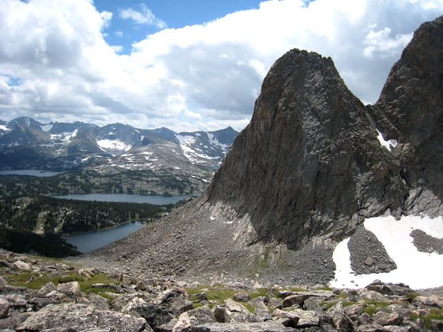
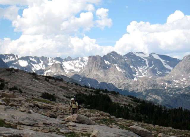
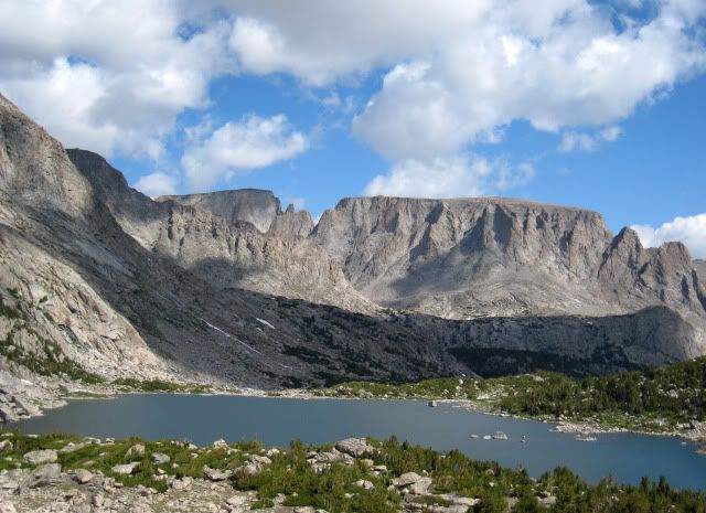
North Fork of the Little Wind River from Saddle Mountain Ridge
July 31. We left at 8AM, dropped on a trail to Lake Heebeecheeche and found a faint trail along the northwest shore to the inlet where we both had to wade across. We headed cross country east of the drainage to spectacular Spider Lake. It was again a clear blue sky. We traversed the lake on the east and south gradually ascending the southern inlet until we came to the seemingly impossible Odyssey Col. I had been over this pass before and knew it was quite easy. After a bit of talus hopping we began to climb low angle slabs and zig-zag up ledges to the top. The slabs are lichen covered so would be slippery in rain. The descent off the west side is a steep 600-foot drop on grassy ramps with beautiful miniature flowers. We crossed the main creek and found a nice campsite near Lake 10,935 at 2:30. Clouds had quickly built and it was too threatening to continue over Photo Pass. I went for a short walk. It rained hard at 4PM and we rested in the tent and read. It was another short but rewarding day.
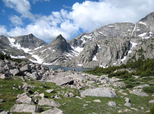
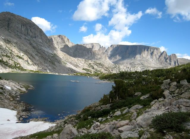
View towards Odyssey Col from Spider Lake
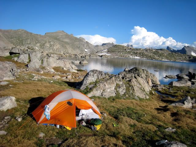
August 1. We awoke to frost and not a breath of wind. I quickly got up and ran down to the lake to catch some fantastic reflection photos. As I came back I noticed that the snow patches next to our tent were ice. Photo Pass was covered in snow and would be in deep shadows most of the morning. We only had trekking poles and decided to take an alternative route to Milky Lakes. We soon picked up the trail north of Middle Fork Lake and at about 10,700 feet we left the trail to traverse to Halls Lake following disconnected game trails. We passed lovely ponds and beautiful wildflowers and spooked several deer. I had been here in the 1970�s but had forgotten how beautiful and green it was. We went over a small pass and dropped down to the unnamed lake south of Halls Lake where we intersected a use-trail to the outlet of Halls Lake. We had to wade across the swift outlet stream. It was too early to stop. There are a few ways to get to Europe Canyon from Halls Lake. We chose to go up the inlet and then traverse past a few lakes. For a while, I cursed my choice- some difficult travel. As we reached Lake 10,806 my husband lost his mojo. I looked for a campsite only to find rocky windy sites. I twisted his arm to continue. We dropped down the drainage on a trail. Rather than drop to the small lake below I decided to head cross-country to Lake 10,542. Big mistake! It was not bad but my very tired husband wanted to drown me at this point. I had to do more arm twisting to continue to the outlet. Here we stopped and took a nice bath. After half hour rest he was in a more pleasant mood. I scouted for a campsite, finding a nice site on the saddle just northwest of the lake. Neither of us had Wyoming fishing licenses (we had Reservation permits) as we watched the fish swim in the lake! Some fishermen walked by hauling a good catch. We had eaten a bit of fish already, so declined the temptation. We had traveled over 8 miles, mostly off-trail.


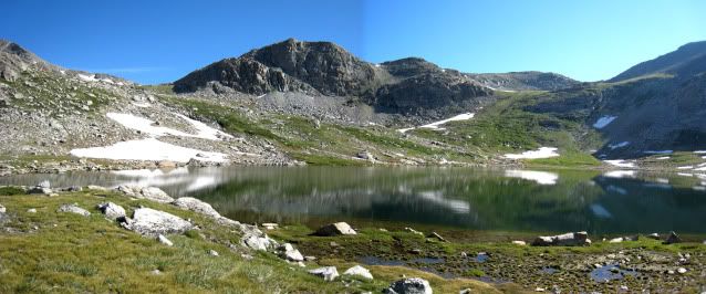
Morning Reflections
August 2. The goal was to reach the Milky Lakes via Europe Pass. We found a good use-trail along the northwest shore of Lake 10,542 that eventually intersected with the main trail. The upper lakes were full of medium sized fish and the scenery was lush grass and high peaks. The weather was perfect too! On the pass we stopped for lunch as we looked down on the Milky Lakes. The trail basically stops at the pass. We were back on the Reservation and legal to fish. In hindsight, we would have been better to traverse east to avoid the snow before descending; instead we simply dropped directly, getting into some sketchy steep snow. We stayed above the east shore of Lake 10,450 and dropped to Half-and-Half Lake, so called because the west half is on the Bridger Forest and the east half on the Reservation. There were game trails but no distinct path. The smart thing would have been to stop here and camp. We dropped down to the next lake getting ever into more brush and discovered there was no camping at all. Worse yet, my husband�s very expensive fishing rod had fallen off his pack. We slowly tried to find our exact path back to Half-and-Half Lake. Almost back to the outlet, I spotted the rod case. We were gloriously happy. After a little hunting around we found a very nice flat campsite on soft duff in an unusual saddle. We had traveled 7 miles when we could have gone 5 miles if we had the sense to stop here before our boondoggle. We set up camp and started fishing. I took a bath. After an hour we came up empty handed. My husband had snagged something on the bottom and I was determined to not lose the lure. I waded out over waist deep and was unable to find the lure so we had to cut the line anyway. This was the second cold bath of the afternoon! Later when back in Lander we talked to the federal Fish and Wildlife biologist. He said they regularly planted fish in the upper Milky Lakes and they seem to all swim downstream, preferring the lower lakes.
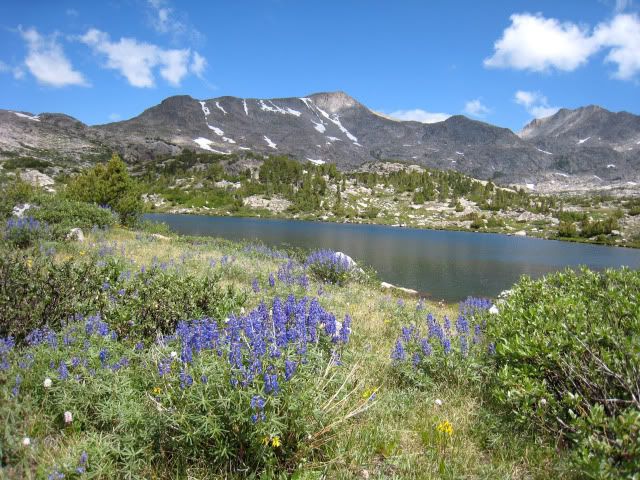
Upper Europe Canyon and Pass
August 3. I knew there were use-trails and game trails that lead north in this area and I was determined to find them. We planned to reach several beautiful lakes on the east flank of Milky Ridge where I had heard there was good fishing. I had been up and down Milky Ridge but not to these unnamed lakes. These lakes were only 2 miles as the crow flies to the east but the cliffs of Milky Ridge requires going north around the �nose�. The terrain is very complexly jointed rock with numerous small cliffs. Often we were on good game trails; sometimes we lost them. At one point we were rim-rocked and had to wade in the adjacent lake and hoist packs up on rocks. It was like going through an obstacle course, often tricked by what appeared to be a distinct use-trail, only to have it disappear. We finally got up on the nose of Milky Ridge and travel became quite easy. Clouds were building and by the time we reached the northernmost lake the sky was black. Other than Lake 10448, all are unnamed and campsites were very limited. We reached the south inlet of Lake 10,448 and the sky let loose. We quickly set up the tent on a mossy hummock and waited out the storm. I scouted for a better site when the rain eased. We found a nice spot on the west shore of the unnamed lake to the south. Then my husband went fishing. In half an hour he came back with two large trout and we feasted that night. The setting was pristine and panoramic � what a nice end to a 6-mile day over very rough terrain.
Rough travel getting to Milky Ridge
Easier travel traversing the north nose of Milky Ridge
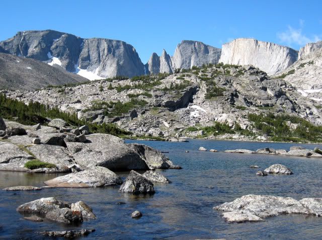
Unnamed Lake on the east bench of Milky Ridge
August 4. We now were to drop to the South Fork of Bull Lake Creek. I had heard that a direct descent down the drainage was short but pretty intense bushwhacking. While poking around the day before I found a use-trail heading south, so we left camp and followed it. Everything went smoothly until the trail simply disappeared at the lip of the bench. I suspect we should have traversed east at 10,600 elevation instead of dropping directly down a distinct but really steep game trail. At times we wished we were deer so we could better scoot through willows. We had to walk in the unnamed lake at 10,100 feet to avoid cliffs. We crossed the inlet to Lake 10,006 and took a rest. The USGS map shows an old trail about half a mile east. We headed east and found a distinct game trail that instead went down the ridge directly east of the drainage. We followed this fair trail to the South Fork at 9,380 feet where we found a wide swift stream that I did not think we could cross. Hoping to find a better crossing downstream, we headed north only to find things just got worse. So it was another back-track. Then we went upstream to no avail. We were both getting tired and cranky. Mosquitoes did not help. We returned to our original spot with an hour lost. This time we set foot in the swift water and found it was not as bad as we thought and got across. There are rock benches adjacent to the creek and we camped on a nice flat spot on one of these benches. I went upstream to fly-fish at a large meadow. Soon I was catching tons of 6-inch fish. Back at camp I took my rod down to the stream just below a big waterfall and cast out into the white water. When I brought back the line there was a fish on the end! I do not think there was any place here where you could not catch a small fish. There is supposed to be great fishing at Deadman Lake but we felt like �dead men� and had no energy to walk down there. We had only traveled 5 miles but they were exhausting miles. We built a nice fire and cooked a pan full of our tiny fish.
August 5. There are two routes to Paradise Basin from the South Fork; an unmarked but locally maintained trail not shown on the map that traverses the north nose of Windy Ridge or a no longer maintained trail over Windy Gap. I had been over Windy Gap 40 years earlier and hoped that we could traverse Windy Ridge eastward and drop back into Wilson Creek Lakes, this time to get in some fishing. The hardest part of this trail is to find it at the bottom, since it is not used much and has become very overgrown in the thick timber and brush. It took us half an hour and many detours to finally find it, and glad we were that we did! It soon heads steeply uphill and it was now imperative to be on the trail. It was amazingly distinct and in good shape. We briefly lost the trail at about 10,300 feet instead following a game trail that thankfully quickly intersected the trail. As we looked up the South Fork we could see the beautiful green meadows and meandering stream. Near the top of the steep switch backs long posts in the distance marked the way to Windy Gap. As we peered down at Hatchet Lake, clouds were becoming threatening. We opted to drop down instead of traversing to Wilson Creek Lakes, reaching an established campsite near the outlet of Hatchet Lake. Our short day of only 4 miles would mean a longer day tomorrow, but we knew fishing was good here. My husband went fishing and I opted to take a bath and wash my hair. Soon he came back with three fat fish from 12 inches to 8 inches. We again feasted. As dusk neared we went into the tent. A nearby yearling black bear must have also realized we feasted on fish and soon we had an uninvited guest nearly sticking his nose in the tent door. My husband remarked he had never seen bear snot before. We clapped hands and banged pots; he left. In half an hour he was back. By now my dear husband had fallen asleep and waking him is nearly impossible. I got out of the tent barefooted and picked up my trekking poles and banged and cussed at the bear and he ran off. Dear husband, my defender, never awoke. It started to rain and if the bear did come back neither of us noticed.
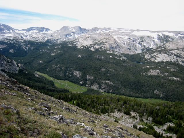
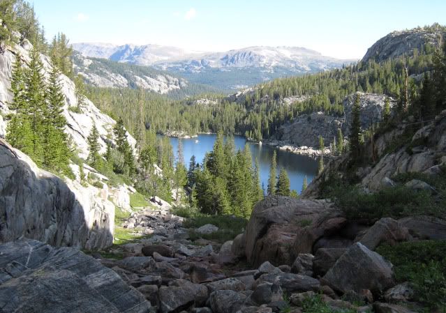
View of the South Fork of Bull Lake Creek

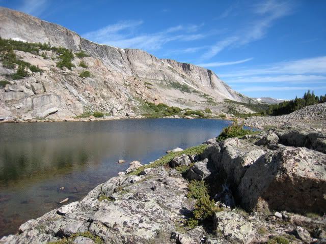
Hatchet Lake
August 6. From Hatchet Lake the trail is fairly good. We never found the bridge that is marked on the map. Either we got off the trail and missed it or it has been long washed away. We passed Steamboat Lake and all the meadows shown on the map were now ponds. At beautiful Lydle Lake we stopped for lunch. Soon we reached Paradise Basin where we had planned to camp. Reservation packers, a man and young woman, came down the trail-a very picturesque site galloping towards us with their dog trailing behind. They said they were bringing in food for a party at Steamboat Lake who had lost all their food to a bear. Umm? Was that our bear? We had a bear canister that he played with for a while. He seemed more interested in playing than eating; maybe he was full of the other�s food! We decided it was early enough to go up over the pass so headed uphill. As we dropped down the east side we decided to camp at the edge of timber near a little creek at about 10,400 feet. After our 8-mile day we set up the tent and then just sat out in the tall grass and enjoyed the sunshine. Soon my husband saw animals in his binoculars. He handed the binoculars to me- they were elk. It was dusk and we watched the elk, totally surprised that soon literally hundreds of elk were moving off the slope into the timber for night. Soon people walked up into our camp. A scout troupe was camped just below us and they said they come here every year just to see the elk.

Paradise Basin
August 7. We headed down the trail through thick timber along the gurgling creek. In about 5 miles we reached the northwest edge of St. Lawrence Basin where we saw the parked vans used to transport the Boy Scout group. They had hired Reservation guides to drive them in. A road, not shown on the map, runs along the north side of the basin and is used by Reservation outfitters. We had the choice of walking east out the road to the main road then back up the road or taking a cross-trail back to our cars. We obviously took the trail, being several miles shorter. The first obstacle was the St. Lawrence Creek, not easy to cross. The second obstacle was �the swamp� as we crossed the South Fork of St. Lawrence Creek. The trail actually goes way upstream before crossing, not directly across as it is shown on the map. Well, we were walking logs, slogging in slime; my husband who had been in the jungles of Vietnam said it reminded him of those unpleasant memories. Finally we reached the other side and the good trail back to our car. More cars were now parked alongside ours, most from Utah. We threw in our packs and started down the road.
After a night in Lander, my husband rode his motorcycle back to Sacramento and I stayed for several more trips in the mountains. From that time on, strange noises came from my car. Nearly a month later, back in Sacramento, when the noise became horrible, mechanics found the break drums were ground up by several embedded St. Lawrence Basin road-rocks. That and numerous other problems, I donated my trusty beat-up Corolla National Public Radio.
The Wind River Indian Reservation Roadless Area is real wilderness with only a few maintained trails and lots of map inaccuracies. Access roads are also unmaintained. A 4wd is advantageous but not absolutely necessary if you are a good dirt road driver. Excellent off-trail skills ARE necessary! Little information is easily available. Fishing is good and local fishermen are tight-lipped. The trip above is typical of the kind of travel you will encounter on the Reservation. A �crossing/fishing permit/�, a bit more costly than an out-of-state Wyoming fishing license, is required. Stores in Lander sell the permit. The area remote and is primarily used by tribal members and locals. Once away from the trailheads, we saw few people.


 Previous Topic
 Index
Index


