Backcountry Forum
Backpacking & Hiking Gear

Backcountry Forum
Our long-time Sponsor - the leading source for ultralite/lightweight outdoor gear


Amazon.com
Backpacking Forums
---- Our Gear Store ----
The Lightweight Gear Store
 
 WINTER CAMPING 

Shelters
Bivy Bags
Sleeping Bags
Sleeping Pads
Snow Sports
Winter Kitchen

 SNOWSPORTS 

Snowshoes
Avalanche Gear
Skins
Hats, Gloves, & Gaiters
Accessories

 ULTRA-LIGHT 

Ultralight Backpacks
Ultralight Bivy Sacks
Ultralight Shelters
Ultralight Tarps
Ultralight Tents
Ultralight Raingear
Ultralight Stoves & Cookware
Ultralight Down Sleeping Bags
Ultralight Synthetic Sleep Bags
Ultralight Apparel


the Titanium Page
WM Extremelite Sleeping Bags

 CAMPING & HIKING 

Backpacks
Tents
Sleeping Bags
Hydration
Kitchen
Accessories

 CLIMBING 

Ropes & Cordage
Protection & Hardware
Carabiners & Quickdraws
Climbing Packs & Bags
Big Wall
Rescue & Industrial

 MEN'S APPAREL 

Jackets
Shirts
Baselayer
Headwear
Gloves
Accessories

 WOMEN'S APPAREL 

Jackets
Shirts
Baselayer
Headwear
Gloves
Accessories

 FOOTWEAR 

Men's Footwear
Women's Footwear

 CLEARANCE 

Backpacks
Mens Apparel
Womens Apparel
Climbing
Footwear
Accessories

 BRANDS 

Black Diamond
Granite Gear
La Sportiva
Osprey
Smartwool

 WAYS TO SHOP 

Sale
Clearance
Top Brands
All Brands

 Backpacking Equipment 

Shelters
BackPacks
Sleeping Bags
Water Treatment
Kitchen
Hydration
Climbing


 Backcountry Gear Clearance

Topic Options
Rate This Topic
#177368 - 05/27/13 02:39 PM Speaking of the Emigrant Wilderness...
balzaccom Offline
member

Registered: 04/06/09
Posts: 2233
Loc: Napa, CA

We didn't have packs on our backs, or a tent in our pack....but we did get out this weekend for as day hike, just to make sure that we hadn't forgotten how to hike. Plus, we wanted to see one of the local attractions of the Stanislaus National Forest near our new cabin: The Gargoyles trail.

Six miles off Highway 108, on Herring Creek Road, the parking area overlooks a huge volcanic cirque over the Stanislaus River.


Lava formations = Gargoyles©http://backpackthesierra.com
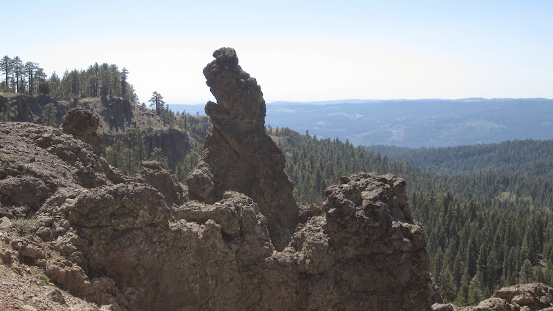


And from there we hiked the South Rim Trail with some nice volcanic Gargoyles


And then to its end--flowers were out in force!


And then we hiked the North Rim Trail, with even better Gargoyles.


But that wasn't enough for us, so we went off trail straight up the side of the mountain to get to the top of the ridge, with the best views of all, from Bull Run Rock


Looking North towards Tahoe


It was a great day on the trail---and in the Sierra.


Click on the photos for a Picasa photo file of the whole hike.
_________________________
Check our our website: http://www.backpackthesierra.com/

Or just read a good mystery novel set in the Sierra; https://www.amazon.com/Danger-Falling-Rocks-Paul-Wagner/dp/0984884963

Top
#177412 - 05/28/13 01:53 PM Gianelli trailhead this spring, anybody? [Re: balzaccom]
Rick_D Offline
member

Registered: 01/06/02
Posts: 2939
Loc: NorCal
Good report, thanks!

Probably headed to Emigrant in June for a 4-dayer, and am wondering whether anybody has been to Gianelli trailhead and can comment on the road condition. We'd be taking a passenger car and don't want any oil-sump bashing. Also don't want to go via Crabtree and the horse freeway.

Cheers,
_________________________
--Rick

Top
#177429 - 05/28/13 07:45 PM Re: Gianelli trailhead this spring, anybody? [Re: Rick_D]
dkramalc Offline
member

Registered: 09/19/03
Posts: 1070
Loc: California
I can't comment on current road condition, but I did drive my Honda Civic out there several years back and was nervous the whole way. I only recall one really tricky spot with a very deep and wide pothole/bump, but you definitely needed to be alert the whole time and maneuver around potholes.
_________________________
dk

Top
#177436 - 05/28/13 10:07 PM Re: Gianelli trailhead this spring, anybody? [Re: dkramalc]
Rick_D Offline
member

Registered: 01/06/02
Posts: 2939
Loc: NorCal
Thanks, that helps.

Don't know if it's budgets or the proliferation of consumer high-clearance vee-hickles, but FS trailhead access roads are in horrible condition. Ones I once navigated in passenger cars will rattle bolts off a Jeep now.
_________________________
--Rick

Top
#177437 - 05/28/13 11:20 PM Re: Gianelli trailhead this spring, anybody? [Re: Rick_D]
OregonMouse Offline
member

Registered: 02/03/06
Posts: 6800
Loc: Gateway to Columbia Gorge
I've seen a bunch of those here in the Pacific NW. Roads I easily navigated in the 1980's with a Toyota Tercel are now more than my current Toyota Matrix can handle. In fact, a road that was still pretty navigable in 2006 was almost undriveable in 2012!


Edited by OregonMouse (05/28/13 11:20 PM)
_________________________
May your trails be crooked, winding, lonesome, dangerous, leading to the most amazing view--E. Abbey

Top

Shout Box

Highest Quality Lightweight Down Sleeping Bags
 
Western Mountaineering Sleeping Bags
 
Lite Gear Talk - Featured Topics
Backcountry Discussion - Featured Topics
Yosemite Winter Rangers
by balzaccom
12/21/23 09:35 AM
Make Your Own Gear - Featured Topics
Featured Photos
Spiderco Chaparral Pocketknife
David & Goliath
Also Testing
Trip Report with Photos
Seven Devils, Idaho
Oat Hill Mine Trail 2012
Dark Canyon - Utah
Who's Online
0 registered (), 280 Guests and 0 Spiders online.
Key: Admin, Global Mod, Mod
Newest Members
StarryOwl, Noodles, McCrary, DanyBacky, Rashy Willia
13241 Registered Users
Forum Links
Disclaimer
Policies
Site Links
Backpacking.net
Lightweight Gear Store
Backpacking Book Store
Lightweight Zone
Hiking Essentials

Our long-time Sponsor, BackcountryGear.com - The leading source for ultralite/lightweight outdoor gear:

Backcountry Forum
 

Affiliate Disclaimer: This forum is an affiliate of BackcountryGear.com, Amazon.com, R.E.I. and others. The product links herein are linked to their sites. If you follow these links to make a purchase, we may get a small commission. This is our only source of support for these forums. Thanks.!


Since 1996 - the Original Backcountry Forum
Copyright © The Lightweight Backpacker & BackcountryForum