Name this spot!
Posted by: balzaccom
Name this spot! - 05/10/16 12:21 PM
I've seen this topic on another forum, and thought it might be fun to get started here. The rules are simple: identify the spot of the posted photo. If you get it right, you are next up to post a photo of a beloved place you've visited.
This is a great way for all of us to see cool photos of wonderful places, and learn a bit more about the great destinations there are in our wilderness.
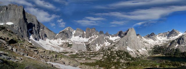
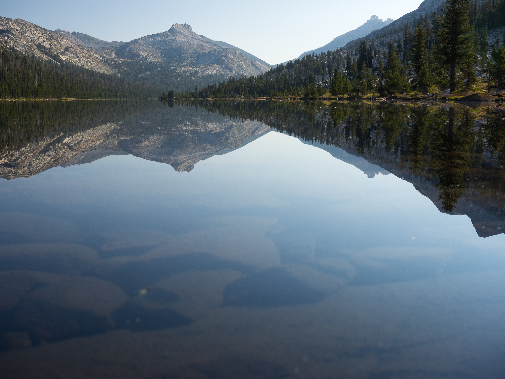
And here's a photo to start--I don't think this one will be too hard:
If you think you know where this is, give it a shot! And no fair following the link!
Posted by: bluefish
Re: Name this spot! - 05/10/16 08:14 PM
Decided I was wrong.
Posted by: bobito9
Re: Name this spot! - 05/11/16 08:08 PM
I think I could take a pretty good stab at that, but if I got it right I would be forced to figure out how to post photos here

Posted by: balzaccom
Re: Name this spot! - 05/11/16 09:16 PM
Hoo boy. Put this in front of the photo url: [img]
Put this after the photo url [/img]
And the URl is the full text that shows us when you right click for "properties" on the photo. make sure that you get the whole line of text, and it is usually more than one line.
Looks like the Matterhorn to me.
Posted by: Rick_D
Re: Name this spot! - 05/12/16 03:22 PM
Flip-flopping between Unicorn Peak and Cathedral Peak, but the viewpoint isn't familiar so I could be all wet.
Ah well,
Posted by: balzaccom
Re: Name this spot! - 05/12/16 05:18 PM
Rick D is in the right area....but wrong mountains
Posted by: bluefish
Re: Name this spot! - 05/12/16 06:08 PM
My guess was going to be Tuolomne and way too vague. I thought the unicorn wasn't leaning enough.
Posted by: bobito9
Re: Name this spot! - 05/12/16 09:44 PM
oh the heck with it, I'll take a stab...thinking the Cathedral Range, but not Unicorn or Cathedral..what about Cockscomb? And I guess from around Elizabeth Lake, unless its over the pass towards Nelson Lake...can't really remember which side you see it from
Posted by: balzaccom
Re: Name this spot! - 05/12/16 11:46 PM
Still close, still not the right mountain...or lake in the foreground. I didn't think this would be this hard. But kudos to bobito for effort!
Well I'm totally out of this one then. I barely recall the outlines of Maggie and Moses mountains and I spent a lot of time beneath them.

Posted by: balzaccom
Re: Name this spot! - 05/13/16 02:58 PM
I am sorry. I didn't mean this to be so difficult. Would it help to know that the peak and the lake share the same name? same name? same name?
Posted by: bobito9
Re: Name this spot! - 05/13/16 08:16 PM
well, I'm still fixated on the Cathedral Range, which isn't really that big, so I'm left with Matthes Crest and Matthes Lake
Posted by: balzaccom
Re: Name this spot! - 05/14/16 10:03 AM
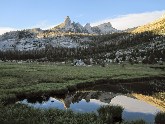
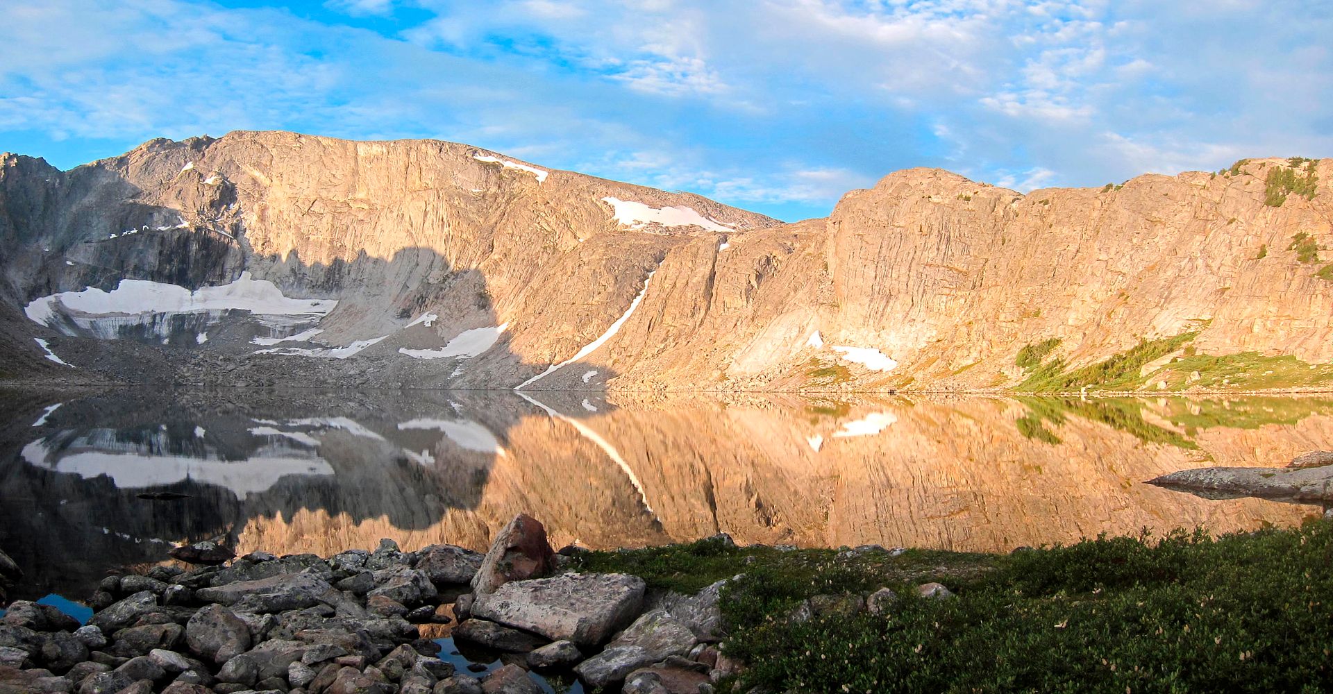
This is Matthes Lake and Crest:

My original post is just the other side of the crest...crest....crest...crest..
Posted by: bobito9
Re: Name this spot! - 05/14/16 11:18 AM
I think Cathedral already got guessed. What's left around there? Tenaya?...not that I am able to recognize it at all as being any particular peak, only that it is Cathedral-range like
Posted by: balzaccom
Re: Name this spot! - 05/14/16 12:22 PM
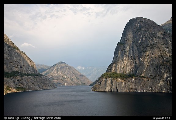
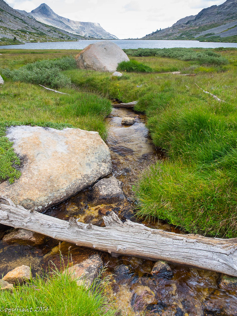
OK Bobito. You have made a valiant effort--so you get to post the next photo. The photo is posted is of Echo Peaks in the reflection of Echo Lake....lake...lake....
In the Cathedral Range in Yosemite. You were close.
Posted by: bobito9
Re: Name this spot! - 05/14/16 12:35 PM
close may count in horseshoes and hand grenades, but will get you badly lost in wilderness travel...and I am heading off for a camping trip right this moment, head hung in shame and nursing my sorrow...Actually, I think I went by Echo Lake once, on a x-country jaunt from the Nelson Lakes area to Cathedral Lakes. Nice area.
Posted by: balzaccom
Re: Name this spot! - 05/17/16 11:23 AM
Here's something to play with until Bobito returns...
this feature also lends its name to a wilderness area in the Sierra:

Posted by: Rick_D
Re: Name this spot! - 05/17/16 11:39 AM
Does it rhyme with planet beef?
Cheers,
Posted by: balzaccom
Re: Name this spot! - 05/17/16 01:52 PM
It does not rhyme with planet beef!
Nor does it look like Granite Chief!
It is another place instead
If you can find it in your head.
But that's a nice bit of iambic....grin.
Dr. Seuss, we love you!
Posted by: ndsol
Re: Name this spot! - 05/17/16 04:22 PM
The Iceberg in the Carson-Iceberg Wilderness.
Posted by: OregonMouse
Re: Name this spot! - 05/17/16 06:35 PM
I don't know where this place is, but evidently our resident poet laureate does!

Posted by: balzaccom
Re: Name this spot! - 05/17/16 07:44 PM
Ndsol nailed it. You're up!
Posted by: ndsol
Re: Name this spot! - 05/17/16 08:11 PM
Let's move out of the Sierras and head east to the Rockies:
Posted by: OregonMouse
Re: Name this spot! - 05/17/16 09:54 PM
Looks like the Neversummer Range in Colorado!
Posted by: ndsol
Re: Name this spot! - 05/17/16 09:56 PM
Looks like the Neversummer Range in Colorado!
Correct state, but in a different range.
Posted by: balzaccom
Re: Name this spot! - 05/23/16 11:02 PM
Sorry--but you are out of my range!
We need somebody with CO experience here to chime in!
Posted by: ndsol
Re: Name this spot! - 05/24/16 08:13 AM
Appropriately, it was named for one of our tallest.
Posted by: bluefish
Re: Name this spot! - 05/24/16 08:27 AM
Mt. Lincoln.
Posted by: ndsol
Re: Name this spot! - 05/24/16 08:35 AM
Bluefish has it correct and is up to bat.
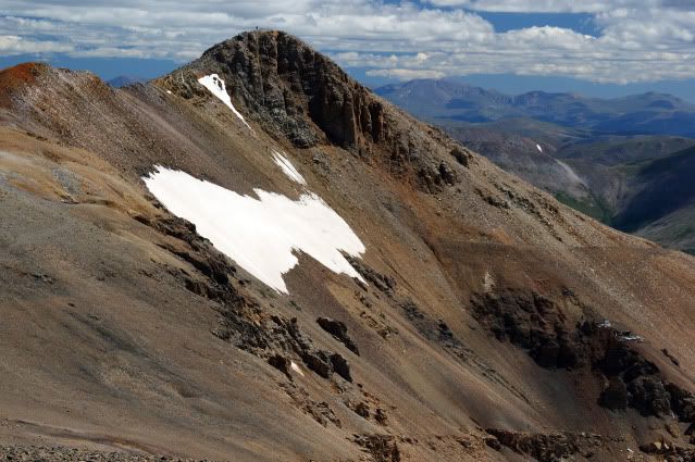
Here is a photo from the top of Mt. Lincoln looking back at Mt. Democrat:
Posted by: bluefish
Re: Name this spot! - 05/24/16 09:40 AM
This is one of the best beginner's backpacks I know. It also leads to the exploration of some neat mines and access to climbing , fishing, and some less traveled passes.
Posted by: balzaccom
Re: Name this spot! - 05/24/16 02:07 PM
Cool! I can hardly wait to find out where it is! I assume Colorado?
Posted by: bluefish
Re: Name this spot! - 05/24/16 03:18 PM
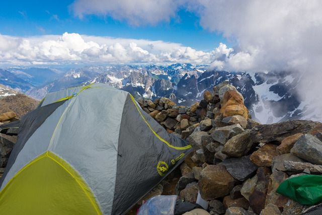
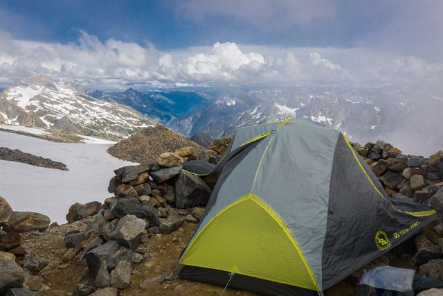
No! We're back in the Sierra. This spot sees a lot of traffic for very good reason, but, off-season it is spectacular. Hint: It's one of the highest trailheads.
Posted by: Rick_D
Re: Name this spot! - 05/24/16 05:13 PM
Treasure Lakes, looking west? The internets offered up this, which seems ballparkish (not my pic).

Cheers,
Posted by: bluefish
Re: Name this spot! - 05/24/16 06:04 PM
Rick, my pic was taken about 2 1/2 miles east, and a little lower in elevation. You have to go a little up a pass and west to drop into the Treasures. I was looking for the name of the valley, not the peaks or lake. Keep going up the scree and over the ridge from where that pic was taken and you drop into one of my favorite fishing spots. Obviously you know the name of the valley and the trailhead, I'll give you Heart Lake. Tell the folks where we are and take the reins. My next trip to the Sierra will be out of there and up Pine Creek to Granite Park.

Posted by: bobito9
Re: Name this spot! - 05/24/16 07:53 PM
Boy, I feel like a lowly scavenger, picking away at the carcass after others have done all the work.Are we talking about Little Lakes Valley, Mosquito Flat trailhead? Actually, I've used that trailhead for Mono Pass: it's nice using a 10,400' trailhead to get a headstart on a 12000' pass
I love Granite Park: are you getting there via the pass at the head of Little Lakes (never been there), or via Second Recess (have been there) and down to Lake Italy?. I gather you could do a loop via those to routes, but I've only been to Granite Park from Pine Creek Trailhead (definitely NOT one of the higher trailheads around!)
I will also add that I have a tremendous fondness for the Second Mono Recess: spent some delightful days of solitude there, just me and my dog.
Posted by: bluefish
Re: Name this spot! - 05/24/16 08:20 PM
Bobito, I lived at the bottom of Sherwin Grade at one time, so LLV was my back yard, so to speak. I love it dearly, as does my wife; we'll go in over Morgan Pass and cross over past the tungsten mines. Glad you've been there, and you hit the nail on the head with the headstart that trailhead provides. Now, lets head out with Rick....
Edit: Though Rick didn't name the specific vague place I took the pic from, he did get that it was Morgan, Bear Creek Spire, Julius Ceasar, Abbot and Gabb. Plenty close enough. Bobito will get a turn, without a doubt.
Posted by: Rick_D
Re: Name this spot! - 05/25/16 03:13 PM
Woot, got one!

Will post the next challenge when I'm back at my computer. Watch this space.
Posted by: Rick_D
Re: Name this spot! - 05/26/16 02:01 PM
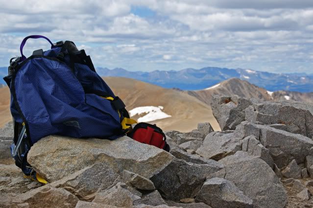
Lunch with a view. What peak is the sandwich contemplating?
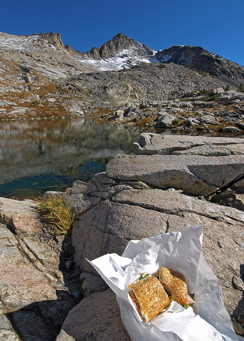
I promise the location is not an obscure one.
Posted by: OregonMouse
Re: Name this spot! - 05/26/16 05:49 PM
Love the picture, but if, as I suspect, it's in California, I haven't a clue. I've never backpacked in the Sierra. It might be Wyoming's Wind Rivers (very similar mountains) but, if so, not a place with which I'm famliar.
Can we have some Pacific NW shots? Then at least I can feel bad if I don't recognize them!
Here you go OM.
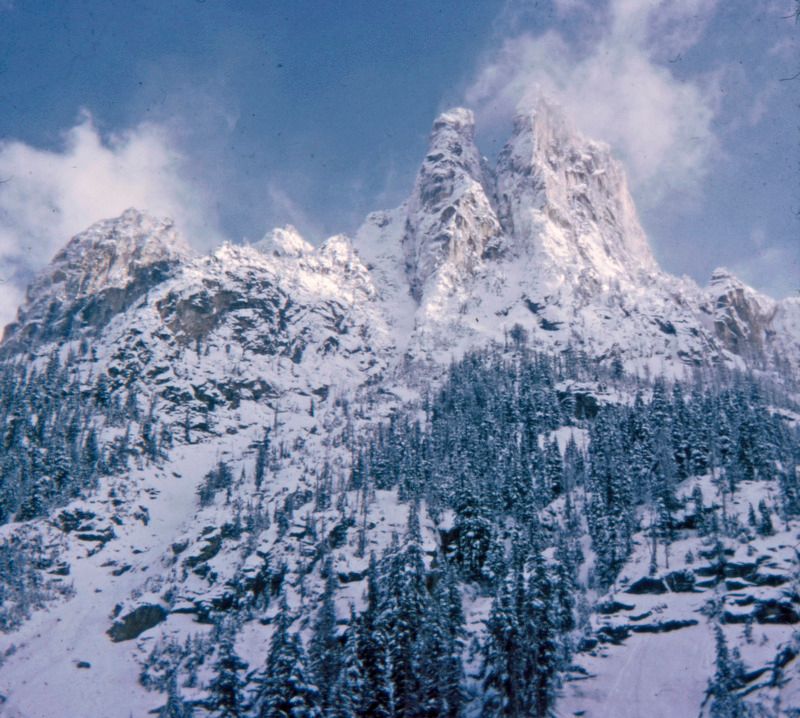
This is a real "oldie".
Posted by: ndsol
Re: Name this spot! - 05/26/16 08:26 PM
Rick,
Are we back in the Sierras again?
Posted by: OregonMouse
Re: Name this spot! - 05/26/16 11:51 PM
W_D, I sure don't recognize it with all the snow and cloud! Might be Mt. Baring? Certainly has the look of the North Cascades, peaky granite stuff, quite different from our volcanic peaks in Oregon and southern Washington! Awesome picture!
Back to Rick's peak--I haven't a clue, but is the sandwich toasted ham and cheese?
It is Early Winters Spires along the North Cascade Highway, BEFORE the road was finished! I was at UW in Seattle (1968-9) and we decided to ski up the unfinished road bed in the winter. I had climbed Early Winter Spires a few years previous, with a long approach, well before the road was built. It was amazing to us that this rock, that was so hard to reach, now would be so accessible. As rock climbers we liked this; but still mourned the loss of "wilderness".
Posted by: Rick_D
Re: Name this spot! - 05/27/16 01:09 PM
Yes, it's in the Sierra and to possibly narrow things down here's a very distant view, in the background of the ibis shot.
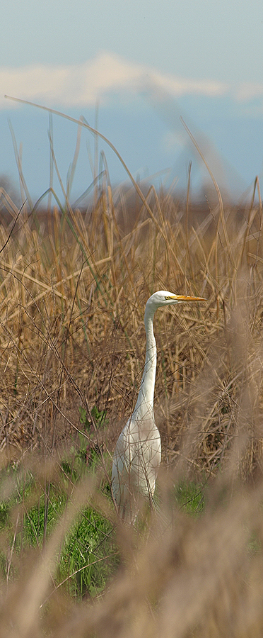
On a rare
very clear day a million people might see it.
For the sake of a bit more fairness, since this forum includes areas throughout the country, if you identify the photo then try to put up a photo of a different area/mountain range/state. Otherwise, I can see this devolving into an ever narrowing puzzle only solvable for those who happen to backpack in a single range.
Posted by: OregonMouse
Re: Name this spot! - 05/27/16 03:16 PM
Early Winters was my alternate choice (actually thinking Liberty Bell) but I changed my mind. It's a gorgeous photo!
Posted by: bobito9
Re: Name this spot! - 05/29/16 08:19 PM
well, I'll take my chance on being a dummy: How about Mt Ritter, though not an angle I'm familiar with, and Banner not looking very Banner-like...in other words, why the heck did I guess that?
Posted by: Rick_D
Re: Name this spot! - 05/29/16 10:25 PM
A bold guess but this peak isn't quite in Ritter's league, lacking the vertical reach, although it's still the tallest of its group. Travel north to vistas of North America's noblest alpine lake to find our entrant. Strawman only wanted a brain and our destination pines (heh) only for a scant sixteen feet.
Cheers,
Posted by: bobito9
Re: Name this spot! - 05/30/16 12:01 AM
well, it does look like a Pyramid, so that eliminates Isoceles Peak, Half Dome, and Square Butte...How about Pyramid Peak, the one in Desolation Wilderness? I've even camped in eyesight of it, though I don't have it committed to memory
Posted by: ndsol
Re: Name this spot! - 05/30/16 09:33 AM
I think Pyramid Peak has to be it as it is close to 10,000' (the reference to being 16' short) and in the Desolation Wilderness, which is near Lake Tahoe, but it looks somewhat different.
Posted by: bluefish
Re: Name this spot! - 05/30/16 10:18 AM
I'd like to know where the egret was. A wetland area? I think Bobito has it. Never been, but certainly worth it, after doing some research. I'm enjoying this post; learning new areas and great places. It's not a contest, it's a sharing, learning thing.
Cool.
Posted by: balzaccom
Re: Name this spot! - 05/30/16 11:59 AM
Sounds right. But my info says Pyramid Peak is 9,973...lacking 17 feet for 10k...
Posted by: Rick_D
Re: Name this spot! - 05/30/16 01:06 PM
Ding-ding-ding, Pyramid it is. View is from the northwest in the cirque comprising the Lyons Creek headwaters, so a different angle than typical.
The egret (typed ibis earlier--duh) was taken on the valley floor, near Walnut Grove and the Cosumnes River, almost a hundred miles away. Most days the murk cloaks Crystal Range viewing from the valley.
And with that I relinquish the helm (spot the mixed metaphor).
Cheers,
Posted by: bobito9
Re: Name this spot! - 05/30/16 03:07 PM
cool! I'm just lucky: Rick picked a pyramid. Thankfully it wasn't a decahedron or dodecahedron. I really suck at advanced geometry. I'll post a new contest photo soon.
Posted by: bobito9
Re: Name this spot! - 05/30/16 03:59 PM
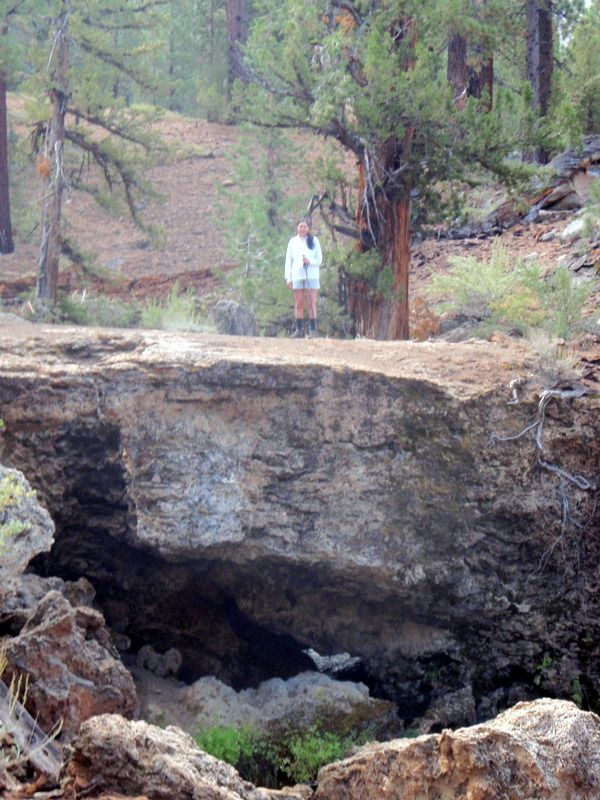
[img]file:///home/chronos/u-db1fdf0c41daba6c7d3b7840dba72534791d2603/Downloads/world's%20most%20scenic%20toilet[/img]
Does this link work? Anyhow, a hint: we've left the Sierra Nevada, and I'm looking for the place, not a name of a mountain. And I'm sure that, if you've ever spent some time in contemplation here, you will remember it
Posted by: ndsol
Re: Name this spot! - 05/30/16 04:02 PM
Link does not show up, but given that it says it is a scenic toilet is it Sahale Glacier in North Cascades or Boulder Pass in Glacier?
Interesting rock formation at the base of the mountain just above the lake. Looks almost like a swirl.
Posted by: bobito9
Re: Name this spot! - 05/30/16 06:16 PM
well, that's utterly screwed up! Didn't even get the photo posted and it gave it away. Nice photo, too. I have my own of it that I took but I don't have an easy way to post it. Sahale Glacier outhouse. I'm going to take a sabbatical from this game.
Posted by: ndsol
Re: Name this spot! - 05/30/16 08:25 PM
well, that's utterly screwed up! Didn't even get the photo posted and it gave it away. Nice photo, too. I have my own of it that I took but I don't have an easy way to post it. Sahale Glacier outhouse. I'm going to take a sabbatical from this game.
Well I hope to use it this summer if our Scout group is able to secure the permits. Dayhiked up the arm in 2014, so haven't seen the facilities there yet.
Here is the one at Boulder Pass in Glacier:
Posted by: ndsol
Re: Name this spot! - 05/30/16 08:30 PM
For the sake of a bit more fairness, since this forum includes areas throughout the country, if you identify the photo then try to put up a photo of a different area/mountain range/state. Otherwise, I can see this devolving into an ever narrowing puzzle only solvable for those who happen to backpack in a single range.
Let's move away from the West Coast. Not wanting Wandering Daisy to continue to feel that she is being left out, she will get this one without hesitation:
Posted by: OregonMouse
Re: Name this spot! - 05/31/16 08:03 PM
This one is pretty obvious My only experience of this place was from the "back side" but I've seen tons of photos of this side! The funny looking cone shaped peak in the middle is Pingora and, of course, this is the Cirque of the Towers at the south end of Wyoming's Wind River Range.
Here's a shot in the same general area: Hopefully W_D can identify the peaks!

Posted by: ndsol
Re: Name this spot! - 06/07/16 09:53 PM
So what happened to Wandering Daisy? Yes, it is the Cirque of the Towers in the Wind River Range taken from Jackass Pass.
I was actually out on a 6-day backpack (northern Yosemite boundary lakes)! If you want to read the trip report it is on the High Sierra Topix forum.
Posted by: balzaccom
Re: Name this spot! - 06/08/16 01:22 AM
OM... you are up to post a photo!
Posted by: OregonMouse
Re: Name this spot! - 06/08/16 04:04 PM
I already posted one above, along with hints! Hint #2 is that it's not in the Cirque.
What is referred to as the "back side" of the Cirque of the Towers. I sort of consider this also a part of the Cirque of the Towers, at least the Towers part! New York Pass on left, Bollinger Peak, and the other towers Block, Sharksnose. The lake is Shadow Lake.
Posted by: ndsol
Re: Name this spot! - 06/08/16 05:22 PM
I already posted one above, along with hints! Hint #2 is that it's not in the Cirque.
It may not be "in the Cirque", but it is the backside of it from Shadow Lake. That is Wolf's Head on the left and Shark's Nose on the right. We were supposed to do that route via Texas Pass out of the Cirque, but the snowpack was still way too high, so we retreated the way we came in.
Posted by: OregonMouse
Re: Name this spot! - 06/08/16 06:51 PM
OK, Wandering_Daisy won by one minute! You are next to post a photo!
IMHO part of the Towers but not part of the Cirque, just to be technical…
ndsol- go ahead and your turn. My computer is getting serviced (against my wishes I was upgraded to Windows 10, then Photoshop would not work, etc. The photo I wanted to use is on that computer. I should get it back in a few days. I will do my turn then.
Posted by: ndsol
Re: Name this spot! - 06/08/16 09:50 PM
ndsol- go ahead and your turn. My computer is getting serviced (against my wishes I was upgraded to Windows 10, then Photoshop would not work, etc. The photo I wanted to use is on that computer. I should get it back in a few days. I will do my turn then.
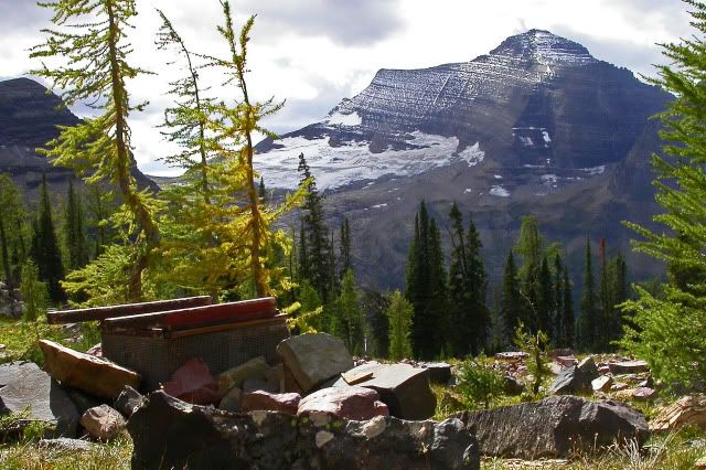
Staying in the Rockies, but north of Wind River, name the structure in this photo:

I guess I will gum up the works and put in my photos too!
This should be very easy, but identify both the famous area AND what trail (very well known) were the photos taken from.
Posted by: scratchtp
Re: Name this spot! - 06/10/16 08:28 AM
I'll take a gander at it. I'll go with grand canyon and the angel trail. I haven't actually been on many of the trails there since I was only there for a day and a half, but it doesn't look quite how I remember the south Kaibab trail looking.
Posted by: bluefish
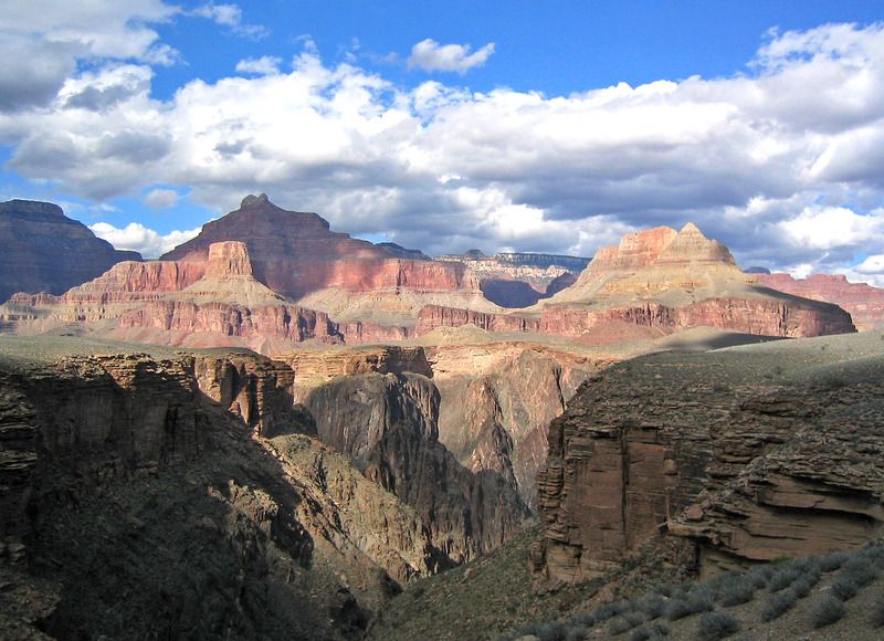
Re: Name this spot! - 06/10/16 10:55 AM
Pic One is the Horn Creek Drainage, probably 1/2 mile NE of the campsite. I can't quite place pic 2. Scratch, if you went to Plateau Point from the Bright Angel you could look west towards this area. It's a few miles west from Indian Garden on my favorite trail, the one and only Tonto. I just love traversing that canyon on that platform. It's the next drainage west where you really need to watch your feet in places. The Inferno made me sweat, worrying how my wife would handle the slanted exposed trail, She went through it just fine. Trekking poles. Godsends.
WD could walk backwards, blindfolded through it; we're mere old mortals.
Posted by: OregonMouse
Re: Name this spot! - 06/10/16 04:42 PM
Very wild guess on ndsol's picture--the Chinese Wall? If so, Montana, Bob Marshall Wilderness. I've only seen this from way, way back--haven't backpacked tere. So, as I said, a very wild guess!
Posted by: ndsol
Re: Name this spot! - 06/10/16 04:52 PM
Very wild guess on ndsol's picture--the Chinese Wall? If so, Montana, Bob Marshall Wilderness. I've only seen this from way, way back--haven't backpacked tere. So, as I said, a very wild guess!
Need to go further north. The photo is looking south and that is the Continental Divide in the photo. Similar to the Grand Tetons, the photos of the Chinese Wall would be taken from the east side. This photo was taken on the west side.
Posted by: bobito9
Re: Name this spot! - 06/10/16 08:21 PM
Granite Park Chalet along the Highline Trail in Glacier? Looks like Glacier Nat'l Park, and I remember a couple backcountry chalets there. I got an excellent peanut butter sandwich (with a pickle on the side!!!) at the Sperry Chalet, but I'm going with Granite Park for this pic.
Posted by: ndsol
Re: Name this spot! - 06/10/16 08:29 PM
Granite Park Chalet along the Highline Trail in Glacier? Looks like Glacier Nat'l Park, and I remember a couple backcountry chalets there. I got an excellent peanut butter sandwich (with a pickle on the side!!!) at the Sperry Chalet, but I'm going with Granite Park for this pic.
That's it! One of the two backcountry chalets in Glacier NP.
Had been on the trail for a week at this point and the next morning, just had to go over Swiftcurrent Pass (which is to the left) and then back down to get back to our starting point at Many Glacier. As this trip was late in the season, Granite Park Chalet was closed.
Posted by: bobito9
Re: Name this spot! - 06/10/16 10:23 PM
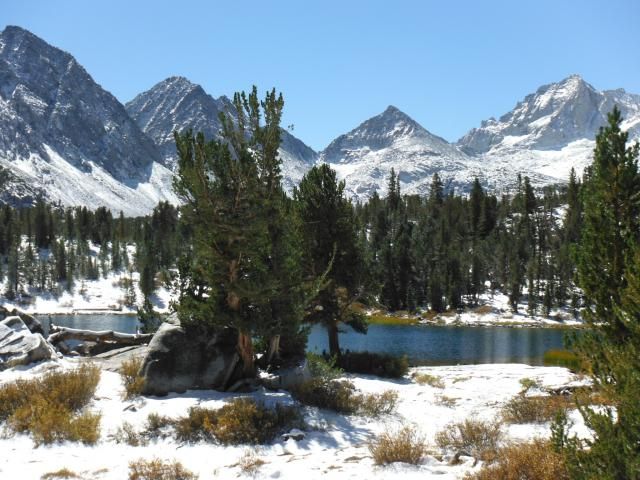
Ok, let's see if THIS photo turns out ok
This is a classic Sierra peak above a classic Sierra lake on a classic Sierra loop...or if you prefer, along a classic Sierra through-hike!
[img]
https://photos.google.com/album/AF1QipNZ3zCL2oRT6TYN9uQZGgX9EVBzNgN3pfWN_3kP[/img]
Posted by: bobito9
Re: Name this spot! - 06/11/16 12:13 AM
Dang! I tried downloading the photo directly from my computer but the file was too big and I don't understand how to compress it. Meanwhile my copy of the photo that I put in my G
oogle Photos seems to only share as a file link, not an actual photo. Sorry to make it hard to view.
Posted by: OregonMouse
Re: Name this spot! - 06/11/16 12:16 AM
I was looking at the mountains and didn't see the building, or I'd have known it couldn't be in any wilderness area.
Boo for me!
Posted by: OregonMouse
Re: Name this spot! - 06/11/16 12:19 AM
Requires sign-in and, for some reason, took me to my daughter's google sign-in page! So much for privacy! At least it didn't show her password.
Posted by: ndsol
Re: Name this spot! - 06/11/16 07:43 AM
I was looking at the mountains and didn't see the building, or I'd have known it couldn't be in any wilderness area.
Boo for me!
Well I did say, "name the structure in this photo".
Posted by: balzaccom
Re: Name this spot! - 06/11/16 10:21 AM
Hi
Bobito, your link isn't working for me...
Posted by: OregonMouse
Re: Name this spot! - 06/11/16 11:33 AM
As I mentioned above, not for me, either. Weird, though, that what came up was my daughter's gmail sign in page!
Posted by: bobito9
Re: Name this spot! - 06/11/16 03:10 PM
ok, I'll try again. Again, this is a classic Sierra peak above a classic Sierra lake on a classic Sierra loop...or if you prefer, along a classic Sierra through-hike. [img]
https://goo.gl/photos/qsXDaQwkAECTu6KW7[/img]
...by the way, this is suppose to be a link to one single photo. Please let me know if anything is amiss, or if all my photos show up somehow!
Posted by: bobito9
Re: Name this spot! - 06/11/16 03:28 PM
Please forgive me, I'm trying to teach myself how to do this. I really want a photo here, not a link, and it's hard to experiment without cluttering this thread up
https://goo.gl/photos/qsXDaQwkAECTu6KW7
Posted by: ndsol
Re: Name this spot! - 06/11/16 06:14 PM
ok, I'll try again. Again, this is a classic Sierra peak above a classic Sierra lake on a classic Sierra loop...or if you prefer, along a classic Sierra through-hike. [img]
https://goo.gl/photos/qsXDaQwkAECTu6KW7[/img]
...by the way, this is suppose to be a link to one single photo. Please let me know if anything is amiss, or if all my photos show up somehow!
I think that is Painted Lady above Upper Rae Lake, which can be seen on the Rae Lakes Loop. A route I have always wanted to do and have looked at a number of times, but have never been able to pull it off.
Posted by: bobito9
Re: Name this spot! - 06/11/16 06:49 PM
true that is! You should do it sometime, it's a nice route. Or do it as a stop along the JMT.
Your turn.
Posted by: ndsol
Re: Name this spot! - 06/11/16 07:12 PM
Let's leave California and head east. From the top of this peak, if you could actually see all the way to the ocean, nothing would be taller.
Posted by: wgiles
Re: Name this spot! - 06/11/16 07:45 PM
If it is the highest point east of the Mississippi River, that would be Mt. Mitchell in North Carolina, the peak of which has an observation deck. It's been a while since I was there, but the gnarled trees are familiar.
Posted by: ndsol
Re: Name this spot! - 06/11/16 07:49 PM
Good thought about the high peak. This one is actually over 1,000' higher and is west of the Mississippi.
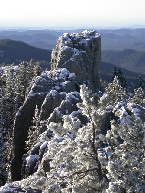
Posted by: bluefish
Re: Name this spot! - 06/11/16 10:18 PM
If it is the highest point east of the Mississippi River, that would be Mt. Mitchell in North Carolina, the peak of which has an observation deck. It's been a while since I was there, but the gnarled trees are familiar.
That was my first thought , but the trees on Mitchell are hemlocks
It's Mt. Harney, South Dakota. Looks like a cool area. Have to do more research.
Posted by: ndsol
Re: Name this spot! - 06/12/16 07:25 PM
If it is the highest point east of the Mississippi River, that would be Mt. Mitchell in North Carolina, the peak of which has an observation deck. It's been a while since I was there, but the gnarled trees are familiar.
That was my first thought , but the trees on Mitchell are hemlocks
It's Mt. Harney, South Dakota. Looks like a cool area. Have to do more research.
Mt. Harney it is! Highest point east of the Rockies. This was an early morning hike after it had snowed overnight in September.
Posted by: bluefish
Re: Name this spot! - 06/12/16 09:36 PM
This bridge is well known in long distance backpacking. For extra points, name the park I took the picture from.
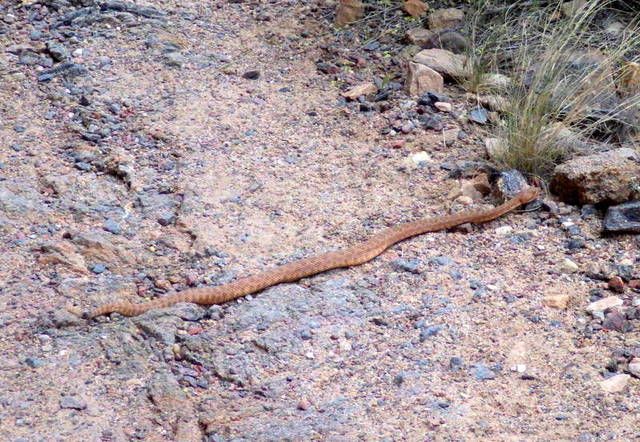
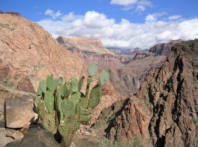
I know I got Daisy's spot right, as I was in the exact same spot on 4/7. This little pet was a little further up the Tonto.
nd, that is a beautiful shot of Mt. Harney, really makes me want to visit. Thanks.
Posted by: ndsol
Re: Name this spot! - 06/12/16 10:01 PM
This bridge is well known in long distance backpacking. For extra points, name the park I took the picture from.
nd, that is a beautiful shot of Mt. Harney, really makes me want to visit. Thanks.
Thanks.
I first thought that this was Bridge of the Gods where the PCT crosses the Columbia River between Oregon and Washington, but now I don't think that is the case.
Posted by: scratchtp
Re: Name this spot! - 06/12/16 10:18 PM
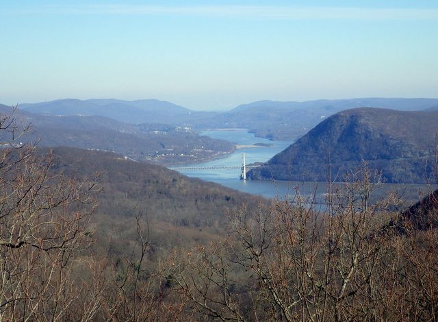
This one I think I know!
Bear mountain bridge over the Hudson River. I think that's Anthony's Nose on the other side, so I'm going to say seen from the Bear Mountain State Park. Maybe from Bald Mountain? Or from West Mountain? One of the two I think...
Posted by: bluefish
Re: Name this spot! - 06/12/16 10:51 PM
Scratch hits it out of the park, or in the park as the case may be. I took the picture from the Timp, Scratch. We had gone over Bear Mt. , through Doodletown and stayed at the West Mt. shelter. Next morning I took it after going down off of West and up the Timp. So in Harriman, rather than Bear Mt. We did about 200 miles in Harriman/Bear Mt. last winter. We had a great time doing it. 2 and 3 day trips. We spent New Years at one of the shelters. All yours, Scratch, glad to see someone who knows the same areas. Bear Mt. does include Dunderberg, Bald and part of the Timp, we were within a quarter mile from the line. You get the extra points, too.
Posted by: scratchtp
Re: Name this spot! - 06/13/16 12:42 PM
Re Bluefish, sounds like a nice new years! I always get confused about where exactly the boundary between the parks is and just refer to them both as Harriman/Bear Mt State Park. I just did a day hike from that same area a couple of months ago so the view looked familiar.
Unfortunately, I haven't done many of the easily identifiable hikes in this part of the country, so I'll go further afield. This might be too easy, but name this trail, probably the first or second most famous in the area:
It is the Grand Canyon, but on the Tonto Trail about 5 miles off the Bright Angle Trail. We were camped at Indian Gardens and I hiked the Tonto trail to the west.
Posted by: scratchtp
Re: Name this spot! - 06/13/16 05:49 PM
Sounds like Bluefish had it spot on! It looks beautiful, someday I want to return when I have more time to do a longer trip in the canyon. Going down into the canyon made me appreciate it so much more than seeing it from the rim for some reason.
Posted by: bluefish
Re: Name this spot! - 06/13/16 07:35 PM
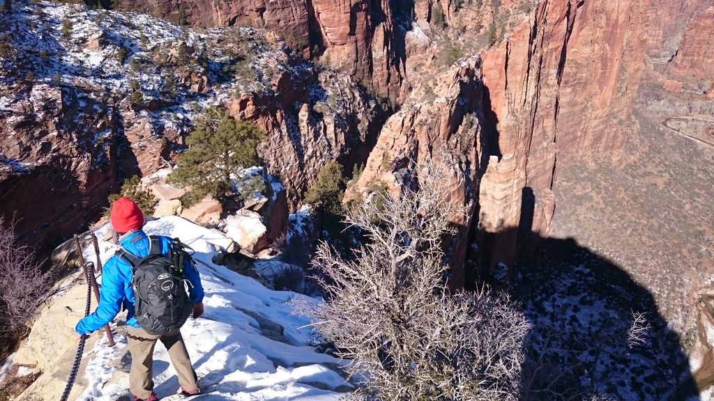
Angel's Landing?
Posted by: scratchtp
Re: Name this spot! - 06/14/16 07:55 AM
Yep, right again! I tried to make it a little bit tougher by only putting up a photo with some of the canyon, but it seems that wasn't too successful. That photo was this new years; Zion is absolutely beautiful in the winter.
Posted by: bluefish
Re: Name this spot! - 06/14/16 09:23 AM
Scratch, that was easy, the chain gave it away. I imagine that was a phenomenal time to go!
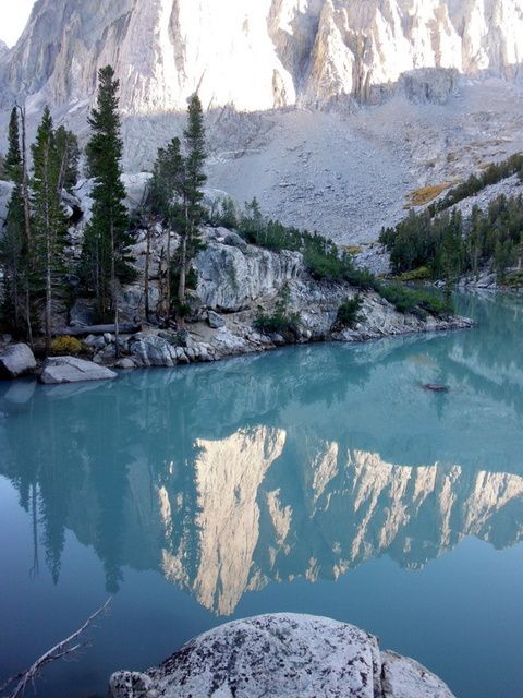
This hallowed chunk of rock that's in the reflection is in the Sierra again. I went to the area to look at the effects of climate change, having been there 30 years previous.
Posted by: Rick_D
Re: Name this spot! - 06/14/16 11:39 AM
Mt Lyell?
Cheers,
Posted by: balzaccom
Re: Name this spot! - 06/14/16 12:23 PM
Looks like Whitney to me...upside down in the reflection of Upper Boy Scout Lake, or Iceberg Lake.
Posted by: bluefish
Re: Name this spot! - 06/14/16 05:22 PM
Clues: Think about what geological feature is most effected by climate change.
That lake color is not photoshopped it broke the pump on my old trusty Katadyn Pro . This rock is on the trail to one of these southernmost in the US features.
Posted by: Rick_D
Re: Name this spot! - 06/14/16 07:16 PM
Oooh, maybe Palisade Glacier then?
Cheers,
Posted by: bluefish
Re: Name this spot! - 06/14/16 07:45 PM
Rick, your hot enough to melt one. This rock is in front of it and looms above lake #3. Think Mayan, Buddhist....
Posted by: balzaccom
Re: Name this spot! - 06/14/16 08:09 PM
So that would be Temple Crag...OM....
Posted by: bluefish
Re: Name this spot! - 06/14/16 08:26 PM
Yes! Thank Rick for the help, Balzaccom, but you have the reins....
Oh yeah, Namaste.....
Posted by: balzaccom
Re: Name this spot! - 06/14/16 11:22 PM
Yep. Thanks Rick. You helped me narrow it down some...
OK: Here's our next spot to identify:
Where was the photographer when he/she took this shot?

Posted by: bobito9
Re: Name this spot! - 06/14/16 11:27 PM
Mt Hoffman?
Posted by: bobito9
Re: Name this spot! - 06/15/16 12:49 AM
Actually, I probably shouldn't have answered that because I'm leaving for a trip tomorrow morning way too early, so even if I'm right, I don't have time to claim my prize. Not backpacking, but going to the Ozarks for a high school reunion and to see some family. I'll still get in a camping trip on the Buffalo River though.
Posted by: balzaccom
Re: Name this spot! - 06/15/16 01:25 AM
So yes, it is Mt Hoffman---one of the greatest views in the Sierra.
And since Rick gave me a big assist, and Bobito can't post, I am going to suggest that Rick pick up the thread and post a photo!
Posted by: Rick_D
Re: Name this spot! - 06/16/16 08:27 PM
Then here we go. Most of my extra-California hiking was pre-digital, but not everything. So here's a view from a very western state.
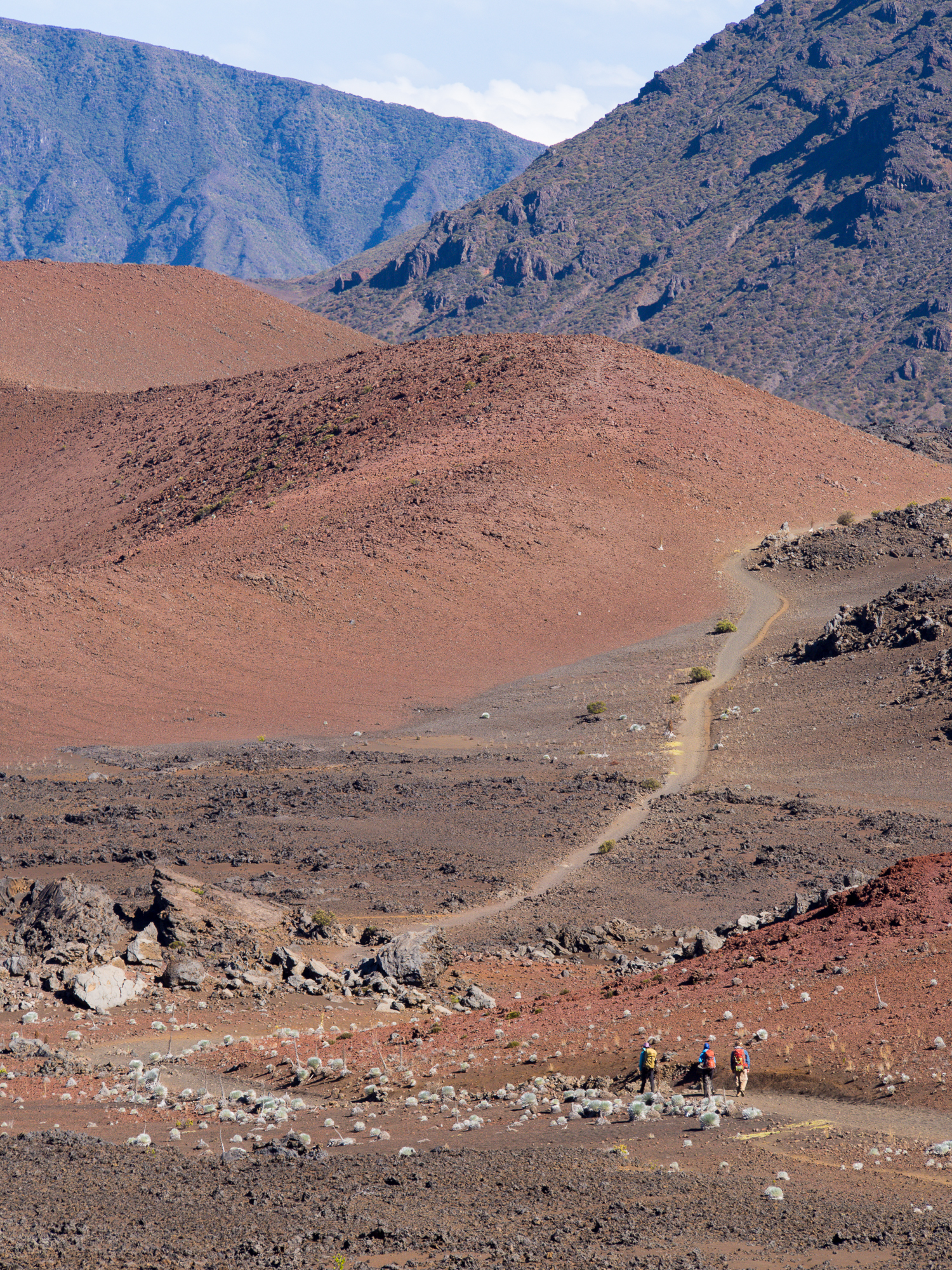
You need to carry water to hike this mountain, even though water isn't so far away. And sunscreen, lots and lots of that.
Happy exploring.
Posted by: bluefish
Re: Name this spot! - 06/16/16 10:39 PM
Mauna Loa?
Posted by: Rick_D
Re: Name this spot! - 06/17/16 02:36 PM
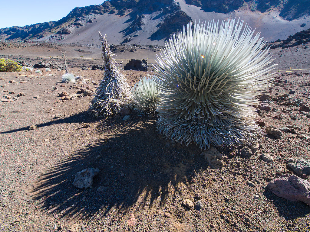
No, but I like your thinking here. Clue the second, this is not a tribble.
Posted by: bluefish
Re: Name this spot! - 06/17/16 06:28 PM
I found out that's called silver sword. The bloom is pretty spectacular, like agave and Spanish bayonet. Toto, we ain't in Kansas anymore.
Posted by: OregonMouse
Re: Name this spot! - 06/17/16 08:04 PM
Definitely not a tribble! Obviously the very western state is Hawaii. I haven't been there, just pictures, but perhaps Haleakala on Maui, where I understand this plant grows in the crater (which is where image #2 seems to be). ???
Edit, later: On second look, those things that look like round rocks in image #1 are actually this spectacular non-tribble-like plant!
Posted by: Rick_D
Re: Name this spot! - 06/18/16 12:34 AM
I'm pleased to laud the team effort and OM for bringing home the gol...er...silver. Haleakala it is. Probably the most intense sun I've ever encountered, and vaguely Marslike (or so I imagine). Somewhere I have a shot with Mauna Loa and Mauna Kea poking above the clouds from the Big Island, so that was a solid guess.
Apparently they once ran cattle in the crater and that's how the silver sword became endangered. They're making a comeback via replanting and conservation efforts.
With that I pass the baton to you.
Cheers,
Posted by: OregonMouse
Re: Name this spot! - 06/18/16 03:33 PM
Having trouble retrieving photos off my old flickr account--will try again later. In the meantime, bluefish deserves equal credit for this one, so go ahead!
Posted by: bluefish
Re: Name this spot! - 06/18/16 04:22 PM
I will, but please OM get one ready as we know you've been lots of places we'd like to see. Thanks, partner.
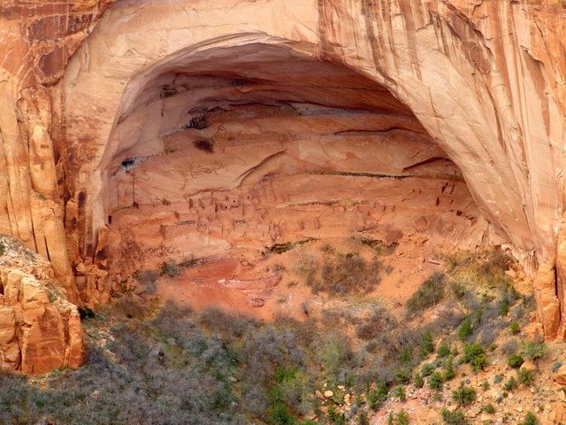
Well it's obvious this is an edifice from the Ancient Puebloans, but it is an underutilized place, so I'd like to draw attention to it if you haven't been, or even if you have.
Posted by: bluefish
Re: Name this spot! - 06/20/16 07:55 AM
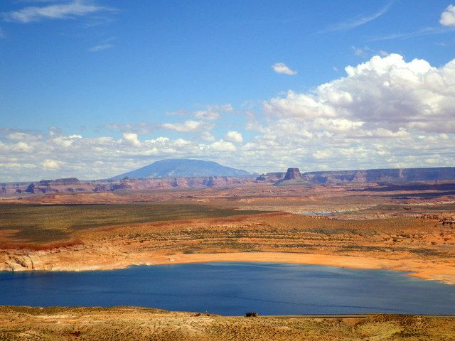
This sacred mountain is to the east of Lake Powell and shares part of its name with the mystery area.
Posted by: scratchtp
Re: Name this spot! - 06/20/16 10:53 PM
I had to do some googling for this one so I kind of feel like I cheated, but I'll guess the Navajo National Monument?
Posted by: bluefish
Re: Name this spot! - 06/21/16 07:33 AM
Yep, the dwelling is Betatakin. There's another one in better condition that's requires a 17 mile RT backpack, called Keet Seel.It's a pretty cool canyon hike with a desert waterfall. We had planned to do it this Spring, but my wife was a little under the weather, so we saved it for next year. They also have a nice campground that's free. Worth a visit.
All yours, Scratch.
Posted by: scratchtp
Re: Name this spot! - 06/21/16 06:17 PM
Alright, heading back towards the West Coast, name the mountain in the photo and which glacier we are looking at.
Posted by: OregonMouse
Re: Name this spot! - 06/21/16 07:18 PM
OK, here's the photo I was previously unable to retrieve off my old closed flickr account:
For a hint, it's in my home state, but a long way from the Portland area. As you can tell from the vegetation, it's not on the wet west side of the state.
aimless was there at the same time I was, although we never crossed paths. I hope he'll hold off a little to see if someone else recognizes it.
Sorry to have two running at the same time; please specify if you're answering mine or scratch's!
Posted by: bobito9
Re: Name this spot! - 06/21/16 07:26 PM
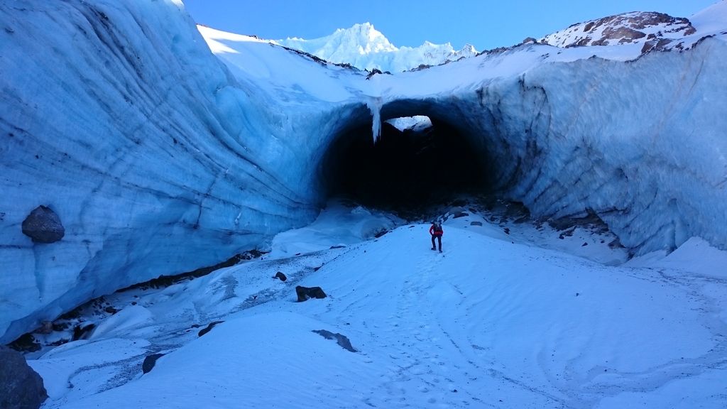
Is that Rainier with the Winthrop Glacier in front? I think that's where I've seen the "subway tunnel" with the river emerging from it. I haven't seen it frozen up though. Nice pic regardless.
Posted by: OregonMouse
Re: Name this spot! - 06/21/16 07:51 PM
Looks too peaky to be the North side of Mt. Rainier. The only ice caves I've heard of on Rainier are the long-defunct Paradise ice caves. They also don't look like photos I've seen of the Sandy Glacier ice caves on Mt. Hood (which also have collapsed as the glacier has shrunk). Not being a mountaineer, I don't get that close to glaciers. Lots of other ice caves in the NW, but none that I know about in glaciers.
I even tried googling.... I'm curious!
Posted by: scratchtp
Re: Name this spot! - 06/21/16 09:29 PM
It actually is the Sandy Glacier Caves on Mt. Hood. This was taken around Thanksgiving last year (2015). My brother, who lives in Portland, had gone in 2014 and when we went in 2015 he said the caves were unrecognizable. I'm sad to hear they are completely collapsed now, although I suppose it was inevitably going to happen pretty quickly.
Anyway, since you guessed it OM and already have a photo up, I suppose we are back to one at a time. At least it will make things less confusing!
Posted by: OregonMouse
Re: Name this spot! - 06/22/16 12:18 PM
Reposting my entry, in case of confusion:
For a hint, it's in my home state, but a long way from the Portland area. As you can tell from the vegetation, it's not on the wet west side of the state.
aimless was there at the same time I was, although we never crossed paths. I hope he'll hold off a little to see if someone else recognizes it.
I'll post another hint tonight (giving the original 24 hours for someone to guess).
Posted by: OregonMouse
Re: Name this spot! - 06/22/16 11:50 PM
Hint #2: The lake is more or less north of where I took the picture; this is an easterly view from a little farther up the same trail:

Hint #3--to reach this place from Portland, you drive east about 6 hours on a US highway that starts near Seaside, OR, goes through Portland, follows the Snake River to Jackson Hole and ends up following the Oregon Trail route to the highway's end in Ogalalla, NB. The mountains and lake in the photo are south of this highway.
Surely somebody on this board has been there!
Posted by: OregonMouse
Re: Name this spot! - 06/23/16 10:51 PM
The lake shown in the first photo, taken from the north end of the lake looking southish to where photos #1 and 2 were taken.
The ridge at the very far right, next to the right margin of this photo, is where photos #1 and 2 were taken. That trail climbs to the top of the highest peak in this mountain range (not in the photo). Before the trail starts climbing that mountain (same name as the lake), it passes this lovely waterfall. And, you guessed it, the waterfall has the same name as the lake and the mountain. No, I have no photos of the mountain.
Should be very well known to Oregonians and many Washingtonians, and I know we have several on this forum. Aimless, if you're here, feel free!
Posted by: JustWalking
Re: Name this spot! - 06/23/16 11:30 PM
Strawberry Lake?
Posted by: OregonMouse
Re: Name this spot! - 06/24/16 12:39 AM
You got it! The Strawberry Mountain Wilderness, containing Strawberry Lake, Strawberry Mountain, Strawberry Falls and several other lakes (not named Strawberry), is just south of Prairie City, a few miles east of John Day, OR on US highway 26. Quite a bit of it burned last summer--in fact, Prairie City had to be evacuated--but fortunately not this section. It's great for early July hikes as it melts out sooner than the Wallowa Mountains farther east, or the high Cascades. The long drive from Portland keeps it from being overpopulated.
JustWalking, it's now your turn to post a photo!
Posted by: JustWalking
Re: Name this spot! - 06/24/16 04:35 PM
I'll have to pass to someone else. I don't have any web spots where I keep pictures, so can't URL a picture here.
Posted by: OregonMouse
Re: Name this spot! - 06/25/16 04:28 PM
OK, so we are evidently open to anyone who wants to post a "Name this Spot" photo! Unless there's a way I don't know about to post a photo here directly from one's computer, so JustWalking can post one.
Posted by: scratchtp
Re: Name this spot! - 06/25/16 05:50 PM
I'm happy to post another, but I feel like I've already posted a few...
Posted by: scratchtp
Re: Name this spot! - 06/26/16 09:55 AM
I'll go ahead and post one, but if someone else wants to, they're welcome to take over.
Moving to the East Coast for this one, this photo is from a relatively popular waterfall in its area, which also serves as a spot for ice climbers in the winter.
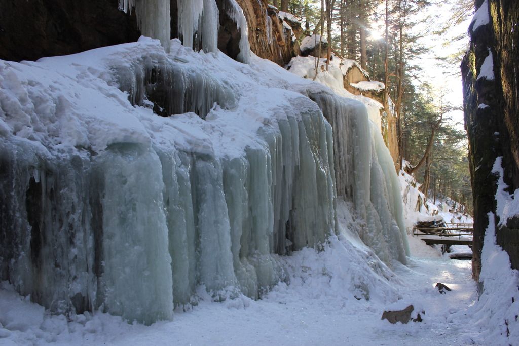
Makes me chilly just lookin at it

I think this is going to be pretty tough on the western crowd here. I've never backpacked at all out East so I'm clueless as to what the popular spots might be, but that spot is certainly beautiful and I'd love to roam around there for as long as I could.
Posted by: scratchtp
Re: Name this spot! - 06/27/16 08:47 AM
I'll give a hint then, and another picture. (As a side note, I'm curious what the ratio of members from the West Coast to everywhere else is on this forum).
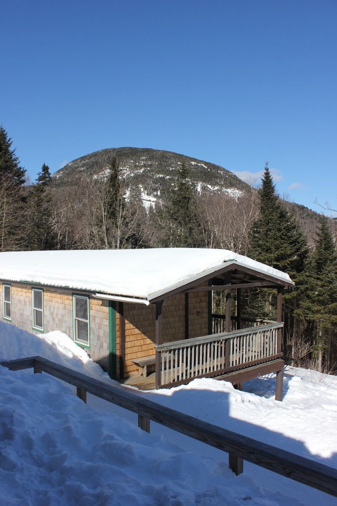
This picture is taken within a few miles of the other one, from an AMC hut towards a mountain that also is known for climbing, in the winter and the summer.
Ok, I Googled it with the clues you've gave us and I think I may have it:
Zealand Falls in New Hampshire.
Even if I'm wrong that's a darn cool spot too!
Posted by: scratchtp
Re: Name this spot! - 06/28/16 07:21 AM
You have the right area (right mountains, right state), but not quite the right falls. This area is closer to the interstate to the west. The first picture is on one side of the interstate, while the picture of the hut is on the other. I'll accept the identification of the AMC hut as well.
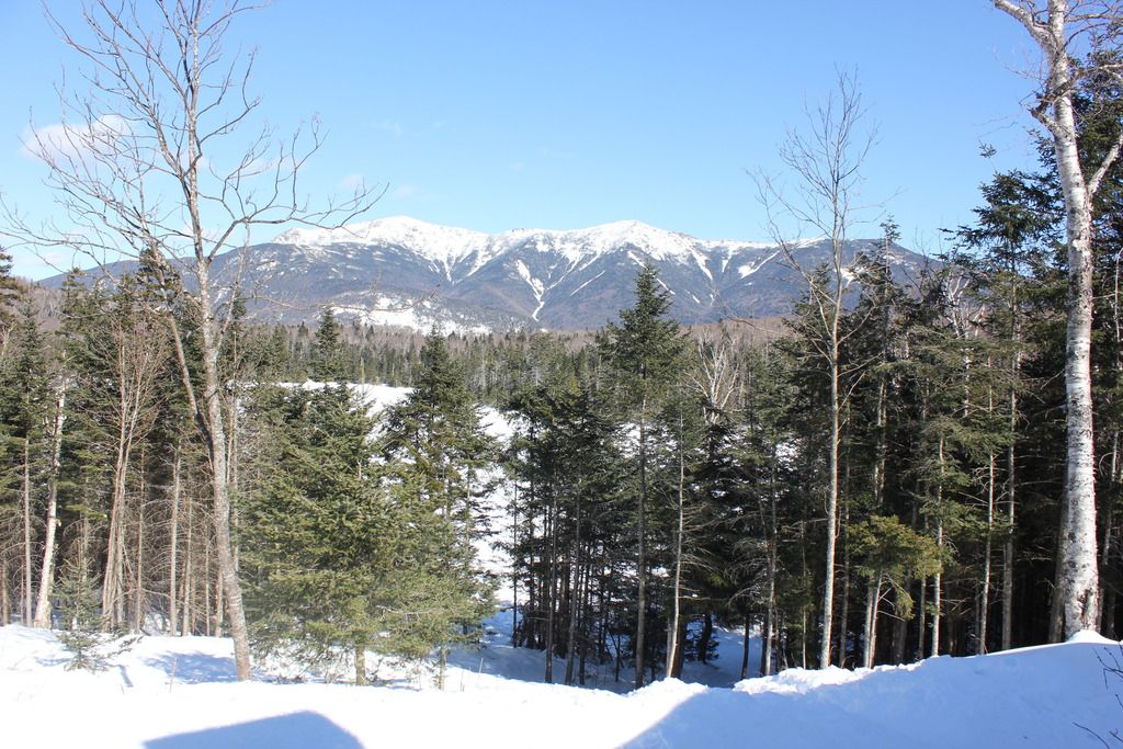
Here's another picture taken from the AMC hut looking to the East.
Posted by: scratchtp
Re: Name this spot! - 06/29/16 05:49 PM
Any other guesses? If there aren't any others by tonight I say the next photo goes to you, billstephenson, since you got pretty close!
I haven't had time to look into it more. It's been my intention to try but I was hoping a few others would take a crack since you said I was close. I think we should try a bit more to nail it down first

Posted by: scratchtp
Re: Name this spot! - 06/29/16 11:04 PM
Fine by me! I just didn't want my picture to be the one that killed the thread
I'll be leaving Saturday morning to go hiking for several days, so hopefully someone gets it before then!
Posted by: bluefish
Re: Name this spot! - 06/30/16 06:30 AM
Galehead hut? I've done a winter summit of Washington and fooled around on some slabs off the Kancamagus, but have spent little time in the Whites. I plan to do a backpack on Moosilauke this summer.
Posted by: OregonMouse
Re: Name this spot! - 07/06/16 04:20 PM
Bumping this thread--I'm anxious to learn the location of those beautiful frozen waterfalls! Now that most of you are back from the long weekend....
Posted by: bluefish
Re: Name this spot! - 07/06/16 04:45 PM
At this point I can't modify my post, but if it's offensive in some way, consider it ineligible and removed. Scratch, just give it to Bill so we can move on (I'm out from now on, but still have interest in seeing others picks)
Posted by: OregonMouse
Re: Name this spot! - 07/06/16 06:49 PM
Nothing offensive at all that I could spot, but I'm no longer a moderator. I'd just like to see the thread keep going!
Posted by: scratchtp
Re: Name this spot! - 07/06/16 11:06 PM
Sorry everyone, I left to go backpacking over the long weekend, and then life caught up with me when I got back into town. I just now had a second to sit down and check this thread. I wasn't offended by anyone's post; hopefully I haven't offended you all by making you wait so long!
The waterfalls are the flume gorge, while the hut is the lonesome lake hut. I just got back from a different area of the white mountains, so I'll try to post a trip report eventually.
I'll pass it on to billstephenson, since I think he was still closest, and I clearly let the ball drop!
Posted by: balzaccom
Re: Name this spot! - 07/08/16 12:50 PM
As the official OP, I approve this solution.
Bill? You're up!
Posted by: ndsol
Re: Name this spot! - 07/27/16 10:16 AM
As the official OP, I approve this solution.
Bill? You're up!
Where's Bill?
Posted by: balzaccom
Re: Name this spot! - 07/29/16 11:28 AM
OK--as the OP, I am going to step in and get this started again, since Bill seems to have disappeared. I hope he is no a trip...
So where it THIS famous peak in the Sierra?

Posted by: ndsol
Re: Name this spot! - 08/02/16 11:54 AM
Well, it's been four days with nary a guess, so I think another clue is in order.
Perhaps this thread should be renamed "Name this spot in the Sierras!"
Posted by: balzaccom
Re: Name this spot! - 08/06/16 12:23 PM
My guess is that most people are out on the trail. We just got back from five days in the Sierra. Well give this a couple more days..
Posted by: ndsol
Re: Name this spot! - 08/06/16 12:25 PM
A couple more days to provide another clue?
Posted by: OregonMouse
Re: Name this spot! - 08/06/16 01:04 PM
I'm not familiar with the Sierra but will try guessing.
It's a mountain, supposedly well known. Except for the pointy high point, it looks a lot like Fremont Peak in the Wind Rivers. That's not much help, because it isn't!
If it's really famous, could it be Mt. Whitney???? A few images I found online look vaguely like the photo, but not enough to match for sure. So this is a wild guess!
Of course we have a mountain up here in the PNW that is only 95 feet lower than Whitney. Being a volcano, however, it is subject to sudden change--which makes it more interesting.
Posted by: balzaccom
Re: Name this spot! - 08/07/16 11:53 PM
The next hint: the name of the peak also applies to the adjoining Basin full of lakes...
Posted by: bluefish
Re: Name this spot! - 08/08/16 05:02 PM
Miter?
Posted by: balzaccom
Re: Name this spot! - 08/08/16 11:22 PM
Not Mitre....this is further North. Not in a national park.
Posted by: bluefish
Re: Name this spot! - 08/09/16 07:42 AM
Oh well, I spelled it right. Another dunce's cap for me.
Posted by: balzaccom
Re: Name this spot! - 08/09/16 01:29 PM
Or a Bishop's Mitre for you?
Posted by: ndsol
Re: Name this spot! - 08/15/16 12:58 PM
Just to keep this moving along, I am going to venture Seven Gables, but that doesn't seem to work with your clue.
Posted by: balzaccom
Re: Name this spot! - 08/17/16 10:05 AM
Nope. It's closer to Four Gables than Seven Gables!
And if THAT isn't enough of a clue....I'll have to post something else.
Posted by: balzaccom
Re: Name this spot! - 08/21/16 04:56 PM
Should I give up on this one?
Does anyone care? Or should I just let this die...?
Posted by: Rick_D
Re: Name this spot! - 08/22/16 02:28 PM
Williamson? Just a SWAG.
Posted by: OregonMouse
Re: Name this spot! - 08/22/16 03:12 PM
The curious (think me) would like to know!
Posted by: JustWalking
Re: Name this spot! - 08/22/16 10:55 PM
Basin Mountain?
Nah. Mount Humphreys is probably the one...
Posted by: balzaccom
Re: Name this spot! - 08/23/16 01:14 AM
HOORAY! We have a winner. It IS Humphreys that gives its name to the basin over which it towers....
And that means the KeepWalking is up! Post a photo for us to decipher...
Posted by: JustWalking
Re: Name this spot! - 08/23/16 01:22 AM
I should probably stop guessing, as I don't have any spot in the clouds where I keep photos, so I can't post one in this thread.
Whoever wants to go next, please do.
Posted by: OregonMouse
Re: Name this spot! - 08/23/16 02:18 PM
I have the same problem. My flickr account went dormant in 2011 and I haven't been able to resurrect it. I don't really want to start another one. I've been able to copy/paste a few shots, but everything there is at least 6-7 years old.
Posted by: ndsol
Re: Name this spot! - 08/23/16 02:28 PM
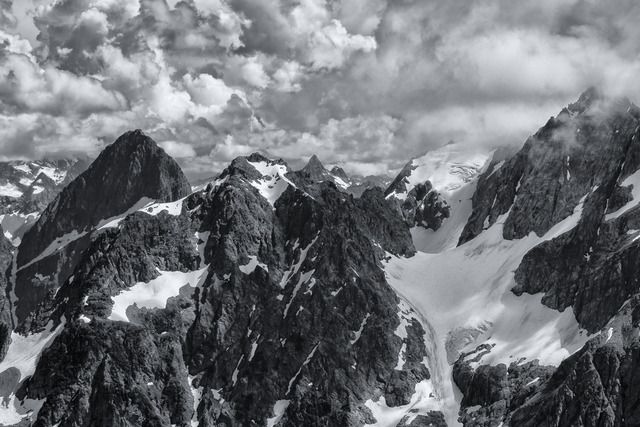
I am happy to keep this going. A "magical" place where I recently was:
Posted by: balzaccom
Re: Name this spot! - 08/24/16 01:23 AM
That looks cold and rugged. Alps? Norway?
Posted by: ndsol
Re: Name this spot! - 08/24/16 07:37 AM
That looks cold and rugged. Alps? Norway?
I should have noted that this is in the US in a state north of the Sierras. 😉
Posted by: balzaccom
Re: Name this spot! - 08/24/16 06:37 PM
Ah! That explains it.
Outside of my area of expertise--but it looks delicious!
Posted by: OregonMouse
Re: Name this spot! - 08/24/16 07:15 PM
Don't recognize the exact view, but perhaps the Picket Range in North Cascades NP?
Posted by: ndsol
Re: Name this spot! - 08/24/16 07:22 PM
Don't recognize the exact view, but perhaps the Picket Range in North Cascades NP?
It is in North Cascades NP, but south of SR20.
Posted by: OregonMouse
Re: Name this spot! - 08/24/16 09:31 PM
google done told me, but I won't reveal it--not fair, IMHO. I've never been to that particular area, or I probably would have recognized it.
Posted by: ndsol
Re: Name this spot! - 08/24/16 09:58 PM
Don't have to even Google to find it as I gave away the location from near where it was shot much earlier in this thread.
Posted by: OregonMouse
Re: Name this spot! - 08/24/16 10:38 PM
OK, it's Magic Mountain near Cascade Pass. Southern End of NCNP and near the Ptarmigan Traverse (which I've heard of but never done, not ever having been into climbing). I never have been to Cascade Pass, but I might try after seeing your photo!
Let's let someone else try, how about from the East or Midwest?
Posted by: JustWalking
Re: Name this spot! - 08/24/16 11:18 PM
Let's see if this works
Okay! Figured out a way. So this is in Idaho. Looking for the name of the lake, not the peak.

Posted by: ndsol
Re: Name this spot! - 08/25/16 12:20 AM
OK, it's Magic Mountain near Cascade Pass. Southern End of NCNP and near the Ptarmigan Traverse (which I've heard of but never done, not ever having been into climbing). I never have been to Cascade Pass, but I might try after seeing your photo!
Let's let someone else try, how about from the East or Midwest?
Yes, that is it, but you will have to get to Sahale Glacier Camp to see that view of (from left to right) Pelton Peak, Yawning Glacier and Magic Mountain.
A couple of photos from the tent site with one of the other sites in the second photo on top of another mound.
Posted by: OregonMouse
Re: Name this spot! - 08/25/16 03:07 PM
I keep forgetting that now that my beloved dog has passed on, I no longer have to avoid national parks. It's the national parks' anti-dog policy that has kept me away from Cascade Pass all these years. I definitely have to improve my conditioning before I can make it up there--not sure if that's possible at 80, but I'll try!
Thanks for the photos!
JustWalking, I've never hiked in Idaho, but that lake shore is purty!
Posted by: ndsol
Re: Name this spot! - 08/25/16 05:03 PM
Today is the 100th Anniversary of the NPS. It is too bad that the NPS still doesn't allow dogs in the backcountry. Here in Texas, dogs are permitted in our State parks and I have seen no issues.
With a group of 13, it is difficult to make any national park work. North Cascades is one of the few whose system makes it somewhat feasible, but we had a backup plan as we didn't want to travel 2,000 miles and then not find what we wanted.
Even laying down some ground work (and working through many permutations), I still spent an hour at the Wilderness Permitting Center in discussions/negotiations for our permits, but in the end it worked out as we wanted.
Posted by: ndsol
Re: Name this spot! - 08/30/16 02:29 PM
Though I have driven through the area, I have not hiked there. But I believe the lake may be the same name as the wilderness - Sawtooth.
Posted by: JustWalking
Re: Name this spot! - 08/30/16 03:30 PM
And so it is! Sawtooth Lake. Quite a climb to get to it, but a wonderful camping spot at the end of the lake.
Posted by: balzaccom
Re: Name this spot! - 08/30/16 03:42 PM
Wow. That means ndsol you are up again!
Where are you taking us now?
Posted by: ndsol
Re: Name this spot! - 08/30/16 10:55 PM
In honor of the 100th Anniversary of the NPS last Thursday, let's travel to one of our southern parks. This photo was taken last Christmas Eve. What I am interested in is not only the name of the park, but also the name of the prominent tall feature on the left, which is a backpacking destination:
Posted by: bluefish
Re: Name this spot! - 08/31/16 07:42 AM
Seems to be arid and perhaps NM or Tx. El Capitan? Haven't been but looked at the GMNP as a possible winter trip.
Gorgeous pic!!!!
Posted by: ndsol
Re: Name this spot! - 08/31/16 09:05 AM
Thanks. It is in Texas and one of its national parks, but not Guadalupe Mts. If you know how many national parks Texas has, then you will be able to know the park.
Posted by: balzaccom
Re: Name this spot! - 08/31/16 11:22 AM
So it's Big Bend National Park?
And the mountain? Chicos Mountains...Is this Nugent Mountain?
Posted by: ndsol
Re: Name this spot! - 08/31/16 11:32 AM
Yes, it is Big Bend and the mountain range is the Chisos (the only mountain range completed contained in a national park). Now I am looking for the feature on the left from which you can see Mexico.
This photo shows the view from that feature and the prominent feature on the right of the first photo is straight ahead in this one (extra credit if you can name it).
Posted by: balzaccom
Re: Name this spot! - 08/31/16 05:00 PM
OK--I'll give it another shot.
Punta de la Sierra....and the small peak in Elephant Tusk?
Posted by: ndsol
Re: Name this spot! - 08/31/16 07:01 PM
Elephant Tusk for the extra credit! Not Punta de la Sierra on the left, but since you got the harder one, you should post next. What I was looking for was the South Rim.
Posted by: balzaccom
Re: Name this spot! - 08/31/16 09:39 PM
Cool! Thanks for posting that one---now I have another park to visit.
OK---what about this one--looking for the name of the large granite chunk on the right:
Posted by: ndsol
Re: Name this spot! - 09/01/16 02:18 AM
Half Dome with the Merced River flooding.
Well, at least it's close to there.
Posted by: bluefish
Re: Name this spot! - 09/01/16 06:49 AM
Smith Peak? I wish I had gotten more than just a touristy minute view of the HH.
Posted by: balzaccom
Re: Name this spot! - 09/01/16 09:30 AM
well you're close...but so far, no cigar.
Posted by: Rick_D
Re: Name this spot! - 09/01/16 01:22 PM
Le Conte Point, isn't it? Sounds suspiciously French.
Cheers,
Posted by: balzaccom
Re: Name this spot! - 09/01/16 02:11 PM
Actually, LeConte Point ( Joseph LeConte was a professor of geology at the University of California--and was a slave owner in Georgia before that...) is the nice peak right in the middle of the shot.
But that should make getting the name of the thing on the ridge much easier.
Posted by: bluefish
Re: Name this spot! - 09/01/16 06:32 PM
My final attempt- Kolana Rock.
Posted by: ndsol
Re: Name this spot! - 09/01/16 06:51 PM
I believe that is correct.
Posted by: balzaccom
Re: Name this spot! - 09/01/16 07:51 PM
You got it, Charlie. It is Kolana Rock, which towers over Hetch-hetchy.
you're up. Where are you taking us?
Posted by: bluefish
Re: Name this spot! - 09/01/16 09:44 PM
I feel rather voyeuristic , having looked it up via map (I did immediately recognize it as Hetch Hetchy, but hey.... I could go all backyard and stick to the daks or Greens, but I think I'll do SW. Thanks , and I'll post something tomorrow.
Posted by: bluefish
Re: Name this spot! - 09/02/16 06:39 AM
We'll stick to the Sierra.
This wonderful travertine natural bridge is on a good route for a trans- Sierra adventure. What's the creek called and what is it famous for containing?
Posted by: balzaccom
Re: Name this spot! - 09/02/16 10:55 AM
Hmmmm. I can't see your photo.
Whoops. Now that I replied, I can!
Posted by: ndsol
Re: Name this spot! - 09/02/16 12:44 PM
Perhaps some Au trout are involved?
Posted by: bluefish
Re: Name this spot! - 09/02/16 05:01 PM
Perhaps some Au trout are involved?
Yeppers, hot on the trail...
Posted by: bluefish
Re: Name this spot! - 09/03/16 08:12 AM
Much to my dismay, the confluence of 2 creeks above the bridge had one of them gone dry! It's the one whose name is retained for the flows continuation. It's 100% gold, ndsol.
Posted by: bluefish
Re: Name this spot! - 09/06/16 05:02 PM
Sorry I put up a boring one. I'm out of here.
Posted by: ndsol
Re: Name this spot! - 09/06/16 05:13 PM
Sorry I put up a boring one. I'm out of here.
Not boring in the least, especially to a fisherman! Golden Trout Creek, which is the home to California's state fish, the Golden trout. The other creek that was dry would have been Volcano and the travertine bridges would have been near there on Golden Trout Creek? It's my understanding that Volcano Falls prevents other trout species from the main Kern River from mixing with those in Golden Trout Creek, which keeps the species pure.
If that is correct, then I will defer to anyone else that would like to post.
Posted by: OregonMouse
Re: Name this spot! - 09/06/16 06:56 PM
You can't expect a crowd here over Labor Day weekend!
Here's an old photo from the Pacific NW (hint,
very NW). The kids are now teenagers!
Posted by: ndsol
Re: Name this spot! - 09/06/16 07:05 PM
Sh! It's a secret in a National Park.

Posted by: OregonMouse
Re: Name this spot! - 09/06/16 07:43 PM
Right so far, but it's definitely not a secret!
Posted by: ndsol
Re: Name this spot! - 09/06/16 07:57 PM
Yes, it's definitely not a secret, but its name evokes being very upscale.

Posted by: balzaccom
Re: Name this spot! - 09/06/16 09:07 PM
OK. THAT'S funny. But it's somebody else's turn to post a photo. Shi sh....grin
Posted by: OregonMouse
Re: Name this spot! - 09/06/16 11:07 PM
Right, Shi-Shi (pronounced shy-shy) Beach in Washington's Olympic National Park. The rocks are part of Point of the Arches. Unfortunately I didn't get a photo that shows the arches. It was a strong minus tide, so lots more land showing than would usually be the case.
Posted by: balzaccom
Re: Name this spot! - 09/07/16 04:47 PM
Reminds me of a state park in California called Pi Pi. OUr children were enchanted with the idea that it might be pronounced pee pee. It's not. It's Pye Pye. sigh.
OK. I guess I am up?

What's the name of the island?
Posted by: Rick_D
Re: Name this spot! - 09/07/16 04:55 PM
I'm a yuuge Fannette of it.
Cheers,
Posted by: balzaccom
Re: Name this spot! - 09/07/16 06:16 PM
Bingo! IN Emerald Bay in Lake Tahoe.
Rick, you are up!
Posted by: Rick_D
Re: Name this spot! - 09/08/16 01:50 AM
Here's a pair of peaks tucked away in a remote corner of California's most popular national park, as viewed from perhaps the prettiest lake in the park. Definitely the most fjord-like I've been to. While many paths lead there, any of them takes work.
An alternate view from the lake's end.
Name either peak or name the lake.
Hope this isn't too obscure, but it's a chance to share a breathtaking spot.
Posted by: balzaccom
Re: Name this spot! - 09/08/16 11:04 AM
Not too obscure...but I'll let somebody else play for a while. If we don't get an answer in a day or two, I'll give them the keys to the answer.
Posted by: balzaccom
Re: Name this spot! - 09/12/16 12:04 AM
Nobody?
Posted by: balzaccom
Re: Name this spot! - 09/13/16 12:07 PM
OK. I am guessing Tilden Lake and Keyes Peak/Saurian Crest...
Posted by: skcreidc
Re: Name this spot! - 09/13/16 01:14 PM
Wow. You ARE good! Beautiful area too.
Posted by: balzaccom
Re: Name this spot! - 09/13/16 02:57 PM
Well, in this case, we've been there and done that.
How about this one:

There will be hints if they're needed....
Posted by: ndsol
Re: Name this spot! - 09/13/16 03:02 PM
Are we still in California?
Posted by: Rick_D
Re: Name this spot! - 09/13/16 03:07 PM
Winna, winna, chicken dinna!
Saurian to the left, Tower Peak to the right and Tilden Lake it is, the two pics were taken two years apart. Tilden isn't
too far off the PCT but the most interesting approach is XC across Tower Pass to the north. Mary Lake pictured below lies in a cirque below the pass, high above Tilden.
Based on the pic you would think it would be a quick trip around the lake, and you would be wrong. Trying the east shore if I ever go back.
You're up!
Ribbon Falls in Yosemite. Only flows in spring.
Posted by: balzaccom
Re: Name this spot! - 09/14/16 01:17 AM
Daisy got it without any need for a hint--and that means it's her turn to post a photo!
Posted by: OregonMouse
Re: Name this spot! - 09/14/16 12:06 PM
And I know she has lots and lots of beautiful ones!
OK, this is in the Wind Rivers and you can actually find it if you read the four trip reports I just put up on High Sierra Topix.
Posted by: balzaccom
Re: Name this spot! - 09/14/16 02:54 PM
Lovely. And a nice invitation to not only explore that area of the mountains, but also explore that area of the internet!
Posted by: OregonMouse
Re: Name this spot! - 09/14/16 10:08 PM
I found it, but I'm not going to reveal it because W_D's trip reports are so awesome! You have to read them!
Posted by: balzaccom
Re: Name this spot! - 09/15/16 12:44 AM
Nice! I agree you, OM.
But we'll give this a couple of days for someone else to enjoy the TR...and name that spot.
Posted by: skcreidc
Re: Name this spot! - 09/15/16 02:30 PM
Well, on the water fall shot I would have guessed Yosemite. I mean how could you not. But I would have had no clue it was Ribbon Falls.
Me checking this thread was pure kismet as I've been thinking about the Winds a lot lately. Wonderfull reports as per usual WanderingDiasy.
Posted by: balzaccom
Re: Name this spot! - 09/21/16 12:21 PM
Hmmmm. Seems like nobody else wants to play. So I am going to bump this up a bit and guess that it's Kagavah Lake....
And I wish I could accompany Daisy on some of her hikes in the Wind Rivers...
Posted by: skcreidc
Re: Name this spot! - 09/22/16 07:07 PM
Well, i was going to play, but I still can't figure out how to post up photos. Every couple of days I'll peck at it. At this point I'm still striking out.
Posted by: toddfw2003
Re: Name this spot! - 09/27/16 12:55 AM
tenaya lake
Posted by: balzaccom
Re: Name this spot! - 09/28/16 11:16 AM
Daisy, did I get it right with Kagavah lake?
Posted by: OregonMouse
Re: Name this spot! - 09/28/16 09:17 PM
I hope so--the photo matches her trip report!
Posted by: balzaccom
Re: Name this spot! - 09/29/16 11:12 AM
OK....so hearing no objections:
Name this spot:

Posted by: Rick_D
Re: Name this spot! - 09/29/16 01:01 PM
Unicorn Peak?
Posted by: balzaccom
Re: Name this spot! - 09/29/16 04:17 PM
Nope. Not Unicorn Peak.
Posted by: ndsol
Re: Name this spot! - 09/29/16 08:19 PM
Are we back in the Sierras again?

Kings Canyon perhaps.
Posted by: balzaccom
Re: Name this spot! - 09/30/16 12:16 AM
ndsol is barking up the right tree....
Posted by: bobito9
Re: Name this spot! - 10/01/16 12:12 AM
Kings Canyon? And all this time I thought it was in Egypt!
Posted by: balzaccom
Re: Name this spot! - 10/01/16 12:48 AM
You're spot on, Bobito, unless you think it is Pyramid Peak (in the Crystal Range, by Lake Tahoe.)
Do you want to put a name on this beast and post the next photo?
Posted by: bobito9
Re: Name this spot! - 10/01/16 04:25 PM
I am much too challeged by my inability to post photos here to take up the baton...besides, I just realized that the Temple of Cheops is actually found in the Grand Canyon, not Kings Canyon, right?
The Sphinx, Kings Canyon CA
Posted by: balzaccom
Re: Name this spot! - 10/03/16 10:46 AM
Thank you, Daisy.
It's your turn to post something!

The first one is pretty obscure. Only "Sierra-holics" will get it. So I put a second photo that is better known.
Posted by: OregonMouse
Re: Name this spot! - 10/05/16 11:50 AM
No idea for either (although the seond is obviously in the southwest). However, I'm really impressed by the size of that dike intrusion (I hope I used the correct geological term!) in the first photo!
A hint. The bottom photo is a national monument, more of a day-hike destination than a backpack destination. A fairly large town is quite close.
Posted by: balzaccom
Re: Name this spot! - 10/05/16 06:27 PM
I bet I know the answer...but the odds are against me. In roulette, I usually bet black on black.
Posted by: OregonMouse
Re: Name this spot! - 10/06/16 01:32 PM
I found that one with some online searching. IMHO, that's kind of cheating, so i won't reveal it. Anyway, balzacom is ahead of me!
I'm waiting for revelations on the first photo--that is such an impressive formation!
Posted by: skcreidc
Re: Name this spot! - 10/09/16 12:16 PM
This has been up long enough that I will guess. But be forewarned, like bobito9, it's been years since I could post photos to this site. One of the reasons I disappeared for a while.
So , my guess for the top pic is of the roof pendant complex that extends up past the Convict Lake area. The folds in this metamorphic unit are really wonderful and I think this picture is from the mountains south of the lake.
The second I'm just going to leave at the "Windgate Formation". If not, it's a dead ringer for it.
Posted by: OregonMouse
Re: Name this spot! - 10/09/16 06:21 PM
Thank you, skreidc! On a large (i.e. half of California) map, about where would it be located?
If nobody guesses the second photo by Tuesday night I will reveal what I learned on the internet. It's not quite where I expected it to be!
Posted by: skcreidc
Re: Name this spot! - 10/09/16 09:18 PM
Hi OM. I'm not 100% sure it is this spot, but I know I have seen this area before sometime in the 1980's. Convict Lake is located just South of Mammoth and is right along the East side. It is the immediate access to Laurel Mountain.
The other spot I think is Arches. The rock in the pic looks just like Indian Creek, just less fractured.
Posted by: skcreidc
Re: Name this spot! - 10/11/16 11:46 AM
This is a test to see if I can actually post some of my photos up, and it shows the rock formations of the Indian Creek area that I was talking about...I hope
[img:left]
https://goo.gl/photos/zCTRubmCScPP6mdF7[/img]
Nope. Don't have it yet.
But I do seem to be able to create a link to a album.
typical of forums... pictures take up too much bandwidth. the work around is to post your pictures to a hosting site and then post the link to that pic, to the forum. there's lots of hosting sites...some require a fee and some are free
Sorry, I have been out of town. Yes, you are correct! I came into this area from McGee Lakes, that is how I am looking down on that formation. That entire area is absolutely amazing with colorful rocks, where you would not expect them.
The second photo is Colorado National Monument. I simply camped here because it was convenient. Never would have planned a trip here but was pleasantly surprised.
Posted by: balzaccom
Re: Name this spot! - 10/11/16 06:15 PM
Posted by: skcreidc
Re: Name this spot! - 10/12/16 11:26 AM
Balzaccom. I get an error when I try to look at your photos. You all can see the single photo I have on my link, right? Just trying to get this photo thing figured out.
And, my second guess should have been Canyonlands, not Arches. Still wrong, but WD thanks for making me aware of the Colorado National Monument. Patty and I have even spent the night in Grand Junction too after coming up from Durango.
Posted by: balzaccom
Re: Name this spot! - 10/12/16 11:38 AM
I hate Google Photos.
I repeat. I hate Google photos.
whew. OK.
Try this link to the photo:
https://goo.gl/photos/Gv8pPF98mtHeAKpN9And this one to the whole album:
https://goo.gl/photos/pPvZsiYE43bAFUHt8
Posted by: skcreidc
Re: Name this spot! - 10/12/16 11:52 AM
^^^^That's not very encouraging
Step one in posting photos; Don't use Google photos. oops, too late
edit; Yup. Convict Lake, and you can see the fold in the mountain behind the lake.
Posted by: balzaccom
Re: Name this spot! - 10/12/16 02:10 PM
I didn't choose Google photos. I used to have all of our photos on Picasa, and that worked great, and linked directly with the Google Sites software that I used for our website, which is why I chose that combination.
Then Google transferred everything over to Google photos automatically, and really gave me no option. And they make it very hard to share photos publicly. And none of the hundreds of the photo links on our websites work now...
Did I mention that I hate Google photos? I hate Google photos.
I do have individual photo files for each shot. Is there a way to post those directly onto these boards, instead of a link?
Posted by: skcreidc
Re: Name this spot! - 10/12/16 02:28 PM
Wow. Sounds just like my situation.
Well, in the spirit of this thread I will do what I can to continue on
So, there is a via ferrata on the East side of the U shaped valley with this town nestled in it. The first time I had ever been to this town was to get on this "iron way" or via ferrata as they are known in Italy. I figure that is a large enough hint for now. Here is the link to some photos; [img]
https://goo.gl/photos/WZDTWzswNm2p4Tnk6[/img]
Oh, not in California.
edit; at least I can link an album.
Posted by: balzaccom
Re: Name this spot! - 10/13/16 12:20 AM
is this the one in Telluride?
Posted by: skcreidc
Re: Name this spot! - 10/13/16 09:35 AM
I think it's tough to get much past this crowd here. You are exactly right Balzaccom, Telluride it is! It's a big traverse along the wall. I guess you are "up" again
I tell you, those mountains east of Ouray (I know that's not Telluride but close enough).....they look very inviting to go visit!
Posted by: balzaccom
Re: Name this spot! - 10/13/16 01:55 PM
OK. Try this one. I can't use any of my own photos on Google Photos. Did I mention I hate Google Photos? (Just testing Google's own SEO technology!)
So here is the photo:
What is the name of the peak---and why is it called that? The story is amazing.
Posted by: skcreidc
Re: Name this spot! - 10/13/16 07:39 PM
Hoo boy.....I'm pretty sure I've never seen that outcrop before. I'll have to do some research to figure this out. Your going to have to give me a couple days balzaccom
Maybe I can figure out this photo posting too.
Posted by: balzaccom
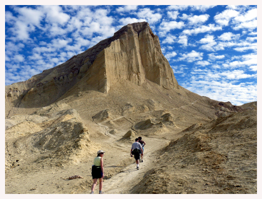
Re: Name this spot! - 11/03/16 11:27 AM
OK. Looks like nobody is going to guess this one. The mountain is Manly Beacon in Death Valley. Not the highest peak by a long shot, but one with an amazing story--told here with help from Wikipedia.
In 1849, at age 29, William Manly joined the thousands of American Forty-niners traveling to California to participate in the Gold Rush. He began traveling overland from Wisconsin.
Upon reaching the Green River, just west of South Pass, Manly and a half dozen other men tried to float to California by floating on an abandoned ferry they found down the Green to the Colorado River, then on to California. To fix the planking on the boat, they had to chop down trees and form the boards with their hand tools.
As had William Ashley done almost 25 years previously, they put in the river in Wyoming, and floated through the canyon of the Gates of Lodore. But, unlike Ashley, who disembarked at the mouth of the Duchesne River after experiencing the treacherous canyon, Manly may have traveled further down, to present day Green River, Utah where the Old Spanish Trail crossed the river.
Wherever they did disembark, they were met by Chief Walkara, who helped them to travel overland to the Wasatch Front. And this kindness was not forgotten by Manly. It was twenty years later, 1869, that John Wesley Powell's party was successful in floating further down the Green to the Colorado, then on to the California/Arizona border.
South of present-day Provo, Utah, Manly joined other Forty-niners traveling to southern California, including two families with small children. In December, these pioneers became lost in the Great Basin Desert, and entered Death Valley having followed an inaccurate map for three weeks. Remembering Chief Walkara's help, Manly argued strongly against raiding the Indian food caches that these 49ers found along the route, although his arguments were largely ignored.
Their food supplies were almost exhausted, and the oxen pulling their wagons were dying of starvation. The families stopped at Furnace Creek in Death Valley. They could go no further.
Manly, with his associate John Haney Rogers, trekked 250 miles on foot across the Mojave Desert to Rancho San Fernando near Los Angeles, California, to scout an evacuation route for the families trapped in Death Valley, and procure food and horses if a settlement could be located.
They arrived, nearly dead. But once in San Fernando, Manly took only two days to use the funds to buy supplies, and then hiked back the 250 miles to Furnace Creek to rescue the remaining members of his party. Once he got to Furnace Creek, he gave the group only a few days to prepared, then led them BACK over that same 250 mile route to safety.
Manly himself had hiked 750 miles over the most torturous terrain in North America on a mission of mercy to rescue the families at Furnace Creek. While a couple of the older men in the party died, Manly managed to rescue all of the women and children.
Manly Beacon is a tall white mountain that projects out above Furnace Creek near Zabrisky Point, and so it served as his guidepost to find the families he had left there.
In the compilation of his memories, Manly contacted all the relevant persons possible, then with the aid of a publishing assistant wrote the greater part of his autobiography, "The Death Valley in '49," published as a book in 1894. The title was changed to "Death Valley in '49," ostensibly to encourage sales, although Death Valley is only spoken of in the tenth chapter.
The book is an excellent read. In it, Manly recounts how, as the Bennett and Arcane families began their climb out of the valley through the Panamint mountains south of Telescope Peak, someone in the group, probably Sarah Ann Bennett (née Dilley), or Mrs. J.B. Arcane, turned to take a last look eastward and said "Goodbye, Death Valley!"
Mrs. Bennett, upon her death bed many years later, sent word to William Manly that she would like to see him once again before she died. He immediately left Southern California to race northward and was able to visit with her just a day before her death in San Jose. She always called him the Guardian Angel of her children.
They don't make men like that anymore.
Posted by: OregonMouse
Re: Name this spot! - 11/03/16 11:41 AM
William Manley's account,
Death Valley in '49, is a fun read and is available online:
Death Valley in '49
Posted by: Rick_D
Re: Name this spot! - 11/03/16 02:56 PM
What a tale!
Posted by: wahahazx1
Re: Name this spot! - 12/07/16 09:30 PM
Posted by: 4evrplan
Re: Name this spot! - 01/15/17 09:28 PM
This really needs to be a movie.
Posted by: balzaccom
Re: Name this spot! - 01/16/17 12:35 AM
I agree. Way better than most movies plots that get made into grand feature films!


