First off, just a quick hello to everyone being this is my first post. But my real intention of this post is to get input on my summer trip. I have spent many a (long) weekend camping and hiking over the years, but due to my proximity to the AT, it pretty much can all be described as the typical "green tunnel," the exception being one trip to Saskatchewan when I was younger.
However, because of my new job, I finally have the ability to take long vacations. My plan is to take a week to backpack in Yosemite, the issue being that I really don't have any first hand knowledge of the trails. I don't know anyone personally that has done anything but a day hike there. I'm planning on getting a wilderness permit for either July (after the 4th, of course) or August. Pictures and articles are nice and everything, but nothing beats getting information from people who have actually been there.
I would just like some advice as to what trail heads I should apply for to be able to include Half Dome (the NPS site states something about "appropriately" planning in Half Dome in my request so I can get a permit for it too) and what other places people really feel are a must see. I know I could come up with an itinerary by myself, but I'm not above asking for help.
We cannot offer much help without more information from you. Do you want to stay on trails or is a bit of off-trail OK? How many hours per day are you willing go hike? Are you in great physcial shape or average? What kind if terrain do you like- high alpine, lakes, trees, woodsy, open views? What is your desire for solitude? Some of the most scenic areas in Yosemite are well used. Yosemite is a big place with lots of variety.
I'm all for visiting places off-trail. While I haven't hiked extensively off-trails, I have done it and always had fun doing it. Even though I know it's a false feeling, it's fun thinking I'm exploring some place that few people really see. I generally measure my hikes in distance instead of time (aprox. 15 miles being what I can do comfortably), but the longest I went between camps was 14 hours, though was mostly because of weather and other circumstances made it very slow going.
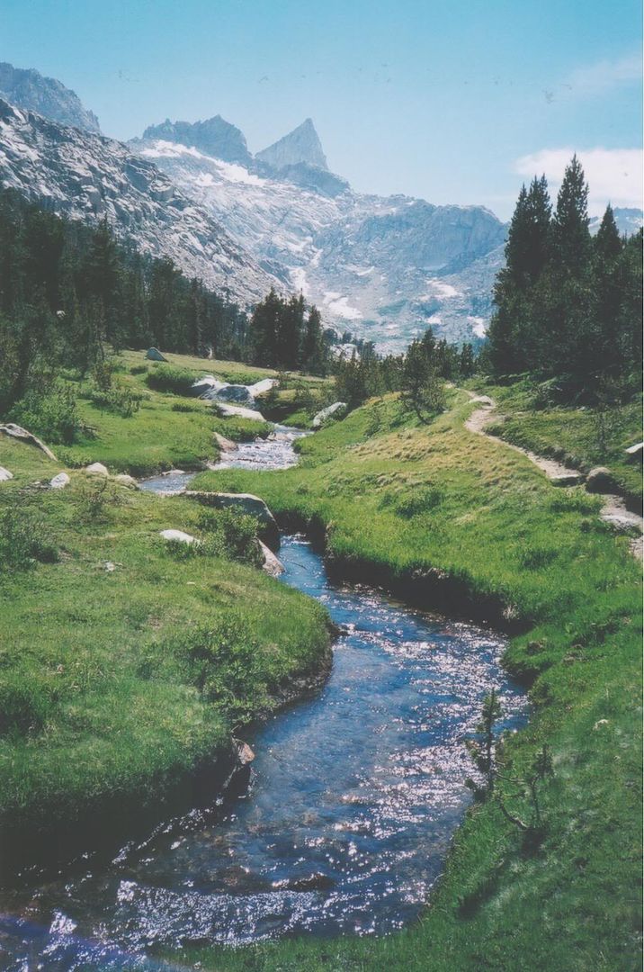
I will admit I'm not in as good a shape as I was in school. Since I've started hiking by myself, I've cut my gear a lot and find I'm able to go much further now by myself then with a partner that isn't having quite as much fun as me. Like I said, the Appalachian environment is really what the majority of my experience is, and while I love it, I do want to see the wide open views that simply can't be had over here. It's why Half Dome is at the top of my list.
Solitude kinda goes both ways for me. I will be going by myself, but it's mostly because the two friends I would go with, can't go. That's really something that only matters to me when it comes time to bed down. I know the most scenic places will be well traveled and generally have no issue with that, but I really don't want to have to sleep in a crowded place if I can help it.
In Yosemite, you have to consider travel time, not just miles. Particulary if you start out in the Valley you can easily gain 5,000 feet in a day. There is not a lot of flat walking in Yosemite. You need to esitmate about 1 extra hour for each 1,000 feet of elevation gain. And if you go off trail you will go about half as fast. The trails are mostly in good shape in Yosemite so you can make good time on the trails. I typically do about 3,000 feet of elevation gain a day. 10-12 miles on trail is a reasonable distance. Off-trail I do more like 7 mile a day.
It can be REALLY hot in the summer in the Valley. In fact, at most elevations below the Valley rim (about 7,000 feet) it can be almost too hot to comfortably hike in the late afternoon.
There is a once-a-day each way shuttle bus service between Tuolumne Meadows and the Valley (YARTS bus service) that is really reasonable. This allows you to do some really nice one-way hikes. There is also free shuttle bus service in the Valley between Valley trailheads and bus service between a few of the different trailheads at Tuolumne. These free shuttles go about every half hour. There is a more expensive bus (about $22)between Yosemite Lodge and Glacier Point. So all this bus service leaves you LOTS of good options. The YARTS schedule is on the internet. The other bus stops are described in the Yosemite NP website.
This summer could be quite dry with early melt. So far we are really in a drought. Unless the weather changes, there will be much earlier access this year and earlier peak runoff. This is good for backpacking because many streams are not crossable at peak. This year you probably will not have any stream crossing problems. In fact many may dry up, so you have to watch your water sources.
If you cannot get a HalfDome permit, just do Cloud's Rest- it has just as good a view and no permits required.
Just check some of the trip reports here and you can get some good ideas. I recall there are several. If the search function does not work well, just scroll back- you will find some.
I've actually been leaning towards starting at Glacier Point down Illilouette then turn towards the Valley/Half Dome. Whether I could do Half Dome or not, Clouds Rest was going to be the next stop, was just going to do Half Dome the day before if possible. But after Clouds Rest I really was out of ideas. I wanted to find some way to loop back around to Yosemite Falls, but not real sure how to go about that. While heat has never caused a problem for me, becoming dehydrated is really ever my one worry about going some where new.
Due to transportation arrangements, I have to some how get back to the Yosemite Valley Wilderness Center. I knew of the shuttle service, but wasn't aware of the once-a-day run between the Valley and Tuolumne.
One thing I've been confused about though is the time limit of a wilderness pass. I thought I read on the NPS site that you could only apply for one no longer than 7 days, but of course now I can't seem to find that. I've been told however that they can be up to a month. I was planning on applying for 9 days.
How may days were you planning on? The trip you describe, given the mileage you want to do, is a one to two day trip!
I personally think your trip is too low elevation for mid summer if you want to do long days. You are going to ROAST! I would start in the high country, and then walk out to the Valley. At least you would be going downhill in the heat. One of the best things to do in the heat is to walk down the Mist Trail. You get wonderfully soaked by the falls! Do not believe the nay-sayers who say you cannot do that trail with a pack on. Just take it easy. But, if you are into a leisurely trip with lots of swimming breaks, then staying low is OK. I did the Grand Canyon of Tuolumne late Aug in the heat stopping just about at every pool for a dip. We did not make good time, but it sure was fun.
Here is a 7-9 day suggestion. You have to work out the miles and see if it is feasible for you.
Tuolumne to Vogalsang Lake area, side trip to Townsley Lake. Over pass, side trip to Bernice Lake, camp on Lewis Creek.
Upper trail to Lyell Fork (this stretch can be dry late season). Mod difficult off-trail side trip to Hutchins Creek Lakes - takes a whole day to really explore this area.
Take a day to explore upper Lyell Fork lakes.
Trail to Forester Creek. Easy off trail to Harriet Lake. Moderate off-trail to lake below Isberg.
Down to Tripple Divide trail junction. From here you can either go via Washburn/Merced Lake and on down to Little Yosemite Valley. Or go over Red Peak Pass via Ottoway Lakes and then come back along Illowcette Cr. 2-3 days for all this.
If going over Red Peak Pass, then go towards Little yosemite Valley on the Panorama Trail.
From Little Yosemite Valley you can climb either Half Dome or Clouds Rest.
Leisurely day down to Happy Isles. Stay in Backpackers Campground in valley. Do some day hiking up Yosemite Falls. Bus back to car at Toulomne.
Or you could walk back to your car via Snow Creek Trail.
Forgot to mention- you can easily spend several days in Yosemite Valley day-hiking. You get to stay in the Backpackers campground the night you come out. Then you can go over to Camp 4 (shuttle bus service easy to get there) and stay other nights. Camp 4 is a group shared campsite that cost $7 per person per night. It is a no-reserve, first come campground. Not too hard to get a spot if you go over early, weekdays (not Friday though). Most of the hikes out of Yosemite Valley are actually better done as day hikes.
I've actually been leaning towards starting at Glacier Point down Illilouette then turn towards the Valley/Half Dome. Whether I could do Half Dome or not, Clouds Rest was going to be the next stop, was just going to do Half Dome the day before if possible. But after Clouds Rest I really was out of ideas. <snip>
Due to transportation arrangements, I have to some how get back to the Yosemite Valley Wilderness Center. I knew of the shuttle service, but wasn't aware of the once-a-day run between the Valley and Tuolumne.
If you absolute love high up views - there are higher places than Half Dome. That's the worst place to go if you want to get away from people, and one of the lower places to go as well.
Mt Dana, Mt Hoffman, Clouds Rest, any of the domes up around Tuolumne Meadows... walk ups at higher elevation. NO permits, NO crowds. Dana is my new favorite place, with Alta Peak (Sequoia NP) as a close second.
The route you describe here will be HOT. Glacier Point to Illouette to Nevada Falls to Half Dome is a HUGE first day pull - there is no camping!!! until you reach Little Yosemite Valley and the designated spots there, and the majority of the trail is exposed, very few trees, thanks to a few wildfires some decade or two ago. The alternative first day is to go to Illouette Creek and head upstream until you are four trail miles from Glacier Point, where you can legally camp. A very easy first day and then you backtrack two miles to get back on trail.
If I had your priorities I would go in from the Big Oak Flat trailhead - easier to get permits for. Plan to get the permit and stay the night in the valley backpacker camp, then jump on the hiker bus and get off at the trailhead first thing in the morning. Should take 20-30 minutes to get there from Curry on the bus. Book it up the exposed part of the trail before 10-11 am into the trees. Hike the north rim, going to the tops of El Capitan, Eagle Peak, Yosemite Falls, North Dome, Mt Watkins - you will have unparalleled views of the valley, Half Dome, etc. and hardly anyone (relatively speaking, this is still Yosemite and there will be people!) around.
It's about 30 miles with roughly 9,499 feet of elevation gain (cumulative, not all uphill, there are ups and downs along the way) to Tenaya Lake on trail - you cannot get off the trail on the road and take a shuttle - the minute you travel along a road you are out of the wilderness and the permit is no longer valid. So you would be hiking the north rim route to Snow Creek and continuing on trail to Olmsted Point, and beyond it to Tenaya Lake. Then you would have Clouds Rest, Half Dome and eventually Happy Isles in front of you going mostly downhill after Clouds Rest - about 16 - 18 miles depending. Highest points are going to be after Olmsted Point at 8,500 - which is about the same elevation as Half Dome, btw, and right on Tioga Road, so there will be tons of people there - the junction of the Clouds Rest Trail with Sunrise Lakes trail (go off trail to the top of the point here at 9,242 feet for excellent views of Tenaya Canyon), the top of Clouds Rest at 9,926 feet. And then it's all downhill, then uphill to Half Dome at 8,938 feet.
Nine days would make this a pretty slow trip. I would be going about 10-12 miles per day - but I hike in the Sierra all the time.
If you have never been to the Sierra, or hiked at higher elevations, it may be harder for you than you think. Starting at Big Oak Flat puts you at about 4,800 feet to start and goes higher from there. By the time you hit Eagle Peak you should be acclimated. You should read up on elevation sickness just the same since the only cure is to descend, and you need to be aware of it to do anything about it.
I should also add that if it's cloudy and rainy, do not go up any high point at all whatsoever. Lightening strikes the high granite places every month of the year. If you see what look like potholes in the granite slabs - those are where lightening has dug holes in the granite. Better to take a pass on one high place and live to climb it another day.
There are many bail out points - if you got to Yosemite falls and decided a couple of days was it, the elevation was getting to you, or the bugs, or whatever - you could hike down the trail there and hop on a shuttle back to Yosemite Village. If you got as far as Snow Creek junction that trail descends steeply to the valley as well. If you got all the way to Olmsted Point it would be easy there to hop on the free Tioga Road shuttle to Tuolumne Meadows, where there's a campground and the Lodge and store and the buses all stop, and make your way back to the Valley. If you had to spend the night waiting for a bus, the backpacker campground is the same as the one in the valley - walk in, bus in, bike in, it's $5 per night per person.
_________________________
"In the beginner's mind there are many possibilities. In the expert's mind there are few." Shunryu Suzuki
If we do not get a lot more snow, this summer there may be water source problems doing the north rim from Big Oak Flat. I still think it is too low. The sun really beats on the north rim. I am a real shrinking violet! 7,000 feet is even to low and hot for me in mid-summer. That is why I did not suggest the Pohono Trail (south rim)- which has more viewpoints than the North Rim. Both are more spring hikes than summer hikes. My vote is to take the bus up to Tuolumne, start here,stay high, and then just come back to the Valley the last few days. This leaves the heat to downhill sections only. You could luck out though. I remember one summer we were climbing up at Tuolumne and it was unually cool so we quickly drove down to the Valley and did Royal Arches. Because nobody does this very popular route in the summer we had it all to ourselves! I also nearly died of dehydration and heat exhaustion on doing a route on North Dome in June, the day the weather turned hot. The "spring" on the top was bone dry. We were on the rock wall all day in 90 degrees being roasted by the sun.
Another suggestion- if you are going solo, I have never found it that difficult to get a walk-in permit. So even if you get a reservation, you can probably change routes when you get there based on the weather. You may want to have a "PlanB" for overly hot weather or if your planned on water sources are dry.
Another option, since you mentioned going off-trail, is that the Nelson Lake Trailhead out of Tuolumne Meadows almost ALWAYS has availability. It's an easy hike from Nelson up past Reymann to Vogelsang, and from there you can tie into Daisy's itinerary.
We did a chunk of this last year---it's on our website.
Ha, see that's why I wanted to hear from people familiar with the area. I was giving myself more time between points of interests cause I was unsure of the quality of the trails and what kind of mileage is really possible. While I do feel confident in my capabilities, I also have first hand experience that I can be overconfident. I generally expect myself to do a couple miles less than those experienced in an area. Sometimes being cautious, but more often than not just because I know I'll be gawking at everything around me when I'm somewhere new. I will admit though, that I haven't hiked at some of the altitudes I will be reaching in Yosemite. And I actually was looking forward to some swimming opportunities while I was there.
Obviously I should have started some planning a little earlier and maybe done an earlier trip, but I'm sort of stuck with July/August cause I plan on getting a new tent and a few other things and I wanted to get some weekends in with it all before I decided on what to take.
The Big Flat Oak route that lori describes is pretty much what I came up with initially, just in reverse. I wasn't aware the area of my planned start would be quite that exposed. However, the more I read from everyone's posts, it seems like I'm limiting myself with the Half Dome thing.
Honestly, I'm probably going to have to flip a coin to see what routes get priority after looking more into the areas described. I'll be starting on a Monday so I'm not really too worried about not getting a pass on the dates I have picked out.
I may considering taking an extra platypus bottle or two if water is going to be more of an issue this year. Like I said, really the thing I worry about the most. And leaving myself exposed on at a somewhat high altitude during some "mild" weather is what I was referring to about overconfidence. You can bet I will be avoiding that experience again if at all possible.
I really do appreciate the input from everyone. I know dealing with lots of questions can be taxing. I did manage to find some trip reports by some of you, kind of what is making me reconsider doing Half Dome at all, at least on this trip. Reading your comments have only managed to make me even more excited, the problem being I'm tempted to bring more camera gear than I planned. I definitely have some ideas for vacation next year now if my others fall through. If I didn't have a silly wedding to go to in the spring, I would have even more days to burn this year.
I did a week-long Yosemite trip late last August, I spent 1 night at the Tuolumne Meadows campground, and three nights backpacking (then two nights camping in the valley with my family).
The plan was to do a loop south of Tuolumne Meadows... heading SW down the John Muir trail through Cathedral and Sunrise lakes, up to Cloud's Rest, then head east through Merced Lake and back north via Vogelsang.
However, after the first day I changed those plans, because I got going late and wasn't making the time I wanted. I could have done the loop, but would have had to sacrifice Cloud's Rest which I really wanted to hit. So the first night I stayed at Cathedral Lakes, the second at lower Sunrise Lake, the third day I hiked up to Cloud's Rest then back to Sunrise Lake where I stayed again, and then the next day hiked out via Tenaya Lake (there's a regular shuttle that goes between popular spots around Tuolumne Meadows pretty often during the day which took me back to the wilderness office).
I ended up only backpacking for 4-6 hours each day, but it was much more relaxed and enjoyable. I was able to do a bunch of mini-day hikes out of each camp site when I arrived. I also have a ~50 pound pack, so I'm not going to do 20 miles a day anyway. I think I did 30 miles over four days... the last day was a quick hike out, so it was really around 27 miles over 3 days.
There were people which I expected since I was within day-hiking distance most of the time. The quietest day was the second when I hiked between Cathedral and Sunrise lakes, when I only ran into 6 or so people while hiking.
Elevation wasn't a huge issue, and I'm a smoker who lives at sea level (although also only 28 years old). The first night camping at Tuolumne probably helped, and the second day on I felt great (first was a little tough).
Cloud's Rest was absolutely worth it, and the lakes were beautiful.
Also, my best advice is to buy your own bear canister (or at least give yourself time to pack a rented one), unless you're really good at carrying minimal supplies. I had a tough time fitting everything I needed (or thought I needed) into the one I rented, and would have rather had it at home ahead of time so I could practice packing it.
Edit to add:
Check reservation dates... they open months early and sometimes reservations sell out quickly, especially for campground sites. If you can't get a reservation for wilderness permits you're not completely out of luck, they save half for first-come first-serve, but if that's the case have secondary trips ready.
#164732 - 04/08/1209:40 AMRe: Help Planning Yosemite Trip
[Re: crust_tea_socks]
Gaucho
member
Registered: 07/26/10
Posts: 31
Loc: California
If your lucky enough to attain a backpacker�s permit for Half Dome, you can avoid day hiker crowds by getting up before sunrise and making your way up. Crowds usually start forming as early as 9am. The light is much more pleasant early morning anyway. There are off trail camp sites before the shoulder you can find. Be careful not to camp right by the shoulder of the dome, they�ve been cracking down and handing fines.
For those who have no experience with bear cannisters, I believe there have been some posts on how to pack a bear can in the food forum.
A few basics: If you use packaged fd food, poke a small hole with a pin at the top of the bag and squeeze out the air. If the package is going to be used as a bowl (pour in hot water) obviously do not poke a hole in the bottom or side!
With regular store-bought food, re-pack in plastic bags. You can suck excess air out of the zip lock bag by using a straw. No boxes, cans, or extra packaging.
Pay attention to bulk. Couscous, orzo and rice pack very well; large shaped pasta does not. Gorp, squishable trail bars, peanuts, sunflower seeds, almonds and single wrapped cheese sticks work better than fragile crackers or a loaf of bread. Flexible flour tortillas work well.
Only take what you need! Remember that you only need trail food and dinner for the first night and can easily do with just breakfast for the last day.
Since other "smellies" such as toothpaste, sunscreen etc have to go in the bear can at night, only take the exact amount you need and only necessities. The small "travel size" samples that you can buy at any store work well.
With properly selected food, that is re-packed, you should be able to get 7 days food in the standard bear cans that you rent from the park. If you do not own a bear can, you can buy one of those large $5 round tin cans of popcorn and practice packing food into that (after you eat all the popcorn, of course). Remember your high school geometry and calculate the volume of the popcorn can and compare with the advertised volume of the bear cannister.
I believe that we have posted this before--but it's still fun. From our blog:
Packing the Bear Can posted Sep 21, 2010 11:22 AM by Paul Wagner [ updated Sep 24, 2010 9:54 AM ]
It's not a science, but more like an art.
Step One: First you have to get all of your food together: the freeze-dried dinners, the soup packets, the instant oatmeal and cocoa, the energy bars and the gorp, the dried fruit and salami, bread or crackers. It all has to go into that little plastic barrel.
Step Two: Take everything out of its pre-packaged wrapper. Pour the freeze-dried dinners into zip-lock bags, so they take up less room. Open the dried fruit packages, squeeze all the air our of them, then re-seal them with their finger seal. Remove all extraneous paper wrappings, cardboard, etc. If you are taking bread, squeeze it down into a much smaller dimension, and then put it in the freezer over night. It will take up less room, and stay fresher that way.
Step Three: take the first night's dinner and set it aside. It doesn't have to go in the can, nor does the first day's lunch or snack. Whew! That makes it a little easier.
Step Four: imagine all of this fitting into that little plastic can. And imagine how you are going to use this stuff. Start by putting a couple of days' breakfasts and dinner down into the bottom of the can. You won't need these for the first few days, and it's better to get them out of the way.
Step Five: Now stack all those energy bars around the side of the can. This is the most efficient use of space for these bars, and this way they are more or less easy to grab. As you stack them in there, use more breakfasts or dinners to hold them in place.
Step Six: now it's time for the stuff in the middle. Take your salami, cheese, and anything else you are going to eat for lunch and pack it in the middle of the can. You'll need to access this stuff every day, so there is no point putting it in the bottom.
Step Seven: Toss in the last breakfast--that's what you'll need first thing in the morning on the second day, and it makes sense to put this on top. Hooray! It all fits perfectly!
Step Eight: Inform your wife that the bear canister is now packed for the trail. She asks if you want to put the toiletries in there as well.
Step Nine: Take the sunscreen, moisturizer, insect repellent, toothpaste, and face cream from your wife. Go back to the bear can and start shoving it in. With a little bit of luck and some brute force, you'll be able to wedge this stuff in between the salami and the cheese, and maybe shove one down the side with the energy bars. That last tube of face cream is just going to get mashed on top...and let's hope it doesn't jam the lid when you try to unscrew everything.
Step Ten: Inform your wife that the bear canister is now packed for the trail. She asks if you remembered the bread.
Step Eleven: Take the bread out of the freezer. Unpack the entire can and start again, shoving things together even harder. Forget trying to keep the noodles in once piece. Sacrifice the crispy crackers and turn them into powder to gain more space. Mash the bread into a solid ball, then shove the final toiletries on top and jam the lid in place. Slowly screw the lid down, listening for structural failure in the bear can.
Step Twelve: Inform your wife that the bear canister is now packed for the trail. She asks if you remembered to put the soap in.
Step Thirteen: Put the soap in a side pocket of your pack, along with the last two energy bars, a tube of neosporin, and the raisins your wife just bought at the store.
Step Fourteen: Inform the ranger at the trailhead that all your food and odorized items are in the bear can.
Step Fifteen: Start hiking. Hope for the best. Inform your wife that next time, we'll have take less stuff.
Our long-time Sponsor, BackcountryGear.com - The leading source for ultralite/lightweight outdoor gear:
Affiliate Disclaimer: This forum is an affiliate of BackcountryGear.com, Amazon.com, R.E.I. and others. The product links herein are linked to their sites. If you follow these links to make a purchase, we may get a small commission. This is our only source of support for these forums. Thanks.!


 Previous Topic
 Index
Index


