It's a magical place but so difficult to plan a trip in! A few years ago my son and I spent a night at a north rim campground and got a reservation at a south rim hotel for the next night. It was easy to plan since there were no permits involved but it was frustrating rushing through such beautiful country. We'd like to try again but spend a night or two below the rim this time, it's just so hard to plan when the assignment process is so random and laggy. The best approach I can come up with is to create a whole bunch of itineraries, put the &^*%# form in the mail, and hope for the best. Do any veteran GC hikers have suggestions? I've noticed that there seems to be at least one area with non-assigned-site camping...
One thing about reservation systems, a lot of people reserve and then drop out. So there are some permits if you are willing to wait to get a "no show". Best to avoid busy season. We went in November once- it snowed on the rim and many who had permits bailed out. We got a permit for the next day and also got a campground spot, because the campground campers also bailed out! By the time we got to the bottom it was a nice 75-degrees.
Not sure how things are now. You should call the rangers and talk to them about their current "no-show" policy.
It is very hard to get a reserved permit to climb Mt. Whitney here in California- it is a lottery (cost $30 too). I simply wait until after Labor Day and am flexible- and every time I get a free no-show. It may be for the same day, so you have to be ready to go. Or it may be the next.
#197034 - 12/04/1601:16 PMRe: Grand Canyon planning
[Re: 41253]
Pika
member
Registered: 12/08/05
Posts: 1814
Loc: Rural Southeast Arizona
Your best bet for getting a permit is to be flexible about start dates. I visit the Canyon 1-2 times per year and have not yet failed to get a permit for an itinerary near my request.
What to do? First, I don't bother faxing in my request; it is a frustrating process at best. I download the permit application form and fill it out with an itinerary that avoids any of the "corridor" camp sites such as Indian Gardens. At the bottom of the form is a space in which you can enter a range of start dates and other potential modifications of your itinerary. Fill this out using as much flexibility as possible. I usually enter at least a two week start date window and also alternative campsites such as Hermit Rapids rather than Hermit Camp or Granite Rapids rather than Monument Creek. I then mail the form to the backcountry office aiming at getting it there a day or so before the first of the appropriate month. The permit request cannot be made more than four months before the planned trip. So, if you wanted a start date for this coming April you should have mailed or FAXed your form in by the end of November.
I just sent in a permit request for this coming April. I listed acceptable start dates anywhere from April 15 to 30. My desired itinerary was: Boucher Creek for night 1, Monument Creek for night 2 and Horn Creek for night 3. I plan on exiting via the Bright Angel Trail. I listed a number of alternative camps such as Hermit Creek, Hermit Rapids and Granite Rapids. I don't know yet whether I've got a permit but if I don't I'll try again at the end of this month for May dates.
And, as WD mentioned, you can always just show up, get in line at the Backcountry Office and hope for a no-show or a cancellation.
Thanks WD and Pika for the advice. I'm meeting my sister and we're both flying from other states so walk-up isn't an option. After spending too much time looking at maps and pictures this dreary weekend I really want to go to Clear Creek and/or Phantom Canyon. "The Box" above Phantom Ranch was one of my favorite spots last time and I'm wondering if Phantom Creek is like that. Of course both of those places are near the main corridor so I should add some more options. It's all beautiful, and varies so much is such short distances. I'll look at the ones that you mention and poke around some more. The Boucher Trail looks really interesting.
My sister teaches so we're pretty much stuck with shooting for June, the absolute worst period: their published statistics show the rejection rate at 50% in June 2015. We're flexible on exact dates, though, so I'll include the entire month as well as different trails.
I'm glad to hear that mailing is acceptable and has worked for you. There is conflicting information out there but the official website indicates that the request can arrive by mail as early as 10 days before February 1st so mailing near the end of January seems much better than faxing.
#197055 - 12/06/1602:48 PMRe: Grand Canyon planning
[Re: 41253]
PaHiker
member
Registered: 02/12/15
Posts: 144
Loc: Western Pa, USA
Been there twice, planning on a third trip next year. First two times we went in the beginning of April, early enough not many people go, late enough to usually avoid the snow. Next year we're planning on early-mid October for a rim-rim hike. I usually give them start dates in the week (vs weekend) and haven't been turned down yet. I do fax them in on the first day they accept them, just scan them into the computer and have it set up to automatically send in the permits so I don't have to be home for it.
_________________________
Life should not be a journey to the grave with the intent of arriving safely in a well preserved body, but to skid in broadside, thoroughly used up, worn out, and loudly proclaiming Wow! What a Ride!
#197142 - 12/10/1607:39 PMRe: Grand Canyon planning
[Re: Pika]
PaHiker
member
Registered: 02/12/15
Posts: 144
Loc: Western Pa, USA
I will be sending mine in at the beginning of April for October.
_________________________
Life should not be a journey to the grave with the intent of arriving safely in a well preserved body, but to skid in broadside, thoroughly used up, worn out, and loudly proclaiming Wow! What a Ride!
Woo hoo! I Got what I asked for: AK9, AK9, AP9, BL4. Now I need hotel reservations on the rim before and after. It was a few days after my first choice but very close. This will be a more adventerous preview to an attempt at a June trip sticking to corridor sites, that permit might be tougher to get.
#197379 - 01/12/1706:05 PMRe: Grand Canyon planning
[Re: 41253]
PaHiker
member
Registered: 02/12/15
Posts: 144
Loc: Western Pa, USA
Congrats, and enjoy it.
Trying to get reservations for Supai, but they took their website down again.
_________________________
Life should not be a journey to the grave with the intent of arriving safely in a well preserved body, but to skid in broadside, thoroughly used up, worn out, and loudly proclaiming Wow! What a Ride!
#197390 - 01/13/1704:16 PMRe: Grand Canyon planning
[Re: 41253]
PaHiker
member
Registered: 02/12/15
Posts: 144
Loc: Western Pa, USA
Since my son moved to Arizona I've been enjoying time hiking in that great state, and states along the way. Last month I went down there to bring him home for the holidays, during the trip I hike in Texas, Kentucky, New Mexico, and Arkansas. Been a lot of fun.
_________________________
Life should not be a journey to the grave with the intent of arriving safely in a well preserved body, but to skid in broadside, thoroughly used up, worn out, and loudly proclaiming Wow! What a Ride!
Nice write-up. Our plan for this year is to take it easy and do it in 4 days. Rim to Cottonwood; Cottonwood to Bright Angel CG; BAGC to Indian Gardens (via Tonto Trail); Gardens to Rim.
We've done the South Rim to BAGC and back in 2015. Figured to wrap up our GC adventures with this trip.
_________________________
Life should not be a journey to the grave with the intent of arriving safely in a well preserved body, but to skid in broadside, thoroughly used up, worn out, and loudly proclaiming Wow! What a Ride!
This is a great write up and great pictures, thanks for sharing! We've opted to skip the developed sites this time but the ranger programs and film your describe sound interesting. On the last night we'll be staying just a few miles from Indian Gardens on the Tonto Trail, maybe if we're up for a night hike we'll come back some programs.
One of my highest priorities this trip is to see some Native American ruins, primarily the ones accessible from Clear Creek. I'm poring over lots of trip reports and, of course, Butchart's book for hints on how to find the ruins and also ways to get up Phantom Canyon in one piece! (The "Bonzai Route" is an ominous name, and the Utah Flats Route only seems a little saner.)
I'd hoped to stay in the Bright Angel Lodge on the night before our hike in but it was full so I booked a site at the Mather Campground. It's frustrating that peak-period permit seekers can't make hotel reservations in time since we don't know the precise dates until well after the hotels are booked. I'll keep checking and see if a room opens up, it would be nice to start the first early morning warm, well-rested, and all packed up the night before.
Since we'll be flying into Las Vegas we're planning to stop at Zion National Park first. I've never been there but the pictures I've seen look amazing. We're even considering trying for an overnight permit in the Narrows, although I gather that the water levels are hard to predict so we'll have to be flexible.
#197587 - 02/04/1712:18 PMRe: Grand Canyon planning
[Re: 41253]
HPD
member
Registered: 12/22/16
Posts: 75
Loc: Colorado High Plains
Thanks guy's! Hardest part about that trip, as I think I mentioned, was getting the reservations/permits. I'd rather do a trip like you're doing, 41253, but didn't want to put my bro-in-law through that. If it's practical, I'd highly reccommend Plateau Point at sunset while you're out there on the Tonto.
Clear Creek is awesome! If I remember correctly you're there in June-Wow, that's gonna be some of kind of hot!
As WD mentioned, reservations are made and cancelled routinely. Outfitters book em up and then cancel when they don't need them. Same for backcountry permits and meals at the Ranch. Your rooms will almost certainly open up, you've just got to keep checking. BTW-Accomodations are much nicer at Maswik!
Zion is an amazing place! Unfortunately, like many of our National Parks these days, the facilities are grossly inadequate for the crowds. Last time I was there, we ended up just driving thru, as there was no place to stay. My mistake really, thinking I could just show up. I hear that they're considering going to a permit system for entry into the Park. Sad, but inevitable it seems. Hope your experience there is better than mine!
Good luck on your Grand Canyon excursion! Hope everything falls into place. Bill
The trips are coming together. 1. Mid-May: with my son. Clear Creek 2 nights, Phantom Canyon one night, and Horn Creek (near Indian Gardens) for the last night. I reserved a campsite on the rim for the night before we start but kept watching the hotel reservation site and managed to score a room at the Bright Angel Inn so cancelled the campsite. A good, warm night's sleep should make the early morning and our longest hiking day go much easier.
I'm really psyched about the graneries and other ruins up Clear Creek. Plan A is to make it to the end of Clear Creek on the first night. They say that it's too far (I had to insist to get the permit) but I'm remembering my R2R a few years ago in Mid May when I was to the top of the North Rim by 1PM and the Clear Creek route is quite a bit shorter than that. We will be carrying more though... If we make it to the end of Clear Creek the first night we'll have the next day to explore ruins and then come part-way back the Clear Creek Trail towards Phantom Ranch to get a head start on the Phantom Canyon climb. In any case, there is a Plan B: we can always stop after the first two miles on the Clear Creek trail and dial back our exploration plans from there. It's nice that the permit doesn't lock us in to specific spots as long as we stay in the AK9 area. We'll see...
In Phantom Canyon I'm looking forward to seeing the overhang camp and maybe finding the Hippy Camp. I've been through Indian Gardens but never made it to the view point north of the campground. I think that the Tonto goes close to there so we may be able to catch sunset there if the Tonto seems OK to hike at night.
I also made reservations at a hotel near Zion for a few nights before we get to Grand Canyon. I was going to try for a Narrows permit but the uncertainty of water levels in mid-May makes planning a little too iffy for my taste and hotels are expensive and filling fast so we'll just have to do day hikes at Zion this trip.
We finish up with a night on the south Las Vegas Strip before our flight home. We'll either be ready for a night on the town with lots of people watching, neon lights, noise, food, and beer or we'll just want to crash on real beds, I'm not sure which.
2. Late June-Early July: with my sister and her son. all-corridor sites: Phantom Canyon, Cottonwood, Phantom Canyon again, and Indian Gardens. It will be hot but we live in Texas and Florida so we're tough. No day requires more than about 7 miles of hiking, the hardest will be the third day but as long as we get an early start we should be OK.
I've been dehydrating and rehydrating various foods and testing them at lunch at work. Our traditional first night dinner is steak cooked directly over a wood fire. Since that won't work in the canyon we're trying to come up with something special that I can cook over an alcohol stove. I'm thinking that fresh squirrel might be good if one "happens" to get caught in my peanut bag hanging system... just kidding rangers.
For the second trip those nights when we'll be staying at Phantom Ranch I might consider their steak or stew dinners but gosh they're proud of them. They may seem like a bargain after three days of rehydrated beans and rice though, I need to figure out how to request a reservation (I guess you have to call?).
I was waiting to post until I could figure out how to include pictures but decided to just go ahead. There are better pictures out there of everything I mention here and I put some on my instagram feed: https://www.instagram.com/d41253/
I wrote a lot so will break it into two parts: Zion and Grand Canyon.
My son and I flew into Las Vegas, picked up a car, and arrived at a hotel just outside Zion NP at about 4PM. The last part of the drive was very dramatic as we followed the Virgin River for part of the way winding through amazing red and white rock passes. The lady who checked us in recommended the Canyon Overlook Trail for a quick look at the park before dinner. The short drive through that section of the park was even more dramatic, with two tunnels and several switchbacks up. The hike to the overlook was only about a quarter mile but often steep with great views of an extremely narrow slot… is it a canyon? I don’t know, but it looked too narrow for a person to get in so it was hard to tell how deep it was. The short walk was just the thing after several hours of driving and flying. Several folks were settling in to stay through sunset.
We ate Irish Nachos and drank a pitcher of 3.2 beer at a “brewpub” just outside the gate. The view was amazing and we were thirsty so the weak Utah beer hit the spot and didn’t impede the short drive back to the hotel.
There were two trails I wanted to see based on the little research I did before leaving home: the Narrows River trail and Angel’s Landing. The Virgin River flow was too high so the Narrows hike was closed so we couldn’t do that this trip. In the morning we parked at the visitor center just inside the gate and took the shuttle bus north to the Angel’s Landing trailhead. The trail starts with a slog up a wide, crowd-friendly 10% grade to a fantastic view spot on a sharp edge. There was a ranger up there giving a Condor talk. This is where the famous section begins that involves thick chains anchored to rocks for most of the way to the end of a very narrow knife edge. It is quite dramatic. In good conditions, which we had, the rock is pretty grippy with soft rubber-soled sneakers. There were a few spots where the sand acted like a coating of ball bearings and I was glad to have a firm grip on the chain. The penalty for failure is huge. There is a sign giving the death count at about 15 in recent years. In truth the view from the end of the trail isn’t that much better than it is at the start of the scary section and it was scary enough to detract a little from my enjoyment. I was more worried about watching the 9-year-old in front of me slip and fall than I was about falling myself. I had a death grip on that chain for every foot that it was available. I’m glad we did the upper section once but next time I’ll probably skip the last bit. We had started at about 9AM and it was getting crowded by the time we turned around at the end of the trail, which meant that there was a lot of waiting for people at the numerous one-way sections. There was also weather rolling in and expected in a few hours. The best advice is to hit that trail as early as possible to beat the crowds and afternoon weather. Whether you do the whole thing or just the first part it is a wonderful, memorable hike. It was also a lot of fun to re-live when viewing the geographic feature from different locations in the park and on the 3-D relief map at the park museum.
Next we went to the river walk: a flat, paved path that follows the river as far as you can go without getting in the water. It was very pleasant and we got a peek at the area we hope to explore one day as either a bottom-up day-hike or top-down backpacking trip when the flow rate permits. From the end of the river walk you get a taste of the Virgin River canyon as it narrows and the walls get steeper upstream.
Our last hike begain a few stops south on the park bus at the Weeping Rock trailhead. We somehow missed weeping rock on the way up but our real goal was Hidden Canyon, recommended by a ranger we’d met earlier. It starts again with a crowd-friendly 10% grade trail that switchbacks up a steep wall just east of Angel’s Landing. We stopped a lot on the way up and looked at the feature we’d just hiked over, picking out hikers on the edge and outcrops we remembered with my monocular (best REI impulse buy ever). Near the top the trail rounds a few outcroppings with great views, offers a few more chains on narrow ledges, and leads to the opening of Hidden Canyon. This is a fun, level walk through a nice little cut in the mountain. There is a little scrambling at the beginning but after that it’s just an easy walk to a marked turn-around point and a small (maybe 10 feet high) arch that looks a little like the one in the Star Trek “Guardian of the Galaxy” episode. We didn’t try to go farther but it might be fun to explore there a little. There is also a rim trail at that same level that looks really interesting in both directions. I believe that one leads to an amphitheater in the middle of a cliff face. Some weather started coming in and we were getting hungry so we boarded the bus south towards the entrance. We got off at the museum for a quick look and watched a video about the park. I enjoyed looking at the 3-D relief map and tracing where we had just hiked and places we’d like to catch next time. One day is fine for a quick taste of the park, it made us want to come back.
We left our hotel near Zion NP in the morning rain and cut through the park to travel east to the Grand Canyon. The clouds made for very dramatic views of where we had been the day before and the ceiling was high enough that we could still see the checkerboard and other diverse rock formations on the eastern edge of the park. After a while we passed signs for Paria canyon, another place on my list especially since we missed out of the slot canyon hiking at Zion. We checked into our room at Bright Angel at Grand Canyon Village on the south rim and walked west on the rim trail to a point overlooking Horn Creek, where we hoped to spend out last night below the rim in four days. We ate an amazing meal at the Tovar, set the alarm for 430, packed, and went to bed.
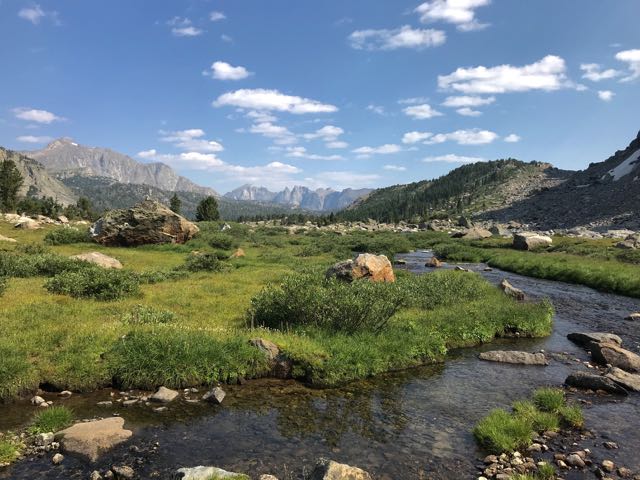
We took the 5AM hiker shuttle to the South Kaibab trailhead where we spoke with a guy who has been doing Rim to Rim to Rim runs every year for the past 22 years. He said that he has an 8PM dinner reservation at the Tovar. We hit the trail at 5:30 (well after sunrise in Arizona MST) and arrived at Phantom Ranch at about 9. We drank some lemonade and sat for a bit and then started the Clear Creek Trail at 10AM: just the time they recommend a break in hiking. It starts with a steep climb up 2000 or so to a ridge just short of the Tonto Plateau and then completes the climb gradually over several miles. There were only a few shady rest spots. When we stopped for a break at 12:00 I was shocked to see that it was only 72 degrees: it felt much hotter in the sun. I’ve never used an umbrella on a hike, and didn’t see anyone this trip doing it, but I think that it would have been well worth its weight for this particular trail. Still, the views were amazing and we had plenty of water so I’m glad that we didn’t wait it out and risk finishing the hike down the red scree into Clear Creek in the dark. We arrived at the first creek campsites at 2PM and after a nice foot soak in icy water all was right with the world. In contrast with the silence I’d experienced in my only other night below the rim (at Indian Gardens) the frogs were making quite a racket here. They sounded like chainsaws. There were also a few mice poking around but they gave up pretty quickly because all of our food was hung on a thin line strung between two trees.
In the morning we had a quick breakfast of coffee and oats and headed north up Clear Creek. My goal was to find the granary that’s supposed to be there a few miles up the creek. I had two sets of coordinates and had cached the area on Google Maps but both locations were duds and I never found any ruins. Free of our packs, we did quite a bit of pointless scrambling up scree piles just because it was fun and enjoyed seeing the little canyon from lots of different positions. I’ve never really done the base camp thing but I like it. We got back to the site in the afternoon and chilled until the sun got a little lower. Our original plan was to hike towards Sumner Wash that evening and stop at near sunset to get an early start on the Utah Flats the next morning. It was nearly a full moon and although I prefer a dark sky for the stars I thought that the moonlit canyon would be nice. We got a bit put off by the wind which we heard from our protected spot and decided to stay put.
We’d made friends with a party of four camped nearby who had been marveling at our tiny packs as they were lounging on chairs and cots. Later in the evening as I walked by their site to get water they produced a full-size glass bottle of Islay Scotch and a set of shot glasses. Not wanting to be rude, I sat with them for a while and enjoyed the fruits of their glass burden while watching the last of the highest peaks give up their direct illumination. In the morning we rolled out at about 6 and made it back to near the Phantom Overlook before 10. On the way we met a girl who was headed for a climb up Brahma Deva but didn’t see anyone else. I don’t really mind the crowds on the corridor trails but the relative solitude we’d enjoyed the past few days was nice.
This is where the trip got cut short. We had been radio silent for the last two days due to lack of cell coverage. As we approached civilization we got a text about a death in the family and realized that we had to get home. I tried to call family for details but could barely hold a connection for more than a few seconds at a time. We waited out the heat at Phantom Ranch drinking lemonade and writing a eulogy for my hero: the man who among other things introduced us to western camping in the Sandias 25 years ago. I tried to make a call from the payphone but don’t have a phone card and the ATT operator actually laughed when I asked if I could charge a call to my ATT home phone.
Before leaving the Bright Angel campground we ditched our packs for a minute and did the first bit of the scramble up towards Utah Flats. It was fun without packs and I think that the climb would have been fine even with them. We crossed the river at about 3:30PM and broke for dinner at Indian Gardens where I gave my permit to a grateful ranger (we never saw a ranger at or around the Bright Angel/Phantom Ranch ranger station) and emerged on the chilly south rim at about 8:30PM with no hotel or travel reservations. I first tried the rim tent campground but it was booked. I then got the last room available in all of Grand Canyon Village at Maswik Lodge and made travel plans to get home. We booked an afternoon flight out of Las Vegas, got some pizza, and crashed. In the morning I woke up early and went on a walk on the rim trail and scoped out the Clear Creek trail using my monocular. I’d looked for the trail from the rim before we left but couldn’t see it then. This time I found it and was able to follow our path pretty far east. One thing I love about the Grand Canyon is viewing features from multiple points. It’s like an interactive 3-D puzzle trying to build a model in my head and keep track of the major peaks.
On the drive back we stopped briefly at Hoover Dam and wished we’d allowed enough time to tour the inside. The last time I’d been there a few years ago the highway bridge that bypasses the dam had not yet been completed: at the time it consisted of two precarious-looking structures poking out from the rocks towards each other but still open in the middle. It was nice to see it completed. It’s a beautiful structure and I’m sure that the folks who have to use that road are glad that they don’t need to cross the top of the dam anymore.
I’ll be back in late June for 4-day trip with my sister and her son. This will involve solely corridor campsites (BI-CG-BI-IG) and two Phantom Ranch meals (one steak, one stew). I plan to ditch my pack for a few hours and take a peek at Piano Alley and maybe Phantom Canyon from the top. The Grand Canyon is a wonderful place and I doubt I’ll be tired of it even after this next trip.
My sister, her son, and I camped four nights below the rim on the main corridor campgrounds during the end of June and early July. It was hot but we embraced the brutality and enjoyed the trip. I put a few pictures on https://www.instagram.com/d41253/ but there are so many better ones out there I won't bother trying to figure out how to post any here.
We converged on Las Vegas from Florida and Texas and arrived at the South Rim late in the afternoon. We ate dinner at the Arizona room and settled in at our Mather Campground campsight. A little after sunrise we drove to the Visitor Center, as close as you can get in a rental car to the South Kaibab trail, and took the park bus one stop to the trailhead. I wish I'd thought of parking at the Visitor Center back in May when we were staying at the Bright Angel Lodge: The bus leaves more often from there and the ride is much shorter.
This was the third time I'd been down the South Kaibab trail and it was still breathtaking. It was even better seeing it through the eyes of Florida-dwelling canyon newbies. We didn't hurry or dawdle and arrived at the Bright Angel campground in about four hours. It was well before noon and already hot. I think that the high was about 108 that day and every day below the rim this trip. We spend most of the day soaking in the lovely Bright Angel Creek. It felt ice cold. My thermometer showed the water at 70 degrees. It wasn't too hard to get comfortable as long as we stayed in or near the water.
I wore a long-sleeve thin hoodie that I got from a race and put the hood up in the brightest part of the day. We were never far from water this trip so were able to keep parts of our clothing wet and also had wet bandanas against our skin pretty much the entire time. Most days by evening it got down to the mid-80s and wasn't too bad for sleeping in minimal clothing the help of wet bandanas. We all wore big old gooney hats that helped a lot with the sun. I kept sunscreen on the upper exposed parts and never got burned.
That first night we ate a steak dinner that my sister had generously reserved months in advance. We also had stew reserved for two nights later. It was nice not having to worry about packing so many meals or getting sick of dried food. The steak wasn't great: they were all cooked beyond well-done to a solid grey. I preferred the stew two nights later and the novelty of fresh salad was much more appreciated after several days deprived of fresh food. If doing it again I'd carry something nice down and cook it myself for the first night. A decent steak probably would have been medium rare without a fire by 6PM.
After dinner we watched an interesting program on the history and uncertain future of the trans-canyon water line. Someone asked why they don't pump water from the Colorado and Ranger Elisa said that it's because the park doesn't have water rights. I thought that it was funny that they could pump water from a creek a few minutes before it flowed into the river but couldn't instead remove that same amount of water from the river instead. They're forced by politics to build and maintain a cludgy pipeline down a crooked fault line and in the end the Colorado still has the exact same amount of water in it downstream of the Silver Bridge than it would if they'd pumped if directly from the river. The inertia of the water in the pipeline does reduce the pumping energy to the South Rim by a factor of two, but I wonder how that energy cost compares what it will take to re-build the pipeline as time goes on. It's already well past its design life.
Earlier in the day we'd chatted with a ranger about what to see on our way to Cottonwood the next day. He suggested that we head straight for Ribbon Falls as early as possible and stay there until at least 5PM. That was great advice. We enjoyed a slow hike through "The Box" and still got to the falls just as it was starting to get toasty in the sun on the trail. The bridge to the falls is marked as closed because the decking is about shot but it wasn't too scarey. The air was noticeably cooler near the water and the place was absolutely beautiful. We spent several hours a few hundred yards downstream of the falls lying and playing on rocks around a little pool of cool water. After a while I blew up my Neoair, cracked open a chilled Firestone Walker Leo v Ursus Fortum, and floated in the cool, shaded pool. That beer was worth every mile-ounce of portage. As the sun shifted we headed upstream and hung out on the upper ledge behind the falls. It was even cooler up there with the mist and perpetual shade. The view into the bright, hot desert canyon from our cool oasis was stunning and felt like cheating. Context is everything, but that has to be one of the most beautiful places I've ever seen. We spent hours there scanning around at various features with binoulars, wading, and dozing. I was amazed that we only saw two of three other groups there all day.
At 6:30, a little more than an hour before sunset, we headed for Cottonwood. That campground is not a place where I'd want to spend much time. Since we didn't have to worry about the sun we picked a treeless site and had great views of the stars after the moon set. We headed back to Bright Angel Campground the first thing in the morning, having spent less time there than we had at Ribbon Falls. Back at the campsite my companions were happy to settle in at the creek again but I wanted to get a taste of what I'd missed when last month's trip got cut short. My son and I had planned to hike up Utah flats and stay in upper Phantom Canyon.
At 10AM, exactly when sensible people are hunkering down, I told my companions that I'd be back within two hours, grabbed some water, soaked my clothes, and headed up the rocky path from the north end of the campground. I made it to near the top of the scarey part but not quite to Utah Flats proper. I finally turned around when the rocks I needed to grab were too hot to hold onto and I got a mittfull of cactus in my left palm. I headed back down, re-set the panic clock with my companions for three hours, and headed alone to Phantom Creek.
On the way I met a girl who was running back to camp with some empty bottles. She asked me if I had any extra water for her friends resting in one of the few shady spots a little ways up the trail. I had a full liter of tap water and my Sawyer Mini so when I saw her friends I gave them my tap water. The moral of that story is that it makes sense to either bring a little water filter or don't be afraid to take a chance on drinking Bright Angel Creek water in case you run out.
Phantom Creek was a much better plan in the middle of the day than Utah Flats! If fact, if the weather had been much cooler it wouldn't have been as much fun. The creek is noticeably less cold than Bright Angel Creek. This is a good thing because I spent most of my time in it. I spashed upstream for about 20 minutes and was blocked by a large waterfall with a rubble pile on the left side. I'd read about this and had no trouble carefully climing the rock pile to an amazing wonderland of sequential stone bathtub pools flowing into one another. At one point the only path upstream was through water above my head against a decent current and up a small waterfall. I did that and just rested there for a while. I wished I'd budgeted a little more time to explore farther upstream but it was nice just hanging there for a while. Again, I'm amazed that I didn't see a soul anywhere around after I turned off the main trail. The falls weren't as dramatic as Ribbon Falls but the canyon walls were beautiful, varied, and fascinating. This is definitely a part of the canyon I want to expore further the next time.
On the way back I ran into Masked Ranger Betsy (I hope I got her name right) who (along with Ranger Elisa) helped my son and me out when we'd overextended ourselves in the canyon a few years ago. I thanked her again and we chatted briefly before she continued her afternoon sweep up the North Kaibab. That night we enjoyed the stew dinner at the Phantom Ranch canteen. After sundown it was crazy-hot! The wind was blowing strong like a convection oven. Sand blasted into our eyes and hair. I put a rock on my Neoair to keep it from blowing away when I got up one time and it sprung a leak so I woke up on the hard ground.
We woke with the sunrise and headed up to Indian Gardens. The hike was gorgeous and we took our time to look around and explore side features like a little cave that looked like an aborted tunnel. When I found the intersection with Old Bright Angel Trail near the top of Devil's Corkscrew my companions wisely rejected my plan to take a shortcut and maybe see some Indian ruins. They're familiar with my shortcuts. We arrived at camp a little later and I grabbed an early lunch (rehydrated black bean burritos seasoned with Flaming Hot Limon Cheetos, again!), set the panic timer for three hours, and headed back to try to catch the Old Bright Angel Trail from the Tonto. I found it (using the phone line as a marker) and realized that doing that particular stretch of decommissioned trail with packs would have been a very bad idea. I searched around a bit and never found the ruins. I wish I'd looked at the Youtube videos ahead of time instead of after I got back home because I now know that I was very close. The trip was still worth it, though, because I got to see more canyon and trail features from more angles. I really enjoy the 3-D puzzle aspect of the canyon.
That night about an hour before sunset we all headed out to Plateau Point. The flat rock viewpoint at the end was a little scarey for us; we quickly retreated back to just before that point. From there you can see just about every trail we'd been on, including the top of the Devil's Corkscrew and the Old Bright Angel intersection. Again, it was fascinating to see the geographical feature that the old and new trails follow on either side. We enjoyed the sunset and headed back. I was awfully tempted to just lie there for a few hours until the moon set and maybe fall asleep for a while (napping isn't camping as long as all your stuff is at your permitted site, is it?). I probably would have done it if I'd been alone.
In the morning we did the last bit up the Bright Angel in about four hours and had a huge breakfast at the Bright Angel Lodge restaurant. We showered at Mather Campground (bring flip flops next time!) and headed back to Las Vegas with a quick stop at Hoover Dam.
Would I go back again in the peak of summer? Probably not, but I'm glad that I did it once. I will definitely be back to finally hike Utah Flats and explore the upper part of Phantom and Haunted Canyons. I'd also like to spend a little more time back Clear Creek. It really is a magical place. My sister and her son said that they were glad that the trip hadn't been any harder, but they were also glad that it hadn't been any easier. These will be some good memories.
I guess I'll break protocol here and actually thank you for your trip write ups. Hoping to do Clear Creek next April, and out via Horn. Same idea as your trip. BA and IG get a little crowded, though the first few times, I didn't really pay attention-too busy looking up . I suspect my wife and I are quite a bit older, the heat would be hard to deal with. As it is we've hit 90 on the Tonto mid-day in April and that was enough. Thanks again for all the detail. Informative and entertaining.
I read most of the trip reports here and a bunch of other places and don't comment on them unless I have a question. Maybe a "like" button would be an efficient way to give a nod but it's a slippery slope from that to scores and ratings and who needs that?. I post here mostly as a convenient way to pass this around to local friends and to document things I wish I'd known for future travellers.
After having done these two GC trips this year I would probably simplify the May itinerary and stick with either Clear Creek or Phantom Creek rather than planning to go from Clear to Phantom in one day. It's not that the mileage was too high: we ended up doing quite a few more miles than planned on our last day when we hiked out early and we were fine. The reason to simplify would be to get the chance to explore more of one area in solitude and to really take advantage of the freedom of open camping.
I think I'll plan my next trip, which will probably be a few years away, for several days in the Phantom zone continuing up to Haunted Canyon. I think that the perfect itinerary would be to spend a night at Bright Angel Campground so we could ditch our stuff there and spend an afternoon splashing up Phantom Creek as far as possible. Then early the next morning tackle the Utah Flats Route and over the next few days see if we could close the loop by going down Phantom Canyon from upstream and look down on the point where we'd stopped coming from downstream. Then we could explore or just chill around Overhang, Hippy Camp, or whatever seemed interesting for a few days.
Clear Creek is definitely worth several days. It would be fun to camp in a few non-standard spots way up that canyon and also to spend one day going down to the river and back.
There's a reason the crowded places are crowded so it doesn't bother me much to see like-minded folks around the main attractions. Ribbon Falls is amazing and as popular as it is we had it mostly to ourselves for several of the hours that we were there. Plateau Point is also incredible, as much for the views of every one of the trails we'd been on as for the sunset.
There's so much to see there. BTW I'm in my late 50s so am not speedy but am also not in a hurry.
Our long-time Sponsor, BackcountryGear.com - The leading source for ultralite/lightweight outdoor gear:
Affiliate Disclaimer: This forum is an affiliate of BackcountryGear.com, Amazon.com, R.E.I. and others. The product links herein are linked to their sites. If you follow these links to make a purchase, we may get a small commission. This is our only source of support for these forums. Thanks.!


 Previous Topic
 Index
Index


